The Latest IN Technology Delivered Worldwide
Customer Service 020 30 111 888


Part Number 010-N0868-01
Garmin GPSMAP 62S Handheld GPS Worldwide Basemap Compass Altimeter Barometer
Newly Overhauled by Garmin and Guaranteed as New Condition
Dedicated customer support line
ITEM DISPATCHED FROM OUR UK WAREHOUSE
- RRP £179.99
- Only £147.95Save 18%
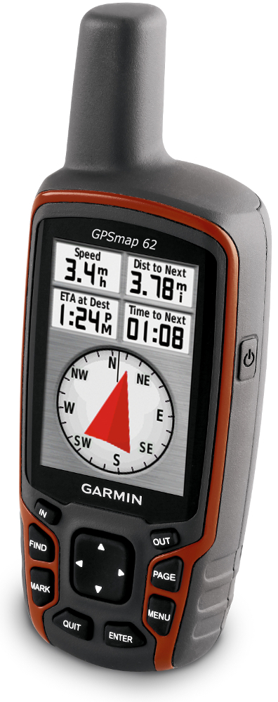
Rugged, Full-featured Handheld GPS with Wireless Connectivity
- 2.6" sunlight-readable color screen
- Built-in worldwide basemap with shaded relief
- High sensitivity quad helix GPS antenna for unparalleled reception
- 1.7 GB of internal memory
- 3-axis compass with barometric altimeter
- Supports BirdsEye satellite imagery, Garmin Custom Maps and photo navigation
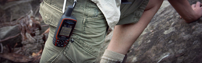
When the terrain gets tough, you can depend on the GPSMAP 62s handheld navigator to guide you through, with 3-axis tilt-compensated compass and barometric altimeter. Inspired by the powerful GPSMAP 60 series, this rugged and waterproof GPS combines high-precision accuracy with high functionality to brave the demands of any terrain you dare to tackle – wherever the adventure, whatever the activity.
Explore The Terrain
GPSMAP 62s features a 2.6-inch sunlight-readable colour screen with built-in worldwide basemap with shaded relief, so you can navigate anywhere with ease. With photo navigation, you can download geotagged pictures from the Internet and navigate to them.
Get Your Bearings
GPSMAP 62s has a built-in 3-axis tilt-compensated electronic compass, which helps you get your orientation and points you towards your destination even when you’re standing still, without holding it level. Its barometric altimeter tracks changes in pressure to pinpoint your precise altitude. View elevation and profile on the altimeter screen and you can even plot barometric pressure over time to keep an eye on changing weather conditions.
Share Wirelessly
With GPSMAP 62s you can share your waypoints, tracks, routes and geocaches wirelessly with other compatible Garmin GPS handhelds. So now your friends can also enjoy your favourite hike or cache — simply press “send” to transfer your information to similar units, and let the games begin.
Keep Your Fix
With a quad helix antenna and high-sensitivity, WAAS/EGNOS-enabled GPS receiver with HotFix® satellite prediction, GPSMAP 62s has unparalleled reception to locate your position quickly and precisely and maintains its GPS location even in heavy cover and deep valleys. The advantage is clear — whether you’re in deep woods or just near tall buildings and trees, you can count on GPSMAP 62s to help you find your way when you need it the most.
Enhance Your Navigation
With space to store up to 2000 waypoints and 200 routes, GPSMAP 62s’s detailed route planning and tracking helps you navigate from point-to-point and keep track of your journey as you go. As you navigate to a destination on an active track, you can view upcoming elevation changes together with waypoints and key stages along the route for a clear picture of the journey ahead. And with customisable display, you can tailor GPSMAP 62s’s dashboard to show you the details you need on your adventure.
Explore, Record, Create and Share your Adventures
You can make an adventure out of almost anything, whether you’re climbing a mountain, taking a road-trip, cycling or going out on a boat. Now you can share your activities with friends, family and fellow explorers viaGarmin Adventures. It’s a great way to show people where you’ve been and highlight your favourite places. You can add geotagged photos, YouTube videos, geocaches and notes, then share your adventure via email and social media. Simply upload your activity via our free BaseCamp programme to get started.
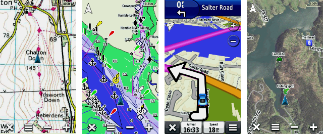
Add Maps
Adding more maps is easy with Garmin's wide array of detailed topographic, marine and road maps. You can download regions of our Garmin GB Discoverer mapping for OS Explorer (1:25k) and OS Landranger (1:50k) detail and hit the trail. The traditional look and feel of the Ordnance Survey map detail complements Garmin’s dynamic search capabilities. Use GPSMAP 62s to search, select and navigate to points of interest and street addresses and follow the route on foot, in the car or by bike with an Ordnance Survey backdrop. Add BlueChart g2 downloads for a great day on the water or City Navigator NT map data for turn-by-turn routing on roads (see maps tab for compatible maps). GPSMAP 62s also supports BirdsEye Satellite Imagery (subscription required), which lets you download satellite images to your device and integrate them with your maps. See the terrain in terrific clarity and high-resolution detail with satellite and aerial imagery on your GPSMAP 62s. BirdsEye works with your BaseCamp planning software, onboard maps and points of interest to add real-world images of buildings, roads, trails, mountains and other land features. In addition, the 62s is compatible with Custom Maps, free software that transforms paper and electronic maps into downloadable maps for your device. Put your favourite paper or digital maps on GPSMAP 62s by converting details, labels and landmarks from other maps and informal plans like ski piste routes, mountain bike trails or charity treks into tailored content that’s ready to navigate.
Get Connected
You've been busy exploring and now you want to store, save and share your routes, tracks and waypoints. With a simple connection to your computer and to the Internet, you can get a detailed analysis of your activities and send tracks to your outdoor device using Garmin Connect. Simply upload activities saved on GPSMAP 62 from your hiking, camping or geocaching adventure to keep a record on the web or swap ideas and expeditions with others. This one-stop site offers an activity table and allows you to view your activities on a map using Google Earth. Explore other routes uploaded by millions of Garmin Connect users and share your experiences on Twitter and Facebook. Getting started is easy, so get out there, explore, share and take your adventures further.
Find Fun
GPSMAP 62s supports geocaching GPX files for downloading geocaches and details straight to your unit. By going paperless, you're not only helping the environment but saving time you would otherwise waste manually entering cache details before you set off. GPSMAP 62s stores and displays key information, including location, terrain, difficulty, hints and descriptions, which means no more manually entering coordinates or paper print outs! Simply upload the GPX file to your unit and start hunting for caches. Slim and lightweight, 62s is the perfect companion for all your outdoor pursuits.
GPSMAP 62s: Take it to the extreme
Specifications
Physical& Performance | |
| Physicaldimensions | 2.4"x 6.3" x 1.4" (6.1 x 16.0 x 3.6 cm) |
| Displaysize, WxH | 1.43"x 2.15" (3.6 x 5.5 cm); 2.6" diag (6.6 cm) |
| Displayresolution, WxH | 160x 240 pixels |
| Displaytype | transflective,65-K colour TFT |
| Weight | 7.9oz (223 g) with batteries |
| Battery | 2AA batteries (not included); NiMH or Lithium recommended |
| Batterylife | 20hours |
| Waterrating | IPX7 |
| High-sensitivityreceiver | |
| Interface | high-speedUSB and NMEA 0183 compatible |
| Barometricaltimeter | |
| Electroniccompass | Yes(tilt-compensated 3-axis) |
| Unit-to-unittransfer (shares data wirelessly with similar units) | |
Maps& Memory | |
| Basemap | |
| Abilityto add maps | |
| Built-inmemory | 1.7GB |
| Acceptsdata cards | microSD™card (not included) |
| CustomPOIs (ability to add additional points of interest) | |
| Waypoints/favorites/locations | 2000 |
| Routes | 200 |
| Tracklog | 10,000points, 200 saved tracks |
OutdoorFeatures | |
| Automaticrouting (turn by turn routing on roads) | Yes(with optional mapping for detailed roads) |
| Geocaching-friendly | Yes(Paperless) |
| Custommaps compatible | |
| Hunt/fishcalendar | |
| Sunand moon information | |
| Tidetables | Yes(with optional Bluechart) |
| Areacalculation | |
| Pictureviewer | |
GarminConnect™ | |
| GarminConnect™ compatible (online community where you analyze,categorize and share data) | |
Additional | |
| Additional | ThisUSB mass storage device is compatible with Windows® XP or newerand Mac® OS X 10.4 or later. |
Whats in the Package?
- Garmin GPSMAP 62S Handheld GPS Worldwide Basemap Compass Altimeter Barometer
- Carabiner CLip
- USB cable
- Quickstart Guide
- Comes in plain white Retail Packaging.
- Buy with Confidence from a Garmin Authorised Dealer and All Purchases come with a VAT Receipt.

We want you to be ecstatic with your Purchase ! Please buy with total confidence.
If for any reason you are not happy with your purchase, simply contact us through eBay messages and we will issue you with a Returns number. You can then return the item in saleable condition for a Full refund (excluding postal costs), all that we ask is that the item is not used and all packaging is kept in its Pristine condition.
Please Note that this excludes software, mapping and Hygiene products as these can only be exchanged if faulty.
The Sustuu Store is a consumer electronics retail website dedicated to top brand-name manufacturers and specializes in the categories of GPS, home/office phones, personal care, pet products, and much more.
Interested in becoming a vendor?
We at Sustuu are always looking to expand our product line and build strong relationships with manufacturers and distribution partners.
For all inquiries, please feel free to email us at support@sustuu.com
Or give us a ring anytime from 09:00 to 17:30 GMT, Monday - Friday, on 0203 0111 888