|
"OVERLOOK" 20.66 Acre Lode Mining Claim in the Rhyolite, NV Mining District
No Reserve Auction
$1.00 Starting Bid
(And our guarantee that we will not cancel this auction early for a cash offer outside of eBay, as this Mining Claim is not listed for sale anywhere else) | |
|
|
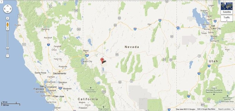
20.66 Acre Unpatented Lode Mining Claim on Federal Land in the Historic Rhyolite Nevada Mining District / Nye County Nevada
Welcome to the "OVERLOOK" Mining Claim!
SERIAL NUMBER NMC1087611
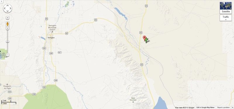
This claim is a real interesting one – literally right next to the famous producer, the Vanderbilt Mine – which is still in operation today. This at one time must have been where they processed ore – very close to the Rote 95 (150 yards), so no long dirt road to get to it, and a nearby year-round water source (not part of the claim, but public and only 200 feet from the property).
The mine on this claim looks to me like they never finished working it – as they probably got in deep on the Vanderbilt mine and poured all of their resources into it, but the amount of good tailings on the old mill site means that you would have plenty of materials to run without digging any deeper. I saw some great colors and excellet mid-grade ore just piled up and waiting for future recovery, so you could go to work on this one right away.
The town of Beatty Nevada is literally 2 miles up the road, so access to fast food, diners, motels, good restaurants/bars and even 2 casino’s is quick and easy.
Rhyolite is a ghost town in Nye County, in the U.S. state of Nevada. It is in the Bullfrog Hills, about 120 miles (190 km) northwest of Las Vegas, near the eastern edge of Death Valley. The town began in early 1905 as one of several mining camps that sprang up after a prospecting discovery in the surrounding hills. During an ensuing gold rush, thousands of gold-seekers, developers, miners and service providers flocked to the Bullfrog Mining District. Many settled in Rhyolite, which lay in a sheltered desert basin near the region's biggest producer, the Montgomery Shoshone Mine.
Industrialist Charles M. Schwab bought the Montgomery Shoshone Mine in 1906 and invested heavily in infrastructure, including piped water, electric lines and railroad transportation, that served the town as well as the mine. By 1907, Rhyolite had electric lights, water mains, telephones, newspapers, a hospital, a school, an opera house, and a stock exchange. Published estimates of the town's peak population vary widely, but scholarly sources generally place it in a range between 3,500 and 5,000 in 1907–08.
Rhyolite declined almost as rapidly as it rose. After the richest ore was exhausted, production fell. The 1906 San Francisco earthquake and the financial panic of 1907 made it more difficult to raise development capital. In 1908, investors in the Montgomery Shoshone Mine, concerned that it was overvalued, ordered an independent study. When the study's findings proved unfavorable, the company's stock value crashed, further restricting funding. By the end of 1910, the mine was operating at a loss, and it closed in 1911. By this time, many out-of-work miners had moved elsewhere, and Rhyolite's population dropped well below 1,000. By 1920, it was close to zero.
After 1920, Rhyolite and its ruins became a tourist attraction and a setting for motion pictures. Most of its buildings crumbled, were salvaged for building materials, or were moved to nearby Beatty or other towns, although the railway depot and a house made chiefly of empty bottles were repaired and preserved. From 1988 to 1998, three companies operated a profitable open-pit mine at the base of Ladd Mountain, about 1 mile (1.6 km) south of Rhyolite. The Goldwell Open Air Museum lies on private property just south of the ghost town, which is on property overseen by the Bureau of Land Management.


Come to Hike, Camp, Ride and Shoot - or come to pull some shiny rock$ out of the ground;-)
Note that all of the below pictures of this claim were taken by my team and/or myself on a recent visit to this property.
All Pictures are of the actual property – no stock photographs were used


OVER 150 High Resolution Photos below...
Depending on your internet connection, it could take a couple of minutes for all of the pictures to load.
Legal Description of This Claim;
The general course of this claim is East and West and it is situated in the Mount Diablo Meridian, Nye County, Nevada.
This claim is 1,500 feet in length and 600 feet in width. This claim runs from the location monument on which this location notice is posted approximately 1,200 feet in a Easterly direction to the East end line and approximately 300 feet in a Southerly direction to the South end line.
This claim is marked by four (4) monuments, one at each corner of the claim. Additionally, there are two (2) end-line markers on each side of the center of the claim. All markers are 4” x 4” wooden posts that are buried 1.5’ in the ground and protrude 4.5’ above the ground embossed with the name of the claim and its location in relation to the claim.
The location monument on which this notice is posted is situated within Section 18, Township 12S, Range 47E, Mount Diablo Meridian, Nye County, Nevada and this claim encompasses portions of the following quarter section (s), Township (s) and Range (s); SE 1/4 of SE 1/4 and SW 1/4 of SE 1/4 of Section 18, T12S, R47E, Mount Diablo Meridian, Nye County Nevada.
The locality of this claim with reference to some natural object or permanent monument and additional information (if any) concerning its locality are as follows: SW corner of this claim is the SW corner of Section 18, T12S, R47E.


RHYOLITE, NV
The town is named for rhyolite, an igneous rock composed of light-colored silicates, usually buff to pink and occasionally light gray. It belongs to the same rock class, felsic, as granite but is much less common. The Amargosa River, which flows through nearby Beatty, gets its name from the Spanish word for "bitter", amargo. In its course, the river takes up large amounts of salts, which give it a bitter taste.
"Bullfrog" was the name Frank "Shorty" Harris and Ernest "Ed" Cross, the prospectors who started the Bullfrog gold rush, gave to their mine. As quoted by Robert D. McCracken in A History of Beatty, Nevada, Harris said during a 1930 interview for Westways magazine, "The rock was green, almost like turquoise, spotted with big chunks of yellow metal, and looked a lot like the back of a frog." The Bullfrog Mining District, the Bullfrog Hills, the town of Bullfrog, and other geographical entities in the region took their name from the Bullfrog Mine.
Geography
The Bullfrog Hills are at the western edge of the southwestern Nevada volcanic field. Extensionally faulted volcanic rocks, ranging in age from about 13.3 million years to about 7.6 million years, overlie the region's Paleozoic sedimentary rocks. The prevailing rocks, which contain the ore deposits, are a series of rhyolitic lava flows that built to a combined thickness of about 8,000 feet (2,400 m) above the more ancient rock.
After the flows ceased, tectonic stresses fractured the area into many separate fault blocks. Most of these blocks tilt to the east, and the horizontal banding of individual flows shows clearly on their western scarps. Within the blocks, the ore deposits tend to occur in nearly vertical mineralized faults or fault zones in the rhyolite. Most of the lodes in the Bullfrog Hills are not simple veins but rather fissure zones with many stringers of vein material.
Climate
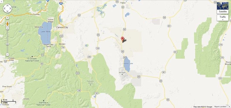
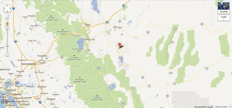
Rhyolite is at the northern end of the Amargosa Desert in Nye County in the U.S. state of Nevada. Nestled in the Bullfrog Hills, about 120 miles (190 km) northwest of Las Vegas, it is about 60 miles (97 km) south of Goldfield, and 90 miles (140 km) south of Tonopah. Roughly 4 miles (6.4 km) to the east lie Beatty and the Amargosa River. To the west, roughly 5 miles (8.0 km) from Rhyolite, the Funeral and Grapevine Mountains of the Amargosa Range rise between the Amargosa Desert in Nevada and Death Valley in California. State Route 374, passing about 0.75 miles (1.21 km) south of Rhyolite, links Beatty to Death Valley via Daylight Pass. Rhyolite is about 25 miles (40 km) west of Yucca Mountain and the proposed Yucca Mountain nuclear waste repository, which is adjacent to the Nevada Test Site.
Bordered on three sides by ridges but open to the south, the ghost town is at 3,800 feet (1,200 m) above sea level. The high points of the ridges are Ladd Mountain to the east, Sutherland Mountain to the west, and Busch Peak to the north. Sawtooth Mountain, the highest point in the Bullfrog Hills, rises to 6,002 feet (1,829 m) above sea level about 3 miles (4.8 km) northwest of Rhyolite. The hills form a barrier between the Amargosa Desert and Sarcobatus Flat to the north. Most of the primary mining communities in the Beatty–Rhyolite area during the gold-rush boom of 1904–08 were either in or on the edge of the Bullfrog Hills. Of these and many smaller towns and camps in the Bullfrog district, only Beatty survived as a populated place. Prior to its demise, the rival town of Bullfrog lay about 0.75 miles (1.21 km) southwest of Rhyolite, and the Montgomery Shoshone Mine was on the north side of Montgomery Mountain, about 1.5 miles (2.4 km) northeast of Rhyolite.
Nevada's main climatic features are bright sunshine, low annual precipitation, heavy snowfall in the higher mountains, clean, dry air, and large daily temperature ranges. Strong surface heating occurs by day and rapid cooling by night, and usually even the hottest days have cool nights. The average percentage of possible sunshine in southern Nevada is more than 80 percent. Sunshine and low humidity in this region account for an average evaporation, as measured in evaporation pans, of more than 100 inches (2,500 mm) of water a year.
Beatty, about 500 feet (150 m) lower in elevation than Rhyolite, receives only about 6 inches (152 mm) of precipitation a year. July is the hottest month in Beatty, when the average high temperature is 97 °F (36 °C) and the average low is 61 °F (16 °C). December and January are the coolest months with an average high of 54 °F (12 °C) and an average low of 27 °F (−3 °C) in December and 28 °F (−2 °C) in January. Rhyolite is high enough in the hills to have relatively cool summers, and it has relatively mild winters. However, it is far from sources of water.


What Do I get if I Win This Auction with the Highest Bid?
100% ownership of this entire mining claim and the rights to any surface or subsurface minerals found on the property.
There are no additional costs or fees – your winning bid is 100% of the purchase price. Within 2 business days of payment in full, we will overnight you maps, information on mining claims from the BLM, GPS Coordinates, a Quit Claim Deed and a Bill of Sale for this claim so you can visit the claim immediately upon full payment.
The Quit Claim Deed can take up to 60 days to be recorded with the Mohave County Recorder’s Office, but is often completed in 30 days or less, and you will received a copy of the recorded deed in the mail as soon as it is returned by the Recorder’s Office.
Just to repeat this so there is no confusion - if you win this auction when it closes by having the highest bid, no matter how low the final bid is since there is no reserve on this auction, you will own this entire claim. This is NOT an auction for the down payment, this is NOT a partnership arrangement where someone else will own part of the claim with you, and there are NO fees or costs for the transfer of this claim into your name.
Your payment of the auction price gives you 100% ownership of this entire claim, all fees and other costs for the transfer of ownership included.


ACCESS
This entire area is relatively easily accessible by dirt roads which are well marked and well maintained. A 2-wheel drive car can get to this claim off of route Route 95, but I would recommend a good 4-wheel drive or even quads to be able to access the entire claim that is not on the road.
The area is full of dirt roads, so a good map and a good GPS unit is a must, but we'll show you exactly where it is on the map as well as provide you with the precise latitude and longitude of each corner marker, so finding it will not be a problem for you.
I advise caution whenever driving or hiking on this claim – the entire valley is dotted with abandoned mines – some of them are easy to see from a distance, and some of them are impossible to see until you are right on top of them. I would estimate that only 20% of them are roped or fenced off – the rest are wide open and you should be extremely careful if entering them.
A couple of spare tires or an air compressor and patch kit or at least a couple of cans of tire sealant is strongly recommended for obvious reasons! Also, be sure to bring in whatever water you may need, as there are almost no water sources in the area 10 months out of the year.


Information on Mining Claims in General;
A mining claim gives the holder the right to mine on mineral-rich land that belongs to the federal government.
Mining claims are a tangible asset and show proof of all interests in minerals in the area. They can be bought, sold or used as collateral, just like real estate. A mining claim can be sold, traded, leased, gifted, willed or transferred in part or in its entirety just like any other real property using a quitclaim deed which is a recordable conveyance.
What are you purchasing with this auction?
This auction is for full/all interest in this 20.66 acre lode mining claim. This claim covers the entire site, 1,500 ft. by 600 ft., and includes full rights to all minerals, gems and just about whatever else you may find on the property. The winner of this auction will receive a quit claim deed to the full claim and all associated documentation showing full ownership of the claim.
Maintenance on all BLM mining claims is $140.00, per 20 acre parcel, annually. This must be paid on or before September 1st, every year unless you do more than $100 per year in improvements to the property, in which case you can file for and receive a waiver of the maintenance fee.
The fees for the 2013 mining year have already been paid on this property, so you will not have to worry about paying anything else until September one of 2013 for the 2014 mining year. And then your fees will be only $140 per year.
NOTE: If you own fewer than 10 claims nationwide, we can assist you in filing the paperwork to waive the maintenance fee every year. That means you can only plan on paying $10 per year for your maintenance fee instead of $140.
And let me just re-state once more the answer to the one question that I get asked the most often; you are bidding for full claim ownership, not just a down payment or a part of this 20.66 acre claim. Auction end price is the final price for the entire site – there are no phony transfer fees or handling costs of any kind!


OTHER FREQUENTLY ASKED QUESTIONS
Transfers of Ownership in Mining Claims;
Interest in a properly recorded mining claim or site may be transferred in part or its entirety. A quitclaim deed or recordable conveyance document is needed. Transfer documents should be filed within 60 days after the transfer. There is a charge of $10 per claim, per transfer document. We pay this fee on your behalf for this transfer - not charge you for it. And should you desire to transfer your claim into a different name, it will only cost you $10.
Can you camp on your mining claim?
Yes, as owner of an unpatented mining claim you are allowed to camp on your claim pursuant to the rules of the surface management agency.
In a nutshell, the rules are pretty simple on this; if you are not doing any mining, you are permitted to camp on your claim 14 days every month maximum. However, if you are mining (even by the standards they designate as "recreational" mining - which can mean a day or two a week you get your shovel out and move some dirt), you can camp indefinitely on your property.
You can store whatever equipment you need to support your mining efforts, and you can make infrastructure improvements to your property to help your operation.
Can you build on your claim?
You are allowed to build on a claim with restrictions if the structures are in direct support of mining activities. Contact the surface management agency for details.
Again, this covers everything from building storage shed to shelter your equipment and tools to building a gate at a mine entrance for security. As long as you are at least doing some recreational mining, you can build on this property if you submit a plan and get a permit.


LEGAL NOTES
We do not make any claims with regard to quantities of any minerals on this site, concentrations of any minerals on this site or how much profit can be made mining for minerals. There are too many outrageous or inflated claims out there – mining is hard work and can be dangerous. Please do your research prior to doing any mining so you educate yourself on how to minimize risk.
Don't let anyone tell you that you can make thousands of dollars a week without first doing your own analysis of the area and its potential.
Although past success/history should not be confused with a guarantee of future success, it can at least show that an area is still economically viable as a mining area, so again - feel free to do your own research and even an onsite survey/assay if you would like. We'll give you our permission in writing and we'll give you exact coordinates to the location if you e-mail us, as there is no reason to hide the location or scare anyone into thinking that by others having the location they can clean out every last rock on the property in less than a week. The reality is, all claims are on public lands, so access is never denied, even by the Government!
We cannot provide legal advice; however feel free to ask any and all questions, as we can point you in the right direction for quick answers if we can't answer them for you ourselves.
This auction is not for any natural cave formations of any sort or ownership of a cave or any sort of cave related items. This auction is for a mining claim which provides for the control of any locatable minerals on the mining claim described above.
This Auction does not constitute any sale of stocks or other security interests that represent a current investment ownership interest in an entity or entities.


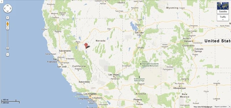
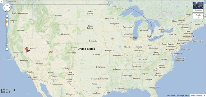
MAPS


| |
| NEWS FOR 2012 |
|
DLTI and BLM Partner on AML
Los Angeles, CA
May 09, 2012
The Department of Land Transfer Information (DLTI) has now partnered with the Bureau of Land Management (BLM), Abandoned Mine Land (AML) program. Approximately 18,000 abandoned mine sites on public lands in California alone. |
|
|
Goals of AML Program Revised
Sacramento, CA
July 19, 2012
BLM’s AML program goals are to improve safety for the public when visiting public lands and improve damages to the environment, prioritizing on populated places and high use recreational areas. The California BLM-AML program goals tiers off the National Strategic Plan for the Abandoned Mine Lands. |
|
|
New Program Accomplishment Numbers Released
Sacramento, CA
September 18, 2012
Between 2006 and 2011 the BLM and its partners re-mediated hundreds of AML physical hazard sites and major water quality sites.
Over 2,000 features were inventoried, and sites characterization was completed on 1,800 sites.
California AML Program Results
- 3,400 AML’s have been evaluated or characterized since 2005; 1080 characterized in 2011.
- 750 physical safety hazards secured since 2005; 293 remediated in 2011.
- 26 AML’s remediated for water quality since 2005; 14 remediated / evaluated in 2011 |
|
Frequently Asked Questions
What hazards are associated with AML sites?
- Environmental hazards: Contaminated mine tailings that contain mercury, arsenic and/or acid mine drainage threaten water supplies, communities and habitat.
-Current Project – The Deer Creek AML cleanup project located in the Nevada City area is currently undergoing a study to investigate the impacts of historic mining and associated contamination of mercury on BLM lands. The Sierra Fund is a partner on this project.
- Physical hazards: Unsecured AML sites pose a risk of death or serious injury resulting
from falls down open mine shafts.
-Current Project – Physical safety hazard remediation work performed by the California Department of Conservation as part of an Assistance Agreement with BLM during the first half of FY11 included closing approximately 110 AML features in the Johannesburg/Randsburg area of the California Desert.
BLM
How are sites selected as priorities?
BLM’s highest priorities are for areas with AML sites located in close proximity to populated places (e.g. schools, subdivisions, recreational areas, communities) and high use areas such as roads and trails. The strategy for the CA AML program is to remediate all physical safety hazard features within one-quarter mile of a populated place. This work is approximately 30% complete.
Partnerships
Our partners are integral to the success of the AML program. We work with over 20 federal, state, and local partners as well as private organizations to help us achieve our goals. The Department of Conservation - Office of Mine Reclamation assists the program in our inventory efforts as well as providing expertise in securing physical safety hazards. Other partners include the U.S. Geological Survey, U.S. Army Corp of Engineers, National Park Service, and the U.S. Forest Service, State regional water boards, and mining companies.
Budget and Funding Needs
Over the past ten years the California AML program has received more than $30 million dollars. In fiscal year 2010 the AML program received over $12 million dollars. The combined cost to address the large environmental AML sites such as the Rand Historic Mining District will require over $100 million dollars. In addition, the inventory and physical safety hazard securitization will require over $30 million dollars in funding. | |
|
|
Bid with CONFIDENCE - we are a very reputable eBay seller, with a 99.8% POSITIVE feedback rating, eBay I.D. Verified AND PayPal Verified with over 18,000 payments received, and not a single PayPal complaint or dispute
-PLUS-
We'll take care of all of the paperwork and arrangements so you can enjoy your claim immediately after payment AND we keep you informed through the entire process with confirmations when payment is received, when your paperwork has been overnighted to you with UPS and we'll make sure you have the tracking number the day it ships!
See our eBay Store,  MREdepot, for dozens of other mining claims, military trucks and disaster & emergency preparedness items like shelf stable foods. MREdepot, for dozens of other mining claims, military trucks and disaster & emergency preparedness items like shelf stable foods.
PAYMENT: Payment by PayPal (preferred and PayPal eChecks just as welcome!), Money Order, Cashier's Check, Personal Check (allow 5 to 7+ business days to clear), American Express, Visa, Master Card & Discover Card (credit cards through PayPal even if you don't have an account with them - it is quick, easy and safe). | |

Powered by eBay Turbo Lister
The free listing tool. List your items fast and easy and manage your active items.
|