


 Additional Information


To contact our Customer Service Team, simply click the button here and our Customer Service team will be happy to assist.
© Johnny Appleseed GPS
The Rino 750 handheld combines map-guided trail navigation with 2-way radio navigation, featuring a powerful 5 Watts 80 Channel UHF Radio, dual GPS and GLONASS satellite reception, Active Weather updates, emergency alerts with Position Reporting, Bluetooth® headset audio, 3-axis compass, barometric altimeter and more. The Rino 750 also supports advanced mapping capabilities such as BirdsEye Satellite Imagery (additional subscription required).
The Rino 750 is more powerful than the 700 on a feature-to-feature basis. The Rino 700 is a niche product designed to maintain the core features of the Rino series while offering a more affordable entry point for some consumers.
Find out what’s changed between the Rino 700 vs the Rino 750.

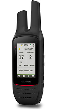
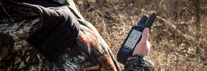
Featuring an easy-to-read, dual-orientation, 3-inch color touchscreen, the Rino can be uséd in bright sunlight and is also glove friendly. Stay in touch with your fellow hunters, hikers, explorers in the field with its powerful 2-way radio transceiver which also has the capability to send unit-to-unit text messages to Rino users in your area – ideal for loud of windy conditions or when you don’t want to disturb the wildlife. Wirelessly share your waypoints, tracks, routes and geocaches with other compatible Garmin handheld devices.
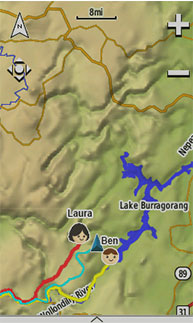
Rino series handhelds feature a unique Position Reporting capability that lets you send your exact location to other Rino users, letting them see where you are on their map page. The 750’s improved audio performance makes it easier to communicate with any other conventional UHF radios in the area.
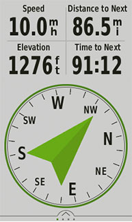
Whether you’re in heavy cover or remote, off-the-grid locations – the Rino 750 quickly finds your position and maintains it thanks to its high-sensitivity GPS and GLONASS receiver and quad helix antenna. Plus, a built-in barometric altimeter and 3-axis compass make it easy to get your bearings without having to hold the unit level.
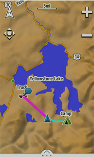
The Rino 750 comes with a worldwide, shaded-relief basemap. With the wide array of detailed Garmin marine and road maps available, it’s easy to install additional mapping products by using the unit’s microSD™ card slot to load any compatible mapping options that you want. Or you can use Garmin’s free Custom Maps software to transform paper and electronic maps into downloadable maps for your device.
Enhance your radio communications by syncing a compatible Bluetooth-enabled headset to your Rino 750, even under adverse weather or wind conditions. Stay focuséd on the trail ahead with smart notifications (calls, text, emails and more) right on your display by syncing your Rino with a compatible smartphone – keeping you connected with friends and family back home.
The Rino 650 is durable and water-rated to IPX7, built to keep delivery vital mapping and data tracking data, no matter what the elements throw at you. The included rechargeable lithium-ion power back can provide you with 14 hours or more in the field and the dual-battery system gives you the choice of using the power pack or a AA battery pack (sold separately).
BaseCamp™ software by Garmin lets you take charge of your next adventure by letting you view and organize maps, waypoints, routes and tracks. This free trip-planning software allows you to create Garmin Adventures that you can share with friends, family or fellow explorers. You can view topographic map data on your computer screen, including contour lines and elevation profiles. Paired with a BirdsEye Satellite Imagery subscription, you can transfer an unlimited amount of satellite images to your device.
Track multiple Rino units by turning your laptop into a field command centre with Garmin BaseStation. You can view real-time GPS information on your computer’s display while your Rino 750 serves as a router/antenna. And because it’s Garmin GPS-based, you are in control of more effective search and rescue operations, even when internet or cell phone service isn’t available.

Click the Postage tab above the listing description for more info
Click the Postage tab above the listing description for more info!
 Additional delivery notes
PICK UP OPTION
Sorry, our items are NOT available for pick-up.

|
PAYING VIA PAYPAL |
We accept PayPal on our all our items so you can shop with confidence.
Simple choose the PayPal option when proceeding through the checkout.
To contact our Customer Service Team, simply click the button here and our Customer Service team will be happy to assist.
© Johnny Appleseed GPS
Click the Postage tab above the listing description for more info
Accepted Payment Methods
Returns are accepted
Items must be returned within 30 days of the auction ending
Buyer will pay for return shipping.
