Department of
Land Transfer Info
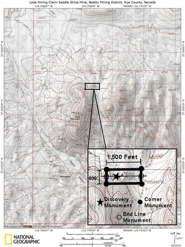
SADDLE SHINE MINE
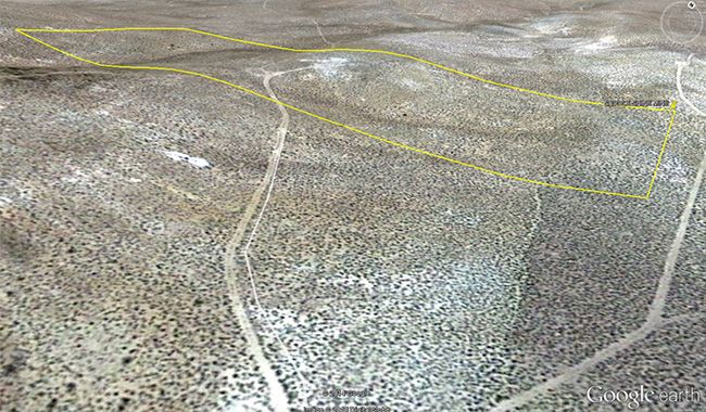
20.66 Acre Unpatented Lode Mining Claim on Federal Land in the Historic Beatty Mountain Nevada Mining District / Nye County Nevada
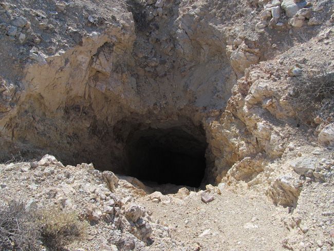
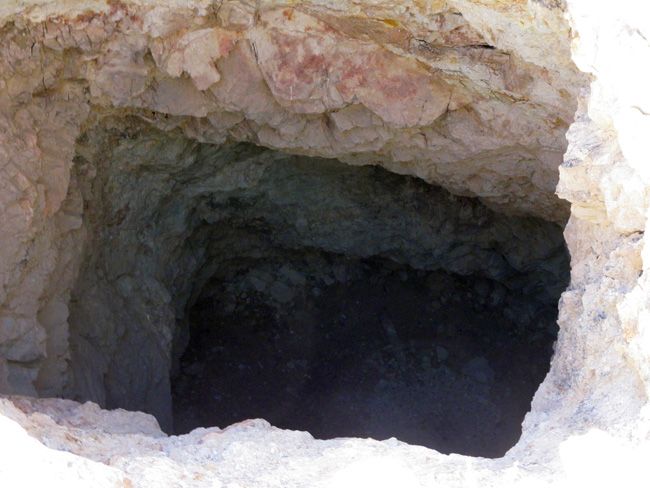
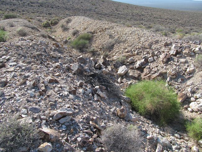
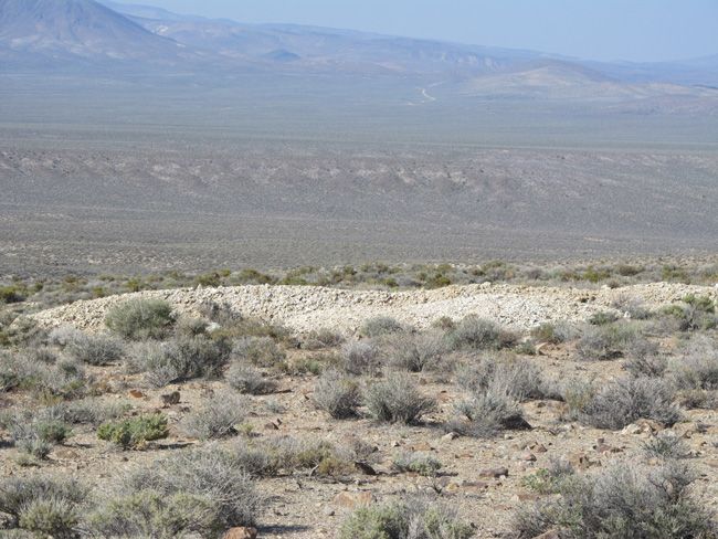
This mine in the Beatty Mountain Nevada Mining District is a massive shaft. The shaft declines at a 40 degree angle for 261 feet. The headframe is gone but the anchor points are still fairly solid, as is the mine. There is a large open cut in the vein. Our XRF gun picked up some very good gold AND silver values based on just surface measurements in a few areas – worth crushing up some rock and panning the gold to find even more most likely. Scroll down to see XRF readings. The vast majority of the tailings look to be worth reworking using today’s much more efficient processing methods.
(Scroll down to see all pictures)

Come to Hike, Camp, Ride and Shoot - or come to pull some shiny rock$ out of the ground;-)
ABOUT THE MINING DISTRICT
BEATTY MOUNTAIN MINING DISTRICT, NYE COUNTY, NV
ABSTRACT
The Bare Mountain (Fluorine) mining district, located on and around Bare Mountain, southern Nye County, Nevada, has produced gold, mercury, fluorite, clay, silica, and some marble beginning in about 1905. Gold and fluorite production from separate deposits continues from the district. Mineral deposits at Bare Mountain consist of gold-base metal-quartz vein deposits that are mainly confined to Precambrian and Cambrian host rocks and are located along the west slopes of the range. Gold-mercury-fluorite deposits in Precambrian-Cambrian sedimentary rocks and Tertiary volcanic rocks are located mainly along the north and east margins of the range. Copper, lead, zinc, cadmium, silver, and antimony are associated in the gold-base metal-quartz vein deposits and are interpreted to represent an early period of mineralization at Bare Mountain. Gold, molybdenum, arsenic, and mercury are associated with fluorite in breccias and breccia pipes along the north and east margins of the range and are interpreted to represent a separate, later period of mineralization, possibly related to outer ring fracture zones of the nearby Crater Flat or Timber Mountain-Oasis Valley caldera complexes.


Portable X-Ray Fluorescence field units (also known as XRF guns) are commonly used by large commercial mining operations, well-equipped/funded private prospectors and even the Environmental Protection Agency (EPA) as well as many other government agencies for the most accurate field sampling in the quickest amount of time. In no way do we advise that you base all of your commercial mining valuations on just one or two samples (regardless of how accurate the method that you use to sample is), but this extremely precise and versatile $40,000 device is equipped with powerful X-ray tubes, specialized filters, highly advanced detectors, and multi-beam optimization that efficiently analyzes the chemistry of the rock, soil, and sediment that hosts metals, for a quick and extremely accurate analysis of even trace levels of metals like silver, lead, gold, platinum, copper and many other elements.
Today’s highly sensitive XRF Handhelds (we use the best unit available on the market – an Olympus Delta Premium with a full mining package) work by emitting an x-ray beam with enough energy to displace the electrons in the inner shells of the atoms that differ from the energy it gives off leading to a loss of energy in that atom. The specific loss of energy identifies the elements that are present in the sample. While fire assay is still the most widely used way to gauge how much or a particular metal (like gold and silver) is present in a sample since it can test the entire sample, it is an expensive process and takes many weeks to get an answer. XRF technology is the fastest and most accepted method in existence today for sampling a few millimeters (or deeper depending on the type of host rock sampled) into the surface of even the hardest rock, and the accuracy is measured in 1 to 2 parts per million (PPM)


XRF shows that the Gold is at 1/4 per metric ton Silver is at just under a half ounce per metric ton.
Note that these samples were all taken on rocks found on the ground's surface.


INTRO
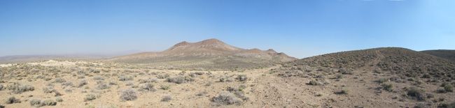
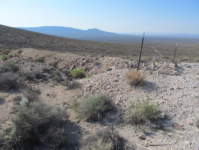
Bare Mountain lies along the northeast side of U.S. Highway 95 for about 1 S miles south of the town of Beatty in southern Nye County.,Nevada. Crater Flat, Yucca Mountain, and the Nevada Test Site lie to the east of Bare Mountain. The wide Amargosa Valley and the California border are to the southwest of Bare Mountain, and the Bullfrog Hills are located to the northwest, west of the town of Beatty. Bare Mountain stands out as an island of Paleozoic rocks, nearly surrounded by young volcanic rocks. It appears as a mass of older bedrock situated along the margins of the large caldera complexes that scallop it on its northern and eastern sides. Bare Mountain itself is an impressive but barren mountain mass composed mainly of colorful, zebra striped sedimentary rocks which are almost totally lacking in vegetative cover.
The first mining activity at Bare Mountain is credited to Mormons who found gold on the west slopes of Wildcat Peak on the southern tip of the mountain in about 1861. Ores were supposedly transported to the camp of Gold Center, on the Amargosa River south of present-day Beatty, for smelting (Carper, 1921). The present era of mining activity, however, dates back to early 1905 when gold was discovered on the northeast end of Bare Mountain (Lincoln, 1923, p. 167). Mercury was discovered in deposits on the northeast flank of the mountain in 1908, and the fluorite deposits in the north and east portions of the mountain were discovered in 1918 (Lincoln, 1923, p. 18). At Carrara, on the western side of the range, attempts were made between 1904 and 1936 to quarry marble for building material, but this activity never succeeded. The most recent mining and exploration activity in the range is centered around the Sterling gold mine where disseminated gold deposits were discovered in 1980.
GEOLOGICAL SETTING
Bare Mountain is composed almost entirely of late Precambrian and early to mid-Paleozoic sedimentary rocks that have been intensely deformed by folding and faulting. In general, Precambrian and Cambrian rocks crop out along the western slope and the southeast-trailing tail of Bare Mountain, while Ordovician through Mississippian formations make up the eastern half of the wide north end of the mountain mass. For the most part, the sedimentary rocks dip northward in successive blocks separated by right-lateral tear faults and flat thrusts (Cornwall, 1972, p. 31).
Some of the features mapped as thrusts may be alternately interpreted as gravity slide blocks and could be related to the collapse of the large caldera structures that border the Paleozoic bedrock of Bare Mountain. The area of lower relief, north of Bare Mountain and generally north of Fluorspar Canyon, is underlain by Miocene volcanic rocks. These volcanic rocks, which rim Crater Flat to the east as well, are highly faulted and consist largely of welded ashflow tuffs (Carr, 1982, p. 6). The ash-flow tuffs are interpreted by Carr 11982) as having two distinctly separate sources. The oldest tuff unit, Crater Flat Tuff, had as its source calderas in the area now occupied by Crater Flat.
This unit has been dated at 14-1 5 M.Y. (Christiansen and others. 1977. p. 947). The Crater Flat Tuff is overlain by the younger Paintbrush Tuff and Timber Mountain Tuff that are interpreted to have originated from the large Timber Mountain-Oasis Valley caldera complex which lies to the north of Bare Mountain (Carr, 1982. p. 8).
Altered rhyolite to rhyodacite dikes crop out generally along the eastern margin of Bare Mountain and cut across the narrow midsection of the range from northeast to southwest, transecting the Paleozoic bedrock. Carr (1982) reports a date of 13.9 m.y. for these dikes and states that they are the same age as lava flows that underlie the oldest Crater Flat Tuff unit. The dikes, in outcrop, form an arcuate pattern gently concave toward Crater Flat. Carr (1982) postulates that these dikes could represent outer ring dikes beyond the west wall of the Crater Flat collapse. Fluoriterich breccia pipes occur in conjunction with dikes at the Diamond Queen (Goldspar) Mine on the east edge of Bare Mountain, and the gold mineralization at the Sterling Mine occurs in an area cut by these dike rocks.


MINERAL DEPOSITS
Mineral deposits on and around Bare Mountain fall into two general categories: gold-base metal-quartz vein deposits hosted by Precambrian and Cambrian sedimentary rocks and gold-mercury-fluorite deposits that occur both in Cambrian sedimentary rocks and Miocene volcanic rocks.
The base-metal vein occurrences are scattered along the western slopes of Bare Mountain, and the gold and mercury occurrences are clustered in four general areas along the eastern and northern edges of the mountain. Gold-bearing quartz veins, high in base metals, occur in the west-draining canyons and along the western slopes of Bare Mountain. The veins commonly contain calcite as well as quartz, and they fill fault zones and shears that cut Precambrian-Cambrian quartzites, dolomites, and schists. The veins follow northeast, north-south, and some eastwest shears and faults. Veins on some properties are described as following thrust fault zones. Weak skarns, with associated tungsten mineralization, have been reported from two areas, the Silver Peak claims just north of Steves Pass and the Bonanza and Grand Junction claims in Tungsten Canyon. The metal sought at most of the properties in this area was gold, but silver, copper, lead, and zinc commonly provide the most visible minerals at the various properties.
ACCESS
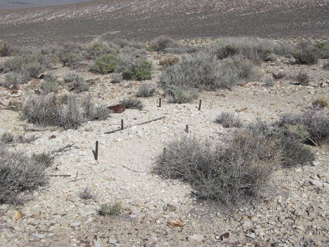
This entire area is relatively easily accessible by dirt roads which are well marked and well maintained. A 2-wheel drive car can get to this claim off of Route 95 via Beatty Wash Road, but I would recommend a good 4-wheel drive or even ATV’s to be able to access the entire claim that is not on the road. The area is full of dirt roads, so a good map and a good GPS unit is a must, but we'll show you exactly where it is on the map as well as provide you with the precise latitude and longitude of each corner marker, so finding it will not be a problem for you.


I advise caution whenever driving or hiking on this claim – the entire valley is dotted with abandoned mines – most of them are easy to see from a distance, but some of them are impossible to see until you are right on top of them. I would estimate that only 20% of them are roped or fenced off – the rest are wide open and you should be extremely careful if entering them. A couple of spare tires or an air compressor and patch kit or at least a couple of cans of tire sealant is strongly recommended for obvious reasons! Also, be sure to bring in whatever water you may need, as there are almost no water sources in the area 10 months out of the year.


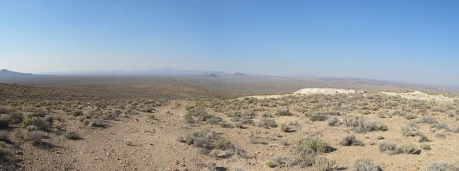
Note that all of the pictures of this claim were taken by the team and/or myself on a recent visit to this property.
All Pictures are of the actual property – no stock photographs were used


The federal government retains ownership of the land - so this means that you will not have any annual real estate taxes due on your mining claim, and you will not have to maintain liability insurance in case someone gets injured on your claim due to no fault of your own.
How do Transfers of Ownership in Mining Claims work if I decide to sell my claim in the future?
First, we handle all the paperwork and costs associated with transferring this claim into your name should you win this auction. But if you decide to sell this claim at some point in the future, interest in a properly recorded mining claim or site may be transferred (i.e sold) in part or its entirety. A quitclaim deed or recordable conveyance document is required and if you do sell your claim someday and the transfer documents should be filed within 60 days after the transfer.
We can and will help you with the paperwork for no cost should you need a hand selling your claim in the future if you pay all of the County, State and Federal fees (usually less than $40 to $60).Can you build / camp on your claim?
Without an approved plan of operations, you have the same rights and restrictions as the public. If the area is open to camping to the public, then it is permissible. However, you need to check with the BLM Field Office or the local District Ranger for areas open to camping. Under Federal law in order to occupy the public lands under the mining laws for more than 14 calendar days in any 90 day period, a claimant must be involved in certain activities that (a) are reasonably incident; (b) constitute substantially regular work; (c) are reasonably calculated to lead to the extraction and beneficiation of minerals; (d) involve observable on-the-ground activity that can be verified; and (e) use appropriate equipment that is presently operable, subject to the need for reasonable assembly, maintenance, repair or fabrication of replacement parts. All five of these requirements must be met for occupancy to be permissible.
Although it is possible to build a permanent structure on a mining claim, it is extremely expensive and you will have to jump through way too many hoops to consider it easy to do. It would have to be in support of a commercial, year-round mining operation for starters, and you would need to post a large reclamation bond to insure that if you ever abandoned your claim, the bond would pay for the removal of the structure and the reclamation or the area. So in short, it is technically possible to build on your mining claim, but just be aware that it is very difficult and expensive to do - however, camping is almost always involved unless your claim is in a wilderness area, which is not very common at all.
Proud Member of:
In addition to handling all of the paperwork to transfer this claim into your name, as well as paying all of the fees so you do not have any costs and we also pay all of the costs associated with mailing the paperwork to you as well as to the County and Federal Government for recording and sending you back certified copies.
We will ship you a folder with all paperwork, claim coordinates, maps and information on your claim, including a CD-Rom with all of the pictures of your claim upon your payment in full clearing. We ship everything to you the same business day (if payment is received by 1:00 PM Pacific Standard Time) - and we will always provide you with the tracking information so you are always informed.
You initial claim packet that we mail has an unrecorded deed so that you can show ownership immediately after payment and be able to visit your claim. A second original deed goes to the County for recording the same day, and a third original deed goes to the BLM for certification as well. Both of those originals will be returned to you so you will wind up with several original deeds - but the County and BLM deeds can take 3 to 6 weeks to be returned to you, which is why we send you the initial original on day one.
Your payment of this eBay item in full gives you 100% ownership of this entire claim, with no other fees and/or other costs for the transfer of ownership required. This is NOT an auction for the down payment, this is NOT a partnership arrangement where someone else will own part of the claim with you, and there are NO other fees or costs for the transfer of this claim in your name.
eBay does not allow checkout on the eBay website for any Real Estate transactions - simply because it is not like selling a widget - the transfer of real estate is complicated and requires notary work, licensed professionals and recording. Note that this is eBay’s rules and not ours and it is the same for any mining claim seller on eBay
We also are not able to accept PayPal payments for mining claims, as claims are real estate and PayPal does not allow payments to be made on any real estate items, including single family homes, condos, mining claim or land purchases. We DO accept just about every other kind of payment method you can think of: Personal Checks, Business Checks, Cashier's Checks, Money Orders, Bank Wires, ACH payments, Direct Bank Deposit at any Bank of America Branch, Gold or Silver Bullion (at the day’s SPOT prices), etc. After the auction close, we will send you a secure link to handle the payment safely online if you prefer, and we can also take care of payment by mail or telephone, as we are a traditional Brick and Mortar business - so whichever method you prefer is perfectly fine with us.
We provide financing plans with no interest or fees. Financing terms are minimum of $500 down with the balance will due within 90-days via three equal monthly payments of the remaining balance after the down payment has been paid.
With all financing plans, we do not transfer the final deed into your name until the claim has been paid in full. In the event of a default on a payment plan, we do not refund your down payment - however, we do allow you to put that down payment towards any other purchase as a store credit in full. If you are financing a climate and there is less than 90 days until September 1st (i.e. from June 1st through September 1st), when the annual fee for mining claims is due to the Federal Government, we will add the $165 maintenance fee to your down payment and pay it to the BLM on your behalf thereby increasing your down payment to $665 instead of $500 - however, the $165 portion of the down payment does not go towards your principle balance since it is used to pay the annual fees to the government, therefore the actual down payment credit will still be $500. Approval for financing is automatic as long as you have a valid eBay account in good standing.