Day & Section Hikes: John Muir Trail
by Kathleen Dodge Doherty, Jordan Summers
This updated book guides readers along the John Muir Trail's spectacular 211 miles, whether for a day hike, a few days, or the whole trail.
Paperback
English
Brand New
Publisher Description
Your section-by-section guide to the John Muir TrailDeclared one of the top five hiking trails on the planet by National Geographic Adventure magazine, the John Muir Trail runs a spectacular 211 miles from Yosemite Valley to the foot of Mount Whitney. e only way to experience this world-class trail is by foot, and Day & Section Hikes: John Muir Trail is here to guide you the entire way, whether you're out for a day hike, for a few days on a section hike, or for the entire trail.This handy guide includes:
- trail maps and elevation profiles
- ratings for scenery, difficulty, solitude, trail condition, and accessibility for children
- driving directions to trailheads and coordinates for GPS users
- permit and fee instructions as applicable
- details about what to expect on the trail
-Andrew Dean Nystrom, award-winning author of Top Trails: Yellowstone & Grand Teton National Parks"Doherty's insight makes for must-have reading."
-Tom Hale, founder of Backroads, the world's #1 active travel company
Author Biography
Kathleen Dodge Doherty first shouldered a backpack at the tender age of 10, when her dad forced her to walk around the neighborhood with a pack full of encyclopedias to prepare for her inaugural overnight outing in Yosemite National Park. From the first heavily laden step, a love affair was born, and a thirst for backcountry adventure has led Kathleen to decades of starry nights in her native California. Kathleen toasted her 30th birthday from the top of Mount Whitney after completing the John Muir Trail for the first time, and she has returned every summer thereafter. A graduate of the University of California, Berkeley, Kathleen has also had a career developing and leading hiking and biking trips around the globe, travel writing, and advocating for urban green space. She currently resides in San Francisco with her husband and two kids, where the steep inclines of Potrero Hill provide urban training for backcountry adventures.Jordan Summers has slept on more dirt, rock, and snow than any one person should be allowed. He commonly hears words of concern such as "that can't be good for you" and "what if," as well as some words of encouragement: "OK, lots of luck."
Table of Contents
Overview Map Map Key Acknowledgments Preface Recommended Hikes Introduction Day Hikes Yosemite National Park and Ansel Adams Wilderness Devils Postpile National Monument Sequoia National Park Section Hikes Yosemite National Park and Ansel Adams Wilderness Ansel Adams Wilderness and John Muir Wilderness John Muir Wilderness and Sequoia and Kings Canyon National Parks Suggested Packing List Emergency & First Aid Kit Contact Information Index About the Authors Map Legend
Long Description
The John Muir Trail runs a spectacular 211 miles from Yosemite Valley to the foot of Mount Whitney, crossing through Kings Canyon and Sequoia national parks, the Inyo National Forest, and the Devils Postpile National Monument. This guide has descriptions for six day hikes, five overnight hikes, and the entire trail in six sections, and includes transit and lodging information, altitude profiles, a GPS-based trail map, and ratings for scenery, trail condition, difficulty, accessibility for children, and solitude.
Excerpt from Book
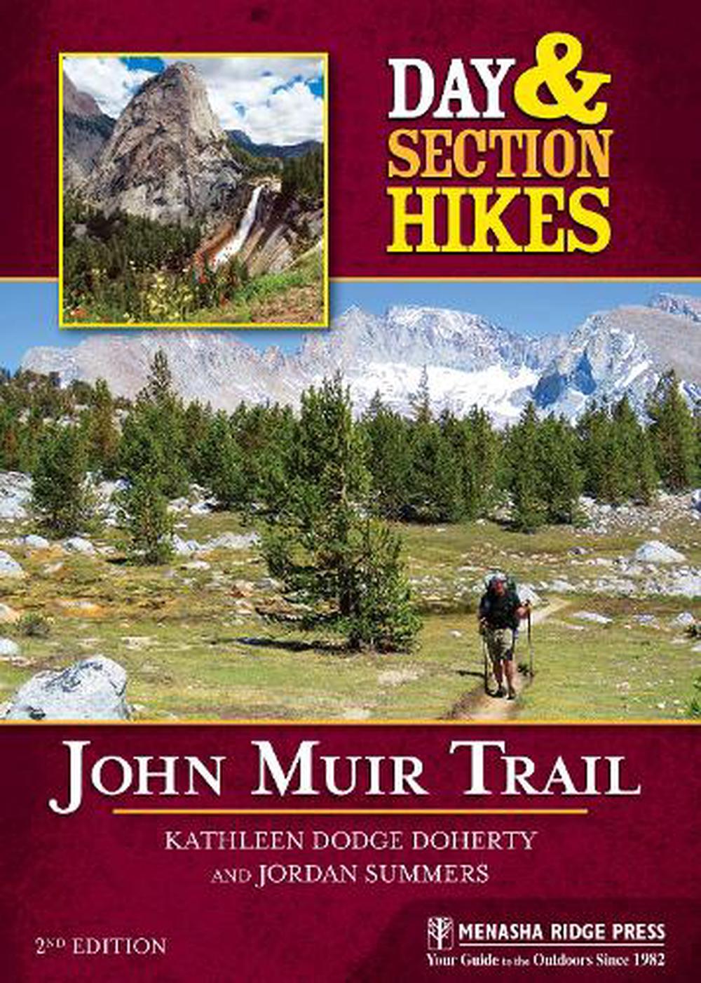
Vernal and Nevada Falls Scenery: ***** Trail Condition: **** Children: *** Difficulty: *** Solitude: * Distance & Configuration: 5.8-mile balloon Hiking Time: 4-6 hours Outstanding Features: Vernal Fall, Nevada Fall, Emerald Pool, Silver Apron, Clark Point, sweeping views of the valley A Yosemite classic, this one has it all: rushing waterfalls, verdant canyons, slabs of imposing granite, shady conifers, and inspiring views of the valley below. Nevada Fall drops 594 feet, making it the longest single leap of the Merced River, while Vernal Fall completes the journey with a 317-foot drop. The trail is no secret, but it''s hard to blame the masses once you witness its dramatic charm. Start this walk early before it''s overrun with valley-floor visitors, as well as to avoid midday heat in the summer. Beginning on the John Muir Trail (JMT), this is a balloon loop. Start by climbing to a scenic footbridge and a thunderous view of Vernal Fall. Next, continue up the Mist Trail to the top of Nevada Fall. To return, loop back, descending on the more gradual JMT to rejoin your route at the footbridge. From Happy Isles shuttle stop 16 (4,035''), walk along the road crossing the bridge over the Merced River, and then turn right to follow the river south along the dusty, well-defined path. Follow the path as it ascends rather steeply along the river canyon and around Sierra Point, a rocky ledge on the southwest ridge of Grizzly Peak named after the Sierra Club. This is a fitting beginning to your hike, as John Muir was the first president elected to this conservation body in 1892. This is a crowded path, and you may be as amazed at the impressive variety of footwear--and the diverse smattering of accents from around the world--as you are with the granite boulders and distant waterfalls. As you ascend, pass through and above Happy Isles''s woodland of conifers and live oak trees. Within 0.75 mile, reach your first viewing point of Vernal Fall. Together, Vernal and Nevada Falls are known as the Grand Staircase, as the Merced River dramatically steps its way down to the valley. Camera-toting tourists in flip-flops and bikini tops crowd a wooden footbridge located here (4,600''). Just across the bridge, look for a drinking fountain, restrooms, and an army of brazen snack-marauding squirrels. From this vantage point, you can see the final plunge of the Merced River, which collects winter runoff from Mount Lyell, Yosemite''s highest peak at 13,114 feet. Witness the dramatic cascade year-round as water thunders down amid a frame of pine and cedar trees. Shortly after leaving the footbridge, the trail reaches a junction. The Mist Trail continues on the left, following the river along a rock-lined path through an area of lodgepole pines. The official JMT turns to the right, taking a longer, more gradual climb before rejoining the shorter and steeper Mist Trail at the top of Nevada Fall. Follow the Mist Trail eastward upcanyon with a spectacular view of the waterworks cascading down. The route can be quite wet, especially in the spring and early summer, living up to its name with watery mist drenching hikers as they make their way up hundreds of steep and sometimes slippery granite steps. Many hikers don raincoats for this section of the trail, but on a hot day, the waterfall shower provides welcome relief. First reach the lower viewpoint of the falls, and then ascend the wet path upward, keeping your eyes peeled for rainbows in the spray. At the top of Vernal Fall, a rail protects you from the sheer drop, hopefully keeping you from losing your camera, your lunch, or your life. Vernal means "springtime," and the continual mist from the falls keeps the canyon lush and cool so that it''s perennially springtime in this corridor. Just upriver of the overlook lie the stunning wading pools and cascading waters of the Emerald Pool and Silver Apron, the latter so named for its color as a continual sheet of water streams over flat slabs of smooth granite. It''s tempting to slide down the Silver Apron or swim here, but the current is incredibly strong and history shows repeatedly that disaster (as in death) is assured for those who attempt it. But a foot soak, head dunk, and scenic snack are all highly encouraged. You will find some composting restrooms upriver from the pools, just off the trail to the right. Continue eastward and cross a wooden bridge over Diamond Cascade and then follow a relatively shaded gradual ascent, giving way to some exposed switchbacks in view of Nevada Fall. While the climb is steep up the rock walls, you have the prize in sight. Reach a juncture with solar composting toilets and a series of trails leading to Half Dome, Clouds Rest, and Tenaya Lake. For JMT thru-hikers, this is where the route continues toward Tuolumne. Turn right to follow the JMT southwest back toward the valley and reach a wide wading area. Before crossing the bridge, you can access an observation platform footbridge that allows you a glimpse into the river''s depths before it cascades violently over the edge. Many people miss this awesome overlook, which is worth a visit to really get a feel for the height. The iron-railed observation terrace is off a spur trail just north of the river. Nevada Fall flows through a narrow rock niche with tremendous force and then hits the wall, splitting into two different trajectories. After you''ve gotten your fill, rejoin the main trail and cross the wooden bridge (5,980'') to enjoy more dramatic views of the valley below. Descend toward the valley and continue on the main path, ignoring cross trails to Illilouette Fall. Descend gradually, sometimes along a moist canyon wall that provides a bit of a light shower in the early season. This whole route was blasted from the canyon wall, and it''s an impressive feat of modern engineering. When you reach Clark Point (5,481''), take in the views of the falls and the towering monoliths of the Liberty Cap, the back of Half Dome, and Mount Broderick. Stay left to follow the JMT down a series of steep switchbacks dotted with gnarled oak trees amid the granite. As you approach the river, keep right to stay on the foot trail as a stock trail descends to the left. As you near the river, turn left to follow the JMT back to the bridge, waterfalls, and bathrooms at the base of the falls, and return the way you came to the shuttle bus stop. PERMIT INFORMATION No permits are necessary for day hikes. DIRECTIONS See page 25 for directions to the Arch Rock Entrance of Yosemite National Park. The Happy Isles trailhead is in the southeastern part of Yosemite Valley, 1 mile past Half Dome Village (formerly known as Curry Village). From the Arch Rock Entrance, head 6.4 miles northeast on CA 140, then make a slight left onto CA 41 and continue 5.1 miles on Southside Drive. Continue straight as it becomes Happy Isles Loop, with the trailhead 0.5 mile farther on the left. Year-round, day hikers are encouraged to leave their cars in one of the day-use parking lots near Half Dome and Yosemite Villages and take the free shuttle bus to shuttle stop 16. The parking lot at Happy Isles is often full in the summer months. To reach the parking at Half Dome Village, follow the directions above, but turn right before Southside Drive turns into Happy Isles Loop. The parking will be on your right just after the curve in the road at 0.2 mile. To reach the day-use parking at Yosemite Village, follow the directions above to CA 41, and continue on Southside Drive 4.1 miles. Turn left onto Sentinel Drive, and in 0.3 mile turn right onto Northside Drive. The lot is on your right in 0.1 mile. GPS TRAILHEAD COORDINATES Happy Isles: N37
Details
