|
I t would take you over a year and a half to visit every mine in this book, even if you visited one mine a day, seven days a week.
This
first-edition, 154-page book describes and locates EVERY known
gold and silver mine (over 450 of them) in Shasta County, California.
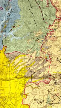 |
| Predict and find NEW gold deposits (and find existing mines) with Geologic map of Shasta County, showing mines and mineral deposits, a huge full-color map in rear pocket. Only small section of map is shown. |
|
The book is packed
with valuable geologic information, mine-production stats, history,
claimholders' names/addresses,
exact locations of mines and includes two big, separate maps in the rear
pocket (one in color).
Book
is in like-new condition
Want a trashed ex-library book, filled with scribbled notes, dog-eared
pages and highlighted passages? Want the large separate maps to be yellowed
and falling apart from being opened and closed 5,000 times? Then look
elsewhere. This first-edition report is in like-new condition.
Many of the mines
in this report are significant gold deposits. Mines and Mineral
Resources of Shasta County, California describes those rich deposits,
also detailing what rocks and minerals are gold indicators in lode and
placer deposits.
Not a gift-shop
tourist book
This hardcover report is not some gift-shop rockhound book; it was prepared
by the California Division of Mines and Geology some 27 years ago. It's
a treasure trove of information for history buffs, miners, bottle collectors,
photographers, rockhounds, hikers, geologists, prospectors, metal-detector
enthusiasts, stock certificate collectors, offroaders — just about
anyone interested in Shasta County's historic old mine sites (and working
ones too).
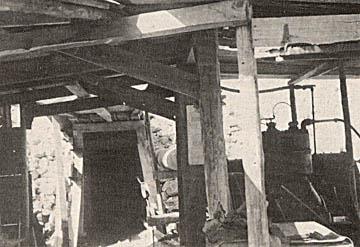 |
Portal of the lower adit of the Ajax gold mine, in Mad Ox Gulch north of Whiskeytown. |
|
Gives mine locations
in exact coordinates
How can you look for "color" in mine dumps or in Shasta County
streams if you don't know where the best dumps or the most productive
streams are? Don't waste weekends panning every
stream in the county or randomly digging through tailing piles for specimens.
This book gives exact locations, sometimes using landmarks, but almost
always using infallible range-and-township coordinates. Just plug
'em into your GPS or look 'em up on the appropriate topo, and you're there!
Okay, so you have
a book by a "noted rockhound" or an "ace prospector."
You might get lucky and find a couple of neat places, but you'll also
hit plenty of barren duds. Why? Because what rockhound, mine explorer
or prospector in their right mind would give away their favorite productive
locations? Not one.
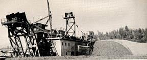 |
| Bucketline dredge of the Thurman Gold Dregding Company on Clear Creek south of Redding, October 1943. |
|
What they will
give you are directions to sites that are picked clean or second rate
at best. Don't rely on secondhand info when you can get it firsthand.
I guarantee that most — if not all — tourist-oriented rockhound
and prospecting books for Shasta County use
this 8.5-by-11-inch hardcover report as a prime source for information.
Want to pan or collect at virgin locations instead of ones already known?
Then you'll need to find new areas with geologic attributes conducive
to forming the minerals you're seeking. This sought-after book has that
information too (see map, top right). It was written about miners for
miners by miners.
Here are just
a few of the gold mines described:
- American mine,
about four miles northeast of French Gulch, credited with $300,000
production prior to 1914.
- Central mine,
near Redding, total production of $500,000 over life of mine, shut
down in 1919.
-
| We have many MANY more rare mining books! Just search for our ebay store, Rare Mining Books: http://stores.ebay.com/Rare-Mining-Books?_rdc=1 |
Midas, at Knob,
in Harrison Gulch, operated from 1896 to 1914, produced $3,563,587
in gold.
- Potosi (also
known as the Muletown Consolidated or Spring Gulch Mining Company),
near Igo; in Copley greenstone, vein consists of limonite-stained
quartz and free gold in the oxidized zone.
- Uncle Sam, near
Shasta Dam, one of the best known mines in Shasta County, credited
with production of $1 million; workings down to a maximum depth of
450 feet.
- Whiskey Hill (Tom Cook), near Whiskeytown, about 70 percent of production in free
gold — but the remainder in sulfides has never been recovered.
- Yankee John.
- B.H.K. Mining
Company, placer claim, Boulder Creek, Whiskeytown, bearing gravel
is 18 to 80 feet thick over entire claim.
- Plus, other
lode and placer prospects, large and small.
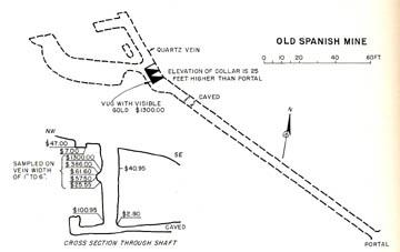 |
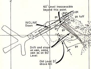
| Sketch map and cross-section of the Old Spanish mine. Gold assays are at lower left. |
|
Obviously, this
book also covers all manner of other Shasta County minerals: asbestos,
cadmium, chromite, lead, manganese, molybdemite, platinum (!!!), pyrite, quicksilver, silver
(!!!), tungsten, zinc, lots of iron and — of course — copper,
principally found in the belts that extend from Iron Mountain to Backbone
Creek.
Shasta copper mines have produced 703 million pounds of the stuff,
about 54 percent of all copper produced in California. Mines include the:
Balaklala, Bully Hill-Rising Star, Early Bird, Greenhorn (which also produced
$218,000 in gold and silver in 1939 alone), Iron Mountain, JCL, Mammoth
(which was worked for free gold in the 1900s before converting to a copper
mine), Shasta King and others.
Where is it?
Shasta County is in Northern California and surrounded by Del Norte,
Siskiyou, Modoc, Trinity, Tehama, Plumas and Lassen counties. Other
nearby counties include Humboldt, Mendocino, Lake, Glenn, Butte and
Sierra. Cities and towns in  Shasta:
Castella, Redding, Burney, McArthur, Fall River Mills, Shasta Lake City,
Redding, Shasta, Hat Creek, Shingletown, Anderson, Cottonwood and Platina.
Many of the mines in this book are near Redding. Rivers: Sacramento
and Fall. Shasta:
Castella, Redding, Burney, McArthur, Fall River Mills, Shasta Lake City,
Redding, Shasta, Hat Creek, Shingletown, Anderson, Cottonwood and Platina.
Many of the mines in this book are near Redding. Rivers: Sacramento
and Fall.
The book:
Mines and Mineral Resources of Shasta County, California
(cover at right), County Report 6, by Philip A. Lydon and J.C. O'Brien,
California Division of Mines and Geology, San Francisco, 1974, first
edition, 154 pages, 44 photos, two large oversized maps (one in full
color) folded in rear pocket, hardcover (very unusual for these
books), very good condition; looks like it rolled off the press yesterday,
except for very slightly soiled covers.
The fine print:
Feel free to contact me if you have any questions about the item or terms
of sale. Paypal only. I pride myself
on bulletproof packaging. I post feedback once a week
Not responsible
for typographical errors.
Good luck and thanks
for looking!!
 |
|
Tiny
detail of map from pocket: Yankee John gold mine, Shasta
County, California, section 17, T31 N R 5 W MDM, May 1959.
|
|