| First-edition
report & map describe forgotten One mine alone produced $900,00–$1million; another | ||||||||||
This first-edition report pinpoints little-known gold and silver mines in a remote section of Mojave Desert near the tiny town of Trona and the famous Panamint Valley, both in California.
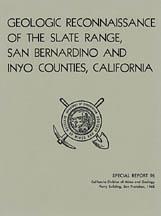
One mine alone produced between about $1 million! Geologic Reconnaissance of the Slate Range, San Bernardino and Inyo Counties, California — by four noted geologists — is not some gift-shop rockhound book. It was prepared by the California Division of Mines and Geology 35 years ago. It contains much valuable information for history buffs, bottle collectors, photographers, rockhounds, hikers, collectors of stock certificates, offroaders, metal-detector enthusiasts, prospectors — just about anyone interested in the California desert's geology, scenery or historic old mining sites. 4WD not needed Most of the mines are on federal land and not within the borders of Death Valley National Park, so prospecting and mineral collecting are allowed without any special permits or paperwork. But please check road conditions and current collecting rules before heading out into these areas. Road conditions and rules do change. Mines and prospects include:
Exact locations given Okay, so you have a book by a noted rockhound or an ace prospector. You might get lucky and find a couple of neat places, but you'll also hit plenty of absolute duds. Why? Because what rockhound, mine explorer or prospector in their right mind would give away their favorite productive locations? Not one. What they will give you are directions to sites that are picked clean or second rate at best. Don't rely on secondhand information when you can get firsthand info from this book.
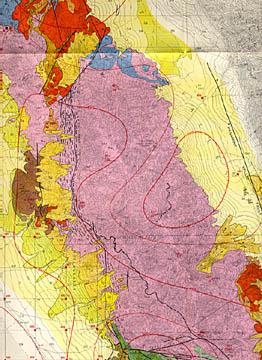
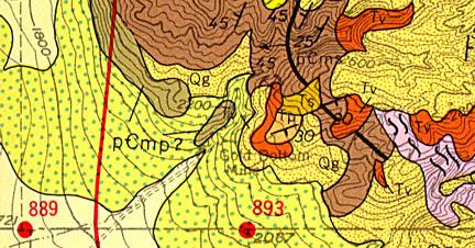
Want to prospect or collect at virgin, undiscovered locations instead of ones already known? Then you'll need to find new areas with geologic attributes conducive to forming the minerals that you're seeking. This book and map has that too (see two map details above). Who knows, maybe you'll discover the next Lost Burro gold mine.
Because this report also lists mine owners and different names for the same mine, it is also a valuable tool for collectors of stock certificates. Some mine descriptions contain brief histories of the mines in question (including dates of actual production) and previous owners. Book describes geology in detail Of course, the text contains far, far more detail about geology — especially how it relates to mineral deposits and their formations — than just the previous two paragraphs. Geology varies widely over an area the size of this quadrangle, so it is impossible to convey but the simplest geologic features in an ad.
Where is it? Perhaps, about a third of the Slate Range is located within the borders of China Lake Naval Weapon Center Range B, which is closed to the public. But the rest is on land controlled by the Bureau of Land Management (BLM), and open to mineral collecting and prospecting, subject to the usual BLM rules. Because it is near but not inside the new boundary of Death Valley National Park, strict national park rules against collecting do not apply. Nearest city of any size is Ridgecrest, about 40 miles away. Interestingly, some of the roads to mines in the Slate Range are plainly marked on the Auto Club of Southern California Death Valley road map, so that road map can be used easily to correlate some exact mileages to mines and other geologic features on the large color map from this report. Inyo County — the second largest county in the state — is in eastern California, bordering Nevada, about halfway between the Mexican border and Oregon. It includes the highest point in the contiguous United States (Mt. Whitney) and the lowest (Badwater). Counties adjacent to Inyo are Mono, Fresno, Tulare, Kern and San Bernardino. The book: As always, I am extremely conservative about rating book condition and very detailed in listing any potential flaw, no matter how slight. You get what you pay for. Look elsewhere on ebay, if you want a trashed book — filled with scribbled notes, dog-eared pages and underlined passages that the seller just "somehow forgot" to tell you about in his ad. The fine print: Paypal only. Free domestic shipping via priority mail. I pride myself on bulletproof packaging and ship in sturdy cardboard boxes or reinforced padded envelopes. I post feedback once a week Not responsible for typographical errors. Buy it now or forever hold your peace. Once it's gone; it's gone. Good luck and thanks for looking!! Nearby counties Towns, population areas and interesting sites in Inyo County include Aberdeen, the Alabama Hills, Ancient Bristlecone Pine Forest, Badwater, Ballarat, Big Pine, Bishop, Cartago, Cerro Gordo, China Lake Naval Weapons Center, Coso Junction, Darwin, Death Valley Junction, Dolomite, Dunmovin, Eureka Sand Dunes, Fossil Falls, Furnace Creek, Haiwee Reservoir, Independence, Keeler, Laws, Lake Sabrina, Little Lake, Lone Pine, Mt. Whitney, Olancha, Owens Lake, Panamint Springs, Pearsonville, Saline Valley, Scotty's Castle, Shoshone, Stovepipe Wells, Swansea, Tecopa and Ubehebe Crater. San Bernardino County cities and towns: Adelanto, Alta Loma, Apple Valley, Barstow, Big Bear Lake, Bloomington, Chino, Cima, Colton, Cucamonga, Essex, Etiwanda, Fontana, Forest Falls, George Air Force Base, Grand Terrace, Havasu Landing, Helendale, Hesperia, Highland, Hinkley, Lake Arrowhead, Loma Linda, Lucerne Valley, Mentone, Montclair, Morongo Valley, Mountain Pass, Mt. Baldy, Needles, Ontario, Oro Grande, Parker Dam, Phelan, Pinon Hills, Pomona, Rancho Cucamonga, Redlands, Rialto, Upland, Yermo, and Yucca Valley. |
 W. Troxel and Clifton H. Gray Jr., California Division of Mines and Geology; Roland von Huene, U.S. Naval Test Station geologist), California Division of Mines and Geology, San Francisco, CA, 33 pages, 8.5 by 11 inches. Stapled binding, stiff glossy covers. In fine, near-new condition; one large color map in pocket is folded with some slight rippling, otherwise in very good shape.