Your satisfaction is unconditionally guaranteed
Categories
- Bird's Eye Maps of US Cities
- Civil War Maps & Images
- United States Historical Maps
- Texas & Republic of Texas
- Europe & British Isles
- World Maps
- Asian/Eastern/African
- Science and NASA
- Novelty Maps & Posters
- Giclee Art Prints
- Subway & Railroad Maps
- Americas, Caribbean & Canada
- Nautical Charts
- CiA Maps
- Military & Aviation
- Astronomy & Zodiac
- Pacific, Australia & Poles
- Photographs & Drawings
- Feminism, Suffrage Etc.
- Other
Quebec, Canada; 1870 Johnson Map; Stunning Historic Cartography
Any quantity available.
Contact us for multiple prints!
- 16 X 24 or 24 X 36 inches
- 40.5 X 61 or 61 X 91.5 cm
This is a museum-grade reproduction of the version of A. J. Johnson 1870 map of Quebec and New Brunswick, Canada. It depicts the area in considerable detail with color coding according to county and district. Features the spirograph style border common to Johnson`s atlas work in 1870.
our item will look exactly like the product photos in this listing, including any white or textured borders.Everything is printed on easy-to-frame standard sizes, and we never crop or distort images.
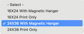
Hanger Optional
Type

Simply select option with hanger.
For a no-fuss, low-cost, handsome framing solution add a magnetic hanger! Assembling with no tools in a less than a minute, these hand-made hangers are made of the highest quality teak hardwood and super strong neodymium magnets. Fantastic for gifts!
Categories
- Bird's Eye Maps of US Cities
- Civil War Maps & Images
- United States Historical Maps
- Texas & Republic of Texas
- Europe & British Isles
- World Maps
- Asian/Eastern/African
- Science and NASA
- Novelty Maps & Posters
- Giclee Art Prints
- Subway & Railroad Maps
- Americas, Caribbean & Canada
- Nautical Charts
- CiA Maps
- Military & Aviation
- Astronomy & Zodiac
- Pacific, Australia & Poles
- Photographs & Drawings
- Feminism, Suffrage Etc.
- Other
Our Quality Process
We take quality seriously. Your item is custom printed on acid-free premium matte photo paper with archival inks. All items are printed just for you, one at a time, order by order. Unlike other sellers, we carefully restore each image digitally by eliminating major defects while preserving any minor marks or flaws that give these historic images charm.
Our Guarantee
If you are not completely happy with your purchase, simply return it for a prompt, full refund. Or, contact us and we will do our best to get you the poster you want.
Satisfaction Guaranteed
Shipping
All items shipped within one business day, USPS first class, free of charge. We carefully roll your poster and protect it in a rigid mailing tube.
Fast & free shipping
Payment
Paypal, credit and debit cards are all gratefully accepted.
