| Title: | “L'Amerique” | ||||||||||||
| |||||||||||||
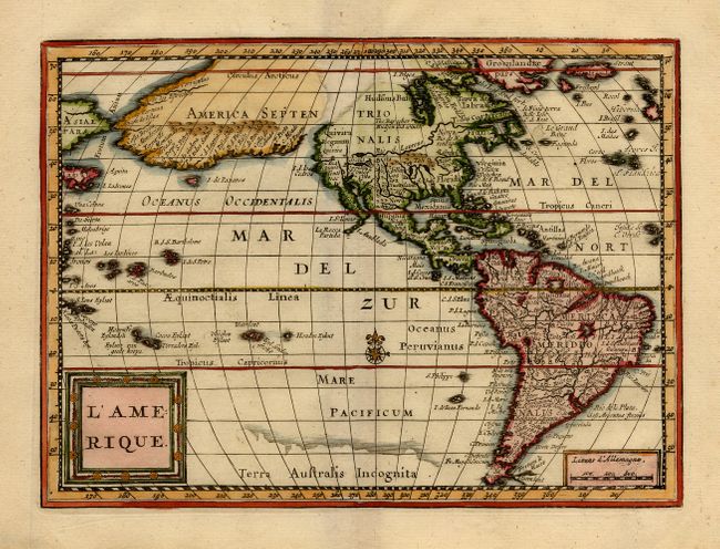
| Description: | The most dominant feature of this map of the Americas is the curious depiction of the west coast of North America, which is completely bisected by an unnamed straight (Northwest Passage), possibly derived from reports of Juan de Fuca's disputed voyage. The bulging northwest coast of North America continues another 65 degrees and is separated from Asia by a narrow Fretum Anian. Other interesting features include the St. Lawrence River flowing from a small lake in the West, no Great Lakes, and an area of shading in Virginia alluding to the possibility of a Verrazano-type inland sea. This is an extremely rare variant of Abraham Goos' map first published in Jansson's new Atlas Minor in 1628. For the Atlas Soulage the plate was revised with a square title cartouche (in French) and a scale replacing Goos' signature at bottom right. A small compass rose was also added in the Pacific. The atlas was only issued once and there is only one known complete copy extant, in the University Library of Leiden. | ||||||||||||
| Condition: | A+ | ||||||||||||
| References: | Burden #221, state 2. Originally purchased from Old World Auctions and comes with a certificate of authenticity. Please feel free to ask and questions and thanks for looking! Please read: Due to my work schedule, I can't ship the map until the Saturday after the map sells. | ||||||||||||