
Garmin ECHOMAP™ UHD 72cv
JOIN THE CLUB. FIND THE BEST FISHING SPOTS.
The chart plotter is equipped with a 7-inch touchscreen that is easy to read even in sunlight and a mounting bracket with quick release. The transducer bundle also offers an Ultra HD sonar and a traditional CHIRP sonar.
|
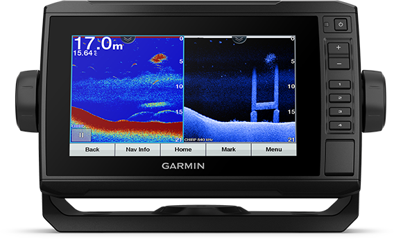
Get a detailed look under the boat with an optional transducer
|
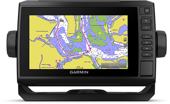
Navigate Allen waters with optional nautical charts
|
Share data with other devices on the network (7" and 9" models only)
|
Control your naval activities from almost anywhere on board
|
Control one of the most powerful electric motors for boats via the chartplotter
|
Create your own maps on board and customize the maps as you wish |
 |
|
|
|
SOUNDER ASSISTANCE
|
TRANSMITTER PACKAGE
|
BLUECHART G3 VISION NAUTICAL CHARTS
|
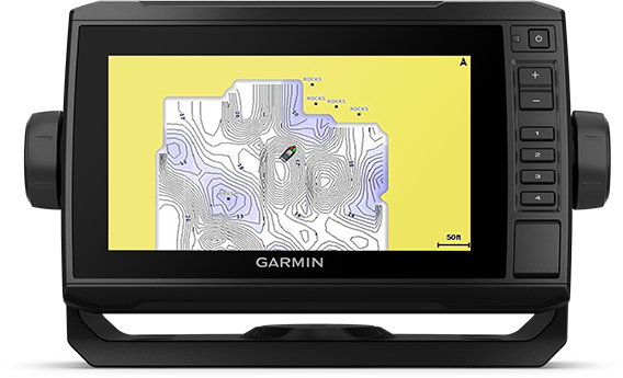
QUICKDRAW CONTOURS
|
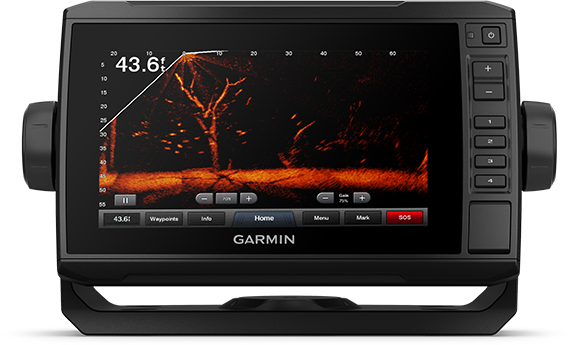
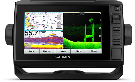
The chartplotter supports a variety of Garmin transducers (sold separately), including the Panoptix LiveScope™. Use it to view the conditions next to and under your boat in real time.
|
Choose the giver package and get the GT24 Transducer with Ultra-HD ClearVü sonar image. The transducer gives a very clear picture of the conditions under the boat. You also get traditional high-wide CHIRP sonar images with other detailed underwater structures. |
Count on excellent coverage and great detail thanks to the BlueChart® g3 Vision charts with integrated content from Garmin and Navionics® (optional).
|
Create your own fishing charts with depth lines of 30 cm (1 foot). Use the data yourself or share it with the QuickDraw™-Community via Garmin Connect™. |
 |
|
|
|
NETWORKABLE
|
NMEA 2000® AND NMEA 0183 NETWORKS
|
ACTIVECAPTAIN® APP
|
COMPATIBLE WITH THE FORCE™ TROLLING MOTOR
|
Do you have several compatible ECHOMAP UHD or ECHOMAP Ultra devices on board? Then share your sonar data, user data and charts across multiple screens (7" and 9" models only).
|
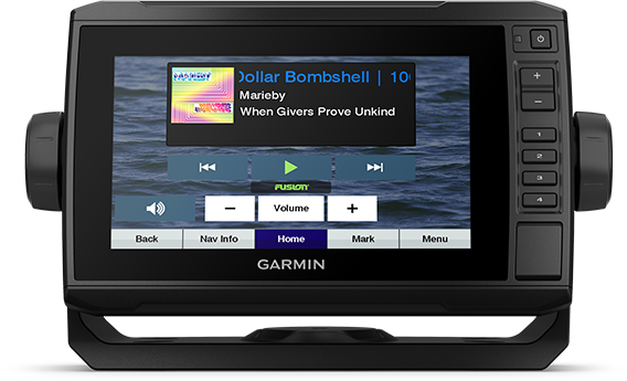
Connect to autopilots, digital switching, weather data, the FUSION link from one screen™-Audio system, media, VHF, AIS and more. |
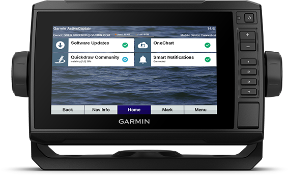
Simply connect the device to the mobile app via WiFi to access the OneChart™-Function, smart notifications1, software updates, data from the Garmin QuickDraw community, and more.
|
You can operate one of the most powerful and efficient electric boat motors2. Navigate to waypoints, follow tracks and more - all directly from your chartplotter.
|


Dimensions, weight & performance
| Display size, W x H | 15.5 x 8.6cm; 17.8 cm (7.0 inch) diagonal |
| power supply | 9 to 18 Vdc |
| Display resolution, W x H | 400x800 pixels |
| GPS | Yes |
| Dimensions | 25 x 13.9 x 5.1 cm |
| Built-in Receiver Hz | 5Hz |
| waterproofness | IPX7 |
| Weight | 0.77kg |
| mounting options | Bracket or flush mounting |
| display type | WVGA display |
Maps and navigation
| Data card support | 1 microSD™ memory card; maximum 32GB |
| Routes | 100 |
functions
| waypoints | 5 |
| sailing functions | Yes |
| NMEA 0183 compatible | Yes |
| Has built-in receiver | Yes |
| USB ports | no |
| TOPO | Yes |
| SideVü | no |
| Supports DSC (display of position data from DSC-capable VHF radio) | Yes |
| Touch screen | Yes |
| LakeVü g3 Ultra | Yes |
| Compatible with NMEA 2000® | Yes |
| Compatible with ActiveCaptain | Yes |
| Typical current draw at 12 Vdc | 0.8 A |
| NMEA 2000® ports | 1 |
| Tide tables with optional BlueChart chart | Yes |
| GLONASS | no |
| Track points | 50,000 |
| Panoptix™ all-seeing sonar | Yes |
| Garmin marine network connectors | 1 Panoptix™ connector |
| LakeVü g3 | Yes |
| Supports WAAS | Yes |
| Supports GSD™ black box sonar | no |
| Maximum current draw at 12 Vdc | 1.25A |
| Compatible with Garmin SmartMode (customizable screen presets) | no |
| suggested route | no |
| Maximum power usage at 10 Vdc | 15W |
| BlueChart® g3 | Yes |
| Standard Mapping® | Yes |
| LakeVü (domestic) | no |
| displays sonar | Yes |
| ANT+™ (Connectivity) | no |
| Supports GCV™ black box sonar | no |
| BNC external GPS antenna port | no |
| NMEA 0183 inputs | 1 |
| Spoken audio alerts | no |
| BlueChart® g3 Vision® | Yes |
| Garmin Wi-Fi® network (local connection) | no |
| Keyed assist buttons | Yes |
| Garmin Quickdraw™ Contours | Yes |
| Calls via bluetooth® | no |
| Supports AIS (tracking the position of the target boat) | Yes |
| 8-pin transducer ports | 1 |
| video outputs | None |
| Grid chart support | no |
| NMEA 0183 input (Tx) ports | 1 |
| OneHelm™ support | no |
| ClearVü | yes with CHIRP (built-in) |
| tracks | 50 saved tracks |
| Compatible with radio remote controls | Yes |
| Supports FUSION-Link™ compatible radios | Yes |
| Galileo | no |
| LiveScope | Yes |
| BlueChart® (coastal) | no |
| Traditional sonar (dual frequency/beam) | Yes |
| With GRID™ (Garmin remote input device) compatible | no |
| video inputs | None |
With giver
- ECHOMAP UHD 72cv with worldwide basemap
- GT24 UHD-TM encoder
- USB charge/sync cable
- Tilt/swivel mount with quick release
- Flush mount bracket
- Protective cover
- hardware
- documentation
Without giver
- ECHOMAP UHD 72cv with worldwide basemap
- USB charge/sync cable
- Tilt/swivel mount with quick release
- Flush mount bracket
- Protective cover
- hardware
- documentation

illustration if necessary deviating
All technical data are non-binding, errors excepted