Vintage Cartographics
Vermont Maps ∙ Antique Prints ∙ Bargain Bin ∙ Browse Nearby Sheets
1953
Irasburg
Vermont
USGS TOPOGRAPHIC MAP
1971 print in very good condition
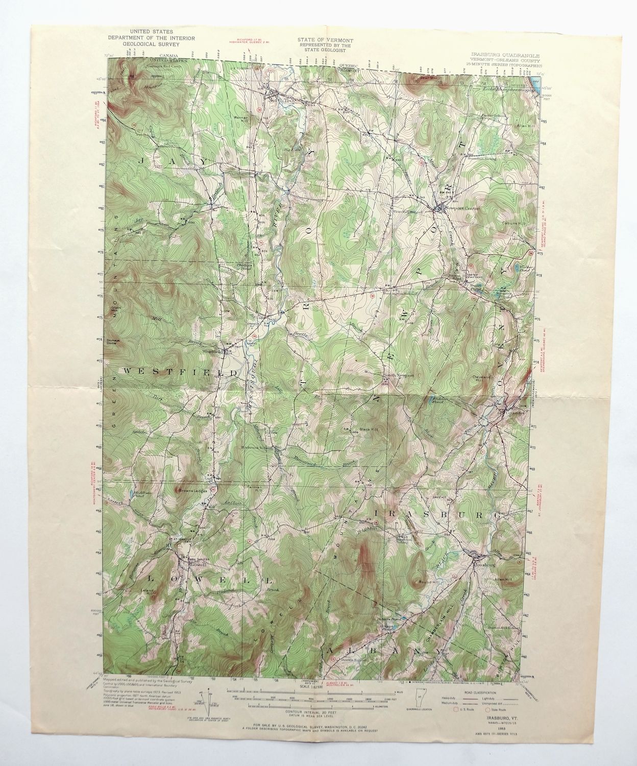
For sale is the 1953 edition of the Irasburg 15-minute map. This map would be ideal for framing or display, historical reference or research, genealogy studies, adding to your collection, treasure hunting, a nice conversation piece, a gift for a history or map enthusiast, or for anyone interested in this area. Maps of this vintage are printed on durable stock and are well-suited for outdoor activities and recreation of all kinds.
This sheet includes the first survey produced by the United States Geological Survey for the Irasburg 15-minute quadrangle. The map sheet is an original 1971 USGS print in very good condition.
The Irasburg 15-minute map shows all roads, paths, towns, railroads, rivers, creeks, elevation contour lines, public land survey lines, county, state, and other administrative boundaries as they existed at the time of the survey in 1923. A reddish tint may be used on this sheet to indicate urban areas where only landmark buildings will be shown. Outside of those areas, all known structures (houses, businesses churches, schools, barns, cabins, etc) are shown.
The Irasburg map was field surveyed before aerial photography methods were widely used in map data gathering. It was drawn by cartographers based on plane table field survey information as well as information gathered from local residents in the area. It displays the remarkable abilities of early government map makers, who placed a strong emphasis on creating complete, accurate, and cartographically appealing maps.
Maps from the 15-minute series for the continental United States are no longer produced or printed by the USGS and original prints are becoming increasingly difficult to find. They are a valuable historical record for an area, as they contain many placenames and features that have been dropped from more recent maps.
MAP DETAILS

Title
Irasburg
State
Vermont
Series
15-minute
Surveyed
1923 Field Survey
Edition
1953
Revision
1953
Printed
1971
Scale
1:62500
Contour Interval
20 Foot
Sheet Dimensions
16 1/2 x 20 inches (approximate)
Map Dimensions
12 3/8 x 17 1/2 inches
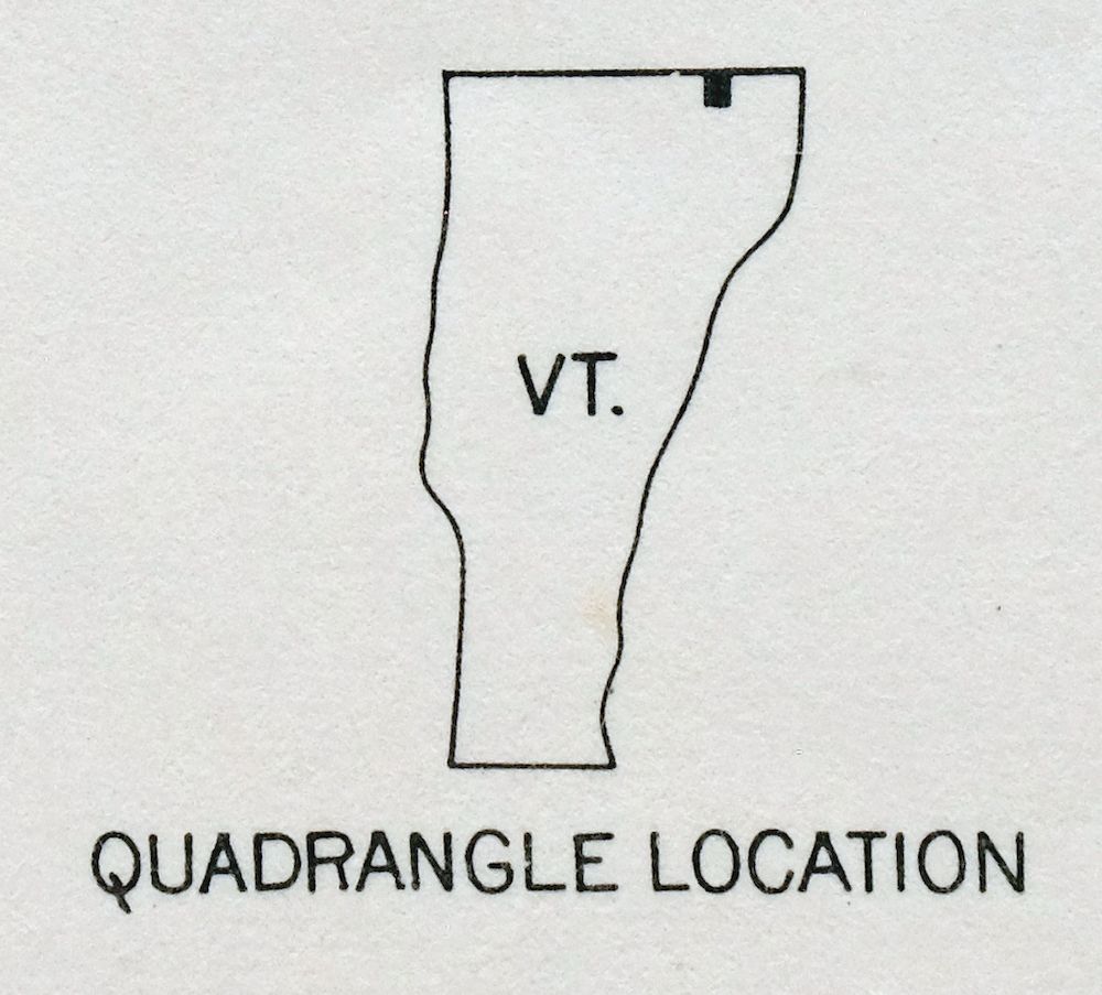
Coverage Area
12 x 17 miles
SHEET CONDITION
Overall Condition
VERY GOOD
Sheet Notes
lightly handled, midsheet horizontal and vertical foldlines
Map Area
no wear, no markings, minor age toning along some foldlines
Collar Area
no wear, no markings, no blemishes
MAP COVERAGE
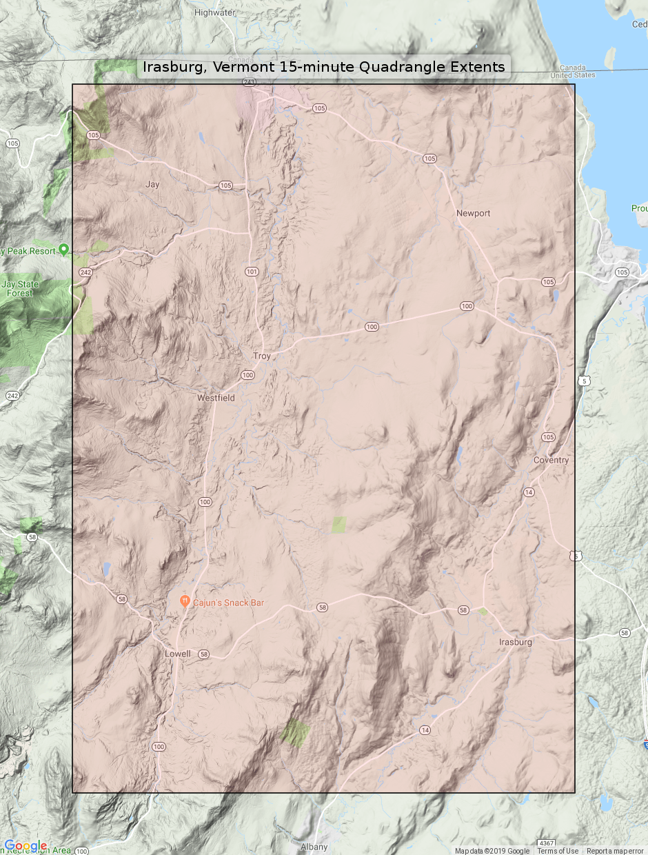
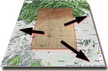
Quadrangle extent overlaid on current basemap.
PLACENAMES
Depending on map series and survey date, all of the features listed below may not be shown on this map. This list contains features that currently exist or historically existed within the area covered by this map. The list can be used as a reference to determine if this map covers your area of interest. Placenames are listed alphabetically next to each feature type.
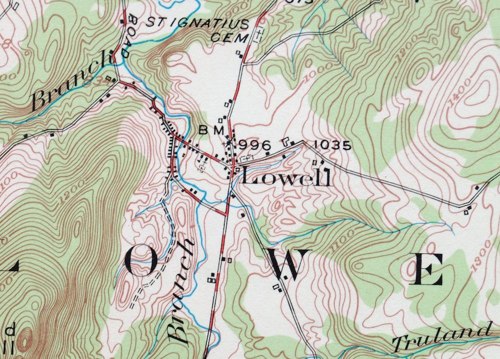
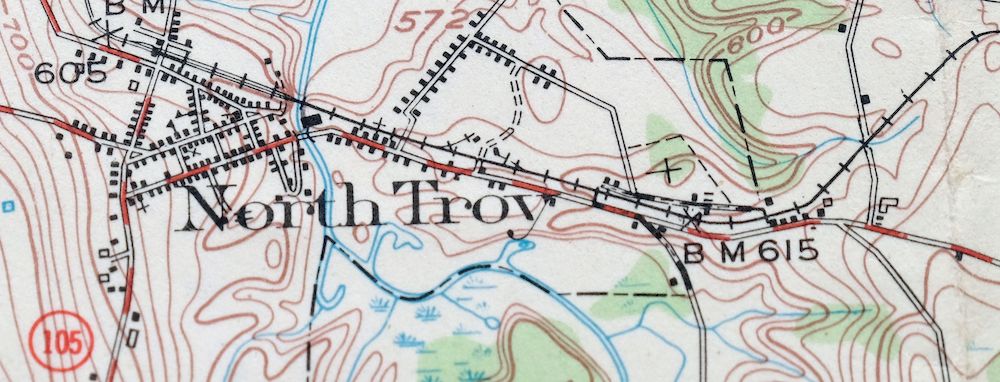
Cities and Towns (current)
Lowell and North Troy
Counties Covered
Lamoille and Orleans
Rivers and Streams
Ace Brook, Alder Brook, Allen Brook, Beetle Brook, Black River, Brighton Brook, Burgess Branch, Buybee Brook, Coburn Brook, Crook Brook, Dunn Brook, East Branch Missisquoi River, Jay Branch, Lamphean Brook, Le Clair Brook, Lilly Branch, Lords Creek, McCleary Brook, Mill Brook, Mineral Spring Brook, Missisquoi River, Mud Creek, Snider Brook, Taft Brook, Tamarack Brook, Truland Brook, and Ware Brook
Water Bodies
Griggs Pond, Kidder Pond, Lake Memphremagog, McAllister Pond, Lake Memphremagog, Phillips Pond, Potters Pond, Sargent Pond, Smith Pond, and Walker Pond
Locations: Summit Siding, Lowell Plain, and Mill Brook Campground. Administrative Boundaries: Town of Irasburg, Town of Jay, Town of Lowell, Town of Newport, Town of Troy, and Town of Westfield. Mountain Ranges: Lowell Mountains. Mountains, Peaks, and Summits: Stony Hill, Allen Hill, Black Hill, Browns Ledges, Burton Hill, Chamberlain Hill, Cleveland Hill, Coburn Hill, Farman Hill, Gilpin Mountain, Leland Hill, Round Hill, and Warner Hill. Parks: Irasburg Square. Drainages: Snider Brook, Stony Brook, Allen Brook, Ace Brook, Beetle Brook, Brighton Brook, Burgess Branch, Buybee Brook, Coburn Brook, Crook Brook, Dunn Brook, East Branch Missisquoi River, Jay Branch, Le Clair Brook, Lilly Branch, Lords Creek, Mill Brook, Mineral Spring Brook, Taft Brook, Tamarack Brook, Truland Brook, and Ware Brook. Churches: Federated Church, Federated Protestant Church, Grace Brethren Church, and United Church of Irasburg. Forests: Lowell Municipal Forest and Westfield Municipal Forest. Buildings: Leach Public Library and William H and Lucy F Rand Memorial Library. Waterfalls: Big Falls. Dams: Bakers Falls Dam. Bridges: Orne Covered Bridge and River Road Covered Bridge. Schools: Brighton School, Brown School, Burington School, Burton Hill School, Coventry Village School, Farrar School, Hitchcock School, Irasburg Village School, Jay-Westfield Joint School, Lowell School, Newport Town School, Troy Elementary School, and West Hill School. Reservoirs and Tanks: Sargent Pond, Smith Pond, Griggs Pond, Kidder Pond, McAllister Pond, Phillips Pond, Potters Pond, and Walker Pond.
SHIPPING AND RETURNS

This map sheet will be carefully rolled in a sturdy tube and shipped via the US Postal Service. Shipping and handling costs are included in the purchase price.
If you find that the sheet you receive is not as described in the listing, you may ship it back to us for a refund of the purchase price.
15~2849 15~2850 15~2851 15~2852 15~2853 15~2854 15~2855 15~2856 15~2857 15~3051 15~3052 15~3053 15~3054 15~3055 15~3056 15~3057 15~3253 15~3254 15~3255 15~3256 15~3257 75~10118 75~10119 75~10402 75~10403 75~10404 75~10405 75~10406 75~10407 75~10507 75~10508 75~10777 75~10778 75~10779 75~10780 75~10781 75~10782 75~11159 75~11160 75~11161 75~11281 75~9635 75~9636 75~9637 75~9638 75~9732 75~9733 75~9990 75~9991 75~9992 75~9993 75~9994 75~9995