Vintage Cartographics
Arkansas Maps ∙ Antique Prints ∙ Bargain Bin ∙ Browse Nearby Sheets
1946
Alexander
Arkansas
USGS TOPOGRAPHIC MAP
first-year print in very good condition
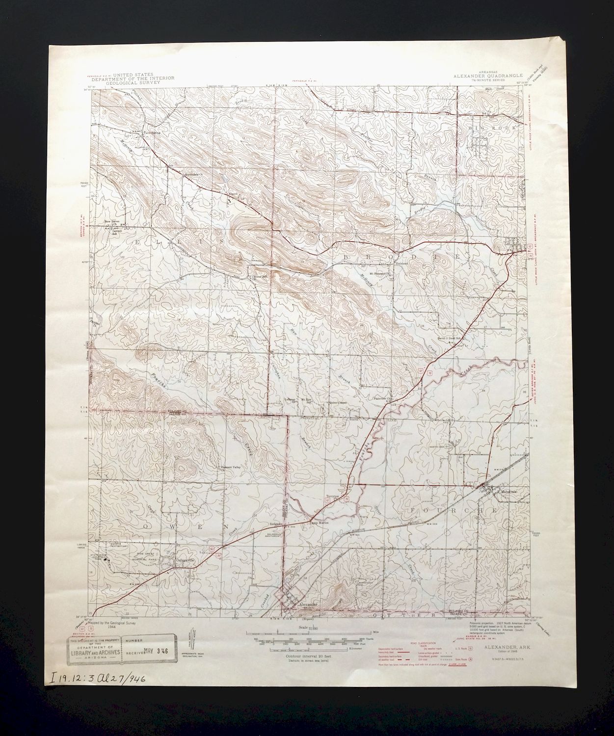
For sale is the 1946 edition of the Alexander 7.5-minute map. This map would be ideal for historical reference or research, genealogy studies, collectors, would make a nice conversation piece, a gift for a history or map enthusiast, framing or display, or for anyone interested in the area.
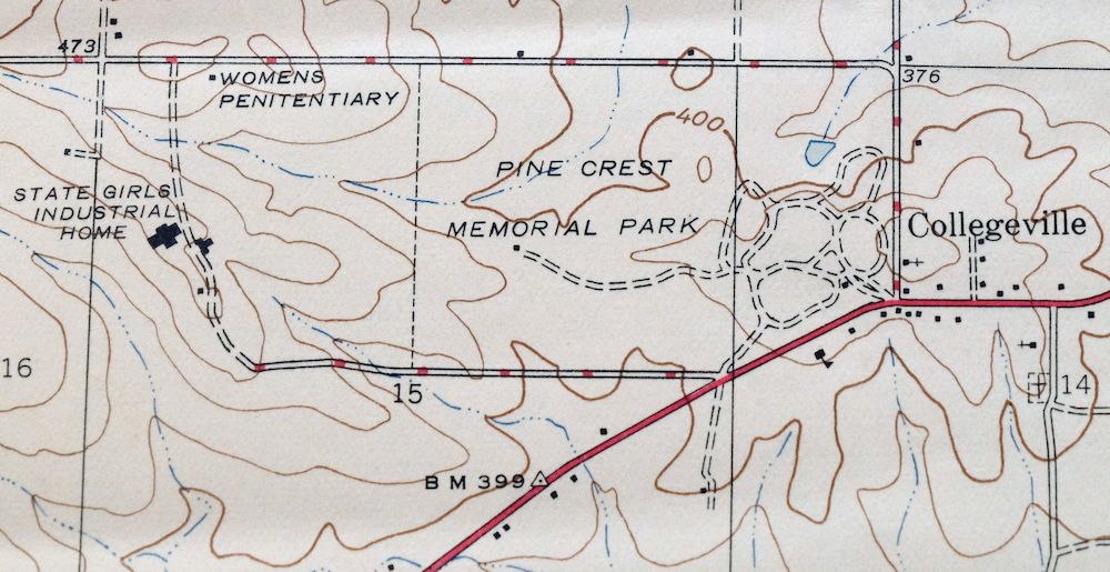
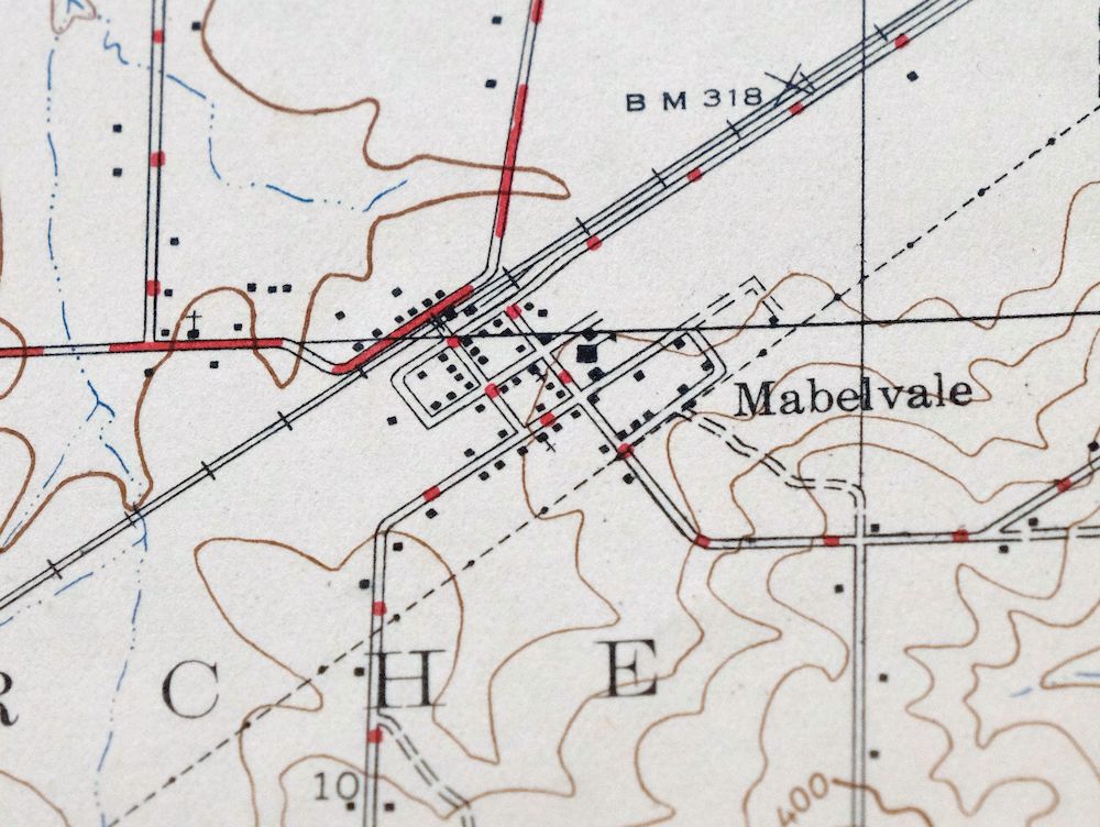
The Alexander 7.5-minute map shows all roads, paths, towns, railroads, rivers, creeks, elevation contour lines, public land survey lines, county, state, and other administrative boundaries as they existed at the time of the survey. All known structures (houses, businesses, churches, schools, barns, cabins, etc) are also shown.
The Alexander map was field surveyed before aerial photography methods were widely used in map data gathering. It was drawn by cartographers based on plane table field survey information as well as information gathered from local residents in the area. It displays the remarkable abilities of early government map makers, who placed a strong emphasis on creating complete, accurate, and cartographically appealing maps.
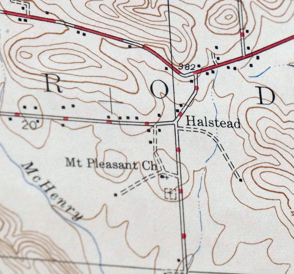
This map is from the 7.5-minute series, the most detailed series that is widely available from the USGS. The 1946 Alexander map is a valuable historical record for the area. It contains some placenames and features that have been dropped from more recent maps.
MAP DETAILS

Title
Alexander
State
Arkansas
Series
7.5-minute
Surveyed
1944 Field Survey
Edition
1946
Printed
1946, thick paper stock
Woodland Tint
No
Scale
1:31680
Contour Interval
20 Foot
Sheet Dimensions
17 x 20 7/8 inches
Map Dimensions
14 1/4 x 17 1/4 inches
Coverage Area
7 x 9 miles
Notes
fascinating historical snapshot of the far west and southwest suburbs of Little Rock, surveyed before the I-30 and the 430 Loop
SHEET CONDITION
For maps of this vintage, effort is made to note all visible flaws, no matter how minor.
Overall Condition
VERY GOOD
Sheet Notes
lightly handled, never folded
Map Area
flawless map area
Collar Area
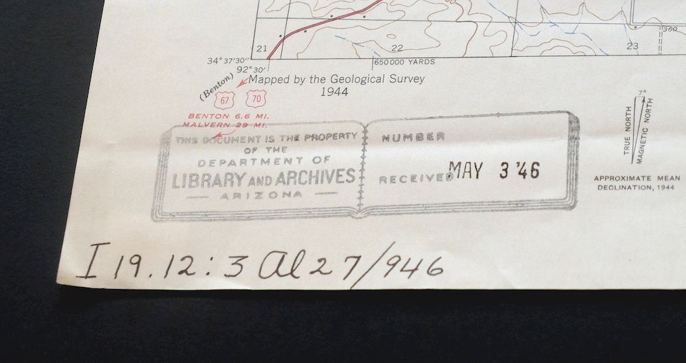
no blemishes, library notation and stamp in lower left collar, minor handling wear and stabilized edge tear in upper right collar
MAP COVERAGE
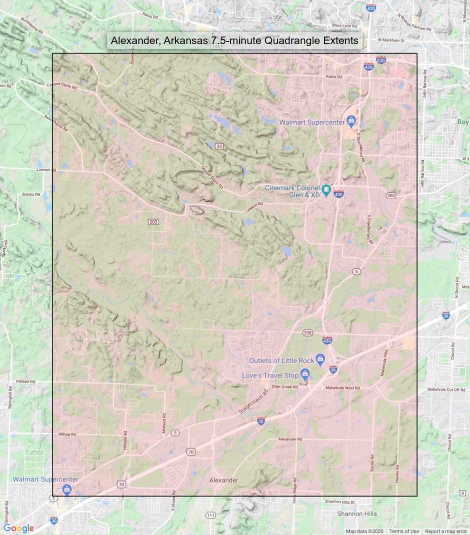
Quadrangle extent overlaid on current basemap.
PLACENAMES
Depending on map series and survey date, all of the features listed below may not be shown on this map. This list contains features that currently exist or historically existed within the area covered by this map. The list can be used as a reference to determine if this map covers your area of interest. Placenames are listed alphabetically next to each feature type.
Cities and Towns (current)
Alexander, Bryant, Little Rock, Mabelvale, and Shannon Hills
Counties Covered
Pulaski and Saline
Rivers and Streams
Brodie Creek, Callagahan Branch, Crooked Creek, Fletcher Creek, Fourche Creek, Haw Branch, Little Fourche Creek, McHenry Creek, Otter Creek, Owen Creek, Panther Creek, and Payne Branch
Water Bodies
Cecil White Reservoir, Coulter Lake, Gardner Company Lake, Koban Lake, Lake Florence, Lake Nixon, Lake Patricia, Second Edition Lake, Sprick Lake, Spring Lake, Tall Timber Lake, Twin Lakes, Ward Lake, and Wilson Lake
Locations: Aldersgate Camp, Benton Speed Bowl, and Mabelvale Industrial Park. Administrative Boundaries: Township of Brodie (historical), Township of Ellis (historical), Township of Fourche (historical), and Township of Owen. Valleys and Canyons: Crystal Valley. Parks: Little Oaks Park and Morehart Park. Drainages: Callagahan Branch, Crooked Creek, Haw Branch, McHenry Creek, Otter Creek, Owen Creek, Panther Branch, Panther Creek, and Payne Branch. Churches: Antioch Missionary Baptist Church, Bible Doctrine Church, Calvary Church of the Nazarene, Collegeville Church of the Nazarene, Crystal Hill Church, First Missionary Baptist Church of Mabelvale, Green Memorial Baptist Church, Heritage Baptist Temple, Hilldale Church, Hunter United Methodist Church, Labana Church, Mabelvale Church of Christ, Mabelvale United Methodist Church, Martindale Church, Mount Pleasant Church, New Commandment Evangelistic Church, New Haven Church, New Life Church, Oak Park Church, Otter Creek Church, Otter Creek First Baptist Church, Perry Street Missionary Baptist Church, Plainview Church, Quinn Chapel, River of Life Assembly of God Church, Rose Hill Church, Sardis Road Church, The Church of Jesus Christ of Latter Day Saints, Trinity Church, and Westwood Missionary Baptist Church. Hospitals: Baptist Medical Center and Southwest Hospital. Dams: Aldersgate Lake Dam, Gardner Company Lake Dam, Cecil White Lake Dam, Cook Lake Dam, Dailey Lake Dam, Florence Dam, Green Bear Lake Dam, Green Lake Dam, Jack Ward Lake Dam, Koban Lake Dam, Lake Nixon Dam, Lake Patricia Dam, Lower Spring Lake Dam, Sandpiper Lake Dam, Second Edition Twin Lakes Dam, Sprick Lake Dam, Spring Lake Dam, Spring Lake Number One Dam, Spring Valley Lake Number Two Dam, Tall Pine Lake Dam, Tall Timber Lake Dam, Twin Lakes Dam, and Wilson Lake Dam. Crossings: Interchange 1, Interchange 126, Interchange 128, Interchange 129, Interchange 130, Interchange 131, Interchange 4, Interchange 5, Interchange 6, Interchange 7, and Interchange 8. Airports: Garrett Landing Strip. Schools: Calvary Christian Academy, David O Dodd Elementary School, Heritage Christian School, J A Fair High School, Lawson Elementary School, Mabelvale Elementary School, Mabelvale Junior High School, Missionary Baptist Seminary, Otter Creek Elementary School, Romine Elementary School, and State Youth Service Center. Ridges: Ellis Mountain. Reservoirs and Tanks: Aldersgate Lake, Gardner Company Lake, Cecil White Reservoir, Cook Lake, Dailey Lake, Green Bear Lake, Green Lake, Koban Lake, Lake Alpine, Lake Florence, Lake Nixon, Lake Patricia, Lower Spring Lake, Sandpiper Lake, Second Edition Lake, Sprick Lake, Spring Lake, Spring Valley Lake Number One, Spring Valley Lake Number Two, Tall Pine Lake, Tall Timber Lake, Twin Lakes, Ward Lake, and Wilson Lake. Springs: Deleon Spring, Hernando Springs, and Two Springs.
BACKSIDE LEGEND
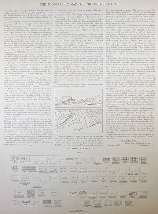
A map summary is printed on the back side of the Alexander sheet similar to the one shown in the picture. It outlines the history, purpose, and status of the USGS mapping program at the time of the printing in 1946. It also provides instructions on how to read contour lines and a description of how they are used to depict the terrain. At the bottom of the page is a legend showing all of the symbols used to represent the cultural, relief, and water features found on the map.
SHIPPING AND RETURNS

This map sheet will be carefully rolled in a sturdy tube and shipped via the US Postal Service. Shipping and handling costs are included in the purchase price.
If you find that the sheet you receive is not as described in the listing, you may ship it back to us for a refund of the purchase price.
15~10587 15~10772 15~10950 15~10951 15~10953 15~11129 30~2802 30~2803 75~41130 75~41131 75~41132 75~41133 75~41134 75~41488 75~41489 75~41490 75~41491 75~41492 75~41493 75~41494 75~41842 75~41843 75~41844 75~41845 75~41846 75~41847 75~41848 75~42200 75~42201 75~42202 75~42203 75~42204 75~42205 75~42206 75~42546 75~42547 75~42548 75~42549 75~42550