'Noricum, Vindelicie et Rhetie' (De L'Europe)
Original 17th century copperplate map, 1683
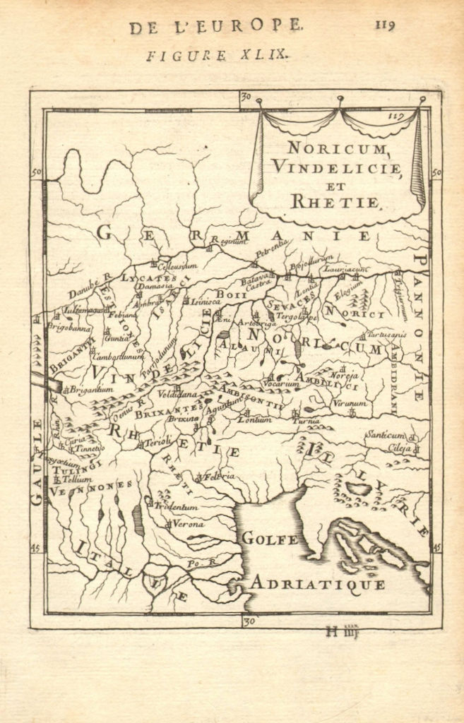
Title of the map: 'Noricum, Vindelicie et Rhetie'
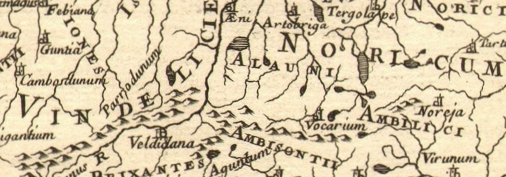
The image below shows an enlarged cross section from the centre of the map to show the level of printed detail:
The map runs from the North of the Adriatic to the Danube. Noricum is the Latin name for a Celtic kingdom, or federation of twelve tribes, including most of modern Austria and part of Slovenia. It became a province of the Roman Empire. It was bounded by the Danube to the north, Raetia and Vindelicia to the west, Pannonia to the east and southeast, and Italia (Venetia et Histria) to the south. In the pre-Roman Empire geography of Europe, Vindelicia identifies the country inhabited by the Vindelici, a region bounded on the north by the Danube and (later) the Hadrian's Limes Germanicus, on the east by the Oenus (Inn), on the south by Raetia and on the west by the territory of the Helvetii. It thus corresponded to the northeast portion of Switzerland, the southeast of Baden, and the south of Württemberg and Bavaria. Its chief town was refounded by the Romans as Augusta Vindelicorum ("Augusta of the Vindelici", or Augsburg). Raetia (so always in inscriptions; classical manuscripts usually use the form Rhaetia) was a province of the Roman Empire, named after the Rhaetian (Raeti or Rhaeti) people. It was bounded on the west by the country of the Helvetii, on the east by Noricum, on the north by Vindelicia, on the west by Cisalpine Gaul and on south by Venetia et Histria. It thus comprised the districts occupied in modern times by eastern and central Switzerland (containing the Upper Rhine and Lake Constance), southern Bavaria and the Upper Swabia, Vorarlberg, the greater part of Tirol, and part of Lombardy. Later Vindelicia, today south eastern Wuerttemberg and south western Bavaria was forming part of Raetia. The northern border of Raetia during the times of Augustus and Tiberius was the River Danube. Later the northern boundary was formed by the Limes Germanicus, stretching for 166 km north of the Danube. Raetia was linked to Italy across the Alps over the Reschen Pass, by the Via Claudia Augusta.
DATE PRINTED: 1683
IMAGE SIZE: Approx Overall page size 13 x 21cm approximately (5 x 8 inches); image size 10.5 x 14.5cm approximately (4 x 5.5 inches)
ARTIST/CARTOGRAPHER/ENGRAVER: Allain Manesson Mallet
PROVENANCE: "Description de l'Univers", contenant les differents systemes du Monde, les Cartes generales & particulieres de la Geographie Ancienne & Moderne: Les Plans & les Profils des principales Villes & des autres lieux considerables de la Terre; avec les portraits de Souverains qui y commandent, leurs Blasons, Titres & Livrees: Et les Moeurs, Religions, Gouvernements & divers habillemens de chaque Nation, dedieé au Roy, par Allain Manesson Mallet. Paris, Chez Denys Thierry, Rue S. Jacques, MDCLXXXIII (First edition, Paris, 1683)
TYPE: Original 17th century copperplate map
VERSO: There are images and/or text printed on the reverse side
CONDITION: Good; suitable for framing. However, please note: The image shown may have been taken from a different example of this map than that which is offered for sale. The map you will receive is in good condition but there may be minor variations in the condition from that shown in the image. Please check the scan for any blemishes prior to making your purchase. Virtually all antiquarian maps and prints are subject to some normal aging due to use and time which is not obtrusive unless otherwise stated. I offer a no questions asked return policy - see below.
AUTHENTICITY: This is an authentic historic print, published at the date stated above. I do not offer reproductions. It is not a modern copy. The term 'original' when applied to a print means that it was printed at the first or original date of publication; it does not imply that the item is unique. 'Print' means any image created by applying an inked block to paper or card under pressure by any method including wood engraving, steel engraving, copperplate, wood cut and lithography.
REMARKS: FRANCE: Gravures et Cartes anciennes. DEUTSCHLAND: Alte Lankarten und Stadt ansichten. ITALIA: Stampe e Mappe antiche. ESPAÑA: Mapas antiquos y impresiones antiguas. E and OE. Force Majeure. English law shall apply.
RETURNS POLICY: I offer a no questions returns policy. All I ask is that you pay return shipping and mail back to me in original condition, suitably packed & insured, within 14 days of receipt.