'Kincardineshire // North East view of Dunnotar Castle'
Antique early 19th century atlas map with original hand colouring, 1832
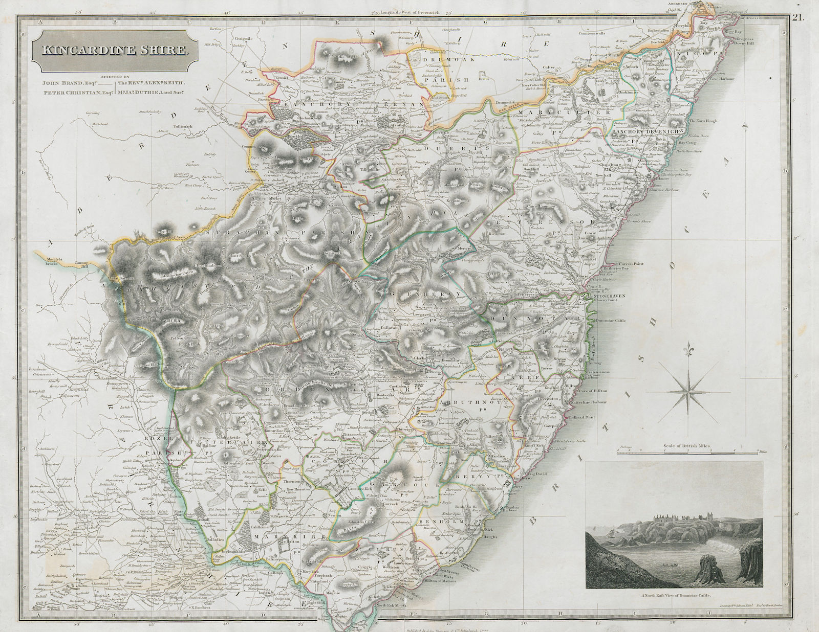
Title of map: 'Kincardineshire // North East view of Dunnotar Castle'
The image below shows an enlarged cross section from the centre of the map to show the level of printed detail. This map is folding hence the centrefold line may show on the image below:

Places named on the map include: Stonehaven, Aberdeen, Cove Bay, Portlethen, Inverbervie, Laurencekirk, Banchory
DATE PRINTED: Published 1832. The map was engraved in 1822 - this date is printed on the sheet.
IMAGE SIZE: Approx 53.5 x 69.5cm, 21 x 27.25 inches (Large); Please note that this is a folding map.
ARTIST/CARTOGRAPHER/ENGRAVER: Published by John Thomson. Drawn by W Johnson. Engraved by Hewitt. Attested by John Brand Esqr.; Peter Christian Esqr.; The Reverend Alexander Keith; Mr. James Duthie, Land Surveyor;
PROVENANCE: "The Atlas of Scotland containing maps of each county on a scale so large as to exhibit the features of the country and places of importance; the boundaries of the shires, attested with respectable names to verify their accuracy laid down from actual survey or compiled from plans of recent date, so as to form a complete body of topographical information at the date of publication.", printed for John Thomson & Co. Edinburgh; Baldwin & Cradock, London; and John Cumming, Dublin
TYPE: Antique early 19th century atlas map with original hand colouring
VERSO: There is nothing printed on the reverse side, which is plain
CONDITION: Good; suitable for framing. Please check the scan for any blemishes prior to making your purchase. Please contact us if you would like to arrange to view this map. Virtually all antiquarian maps and prints are subject to some normal aging due to use and time which is not obtrusive unless otherwise stated. I offer a no questions asked return policy - see below.
AUTHENTICITY: This is an authentic historic print, published at the date stated above. I do not offer reproductions. It is not a modern copy. The term 'original' when applied to a print means that it was printed at the first or original date of publication; it does not imply that the item is unique. 'Print' means any image created by applying an inked block to paper or card under pressure by any method including wood engraving, steel engraving, copperplate, wood cut and lithography.
REMARKS: FRANCE: Gravures et Cartes anciennes. DEUTSCHLAND: Alte Lankarten und Stadt ansichten. ITALIA: Stampe e Mappe antiche. ESPAÑA: Mapas antiquos y impresiones antiguas. E and OE. Force Majeure. English law shall apply.
RETURNS POLICY: I offer a no questions returns policy. All I ask is that you pay return shipping and mail back to me in original condition, suitably packed & insured, within 14 days of receipt.