[Plan of the Forts Ontario and Oswego, with part of the River Onondago and Lake Ontario]
Antique copperplate map, 1757
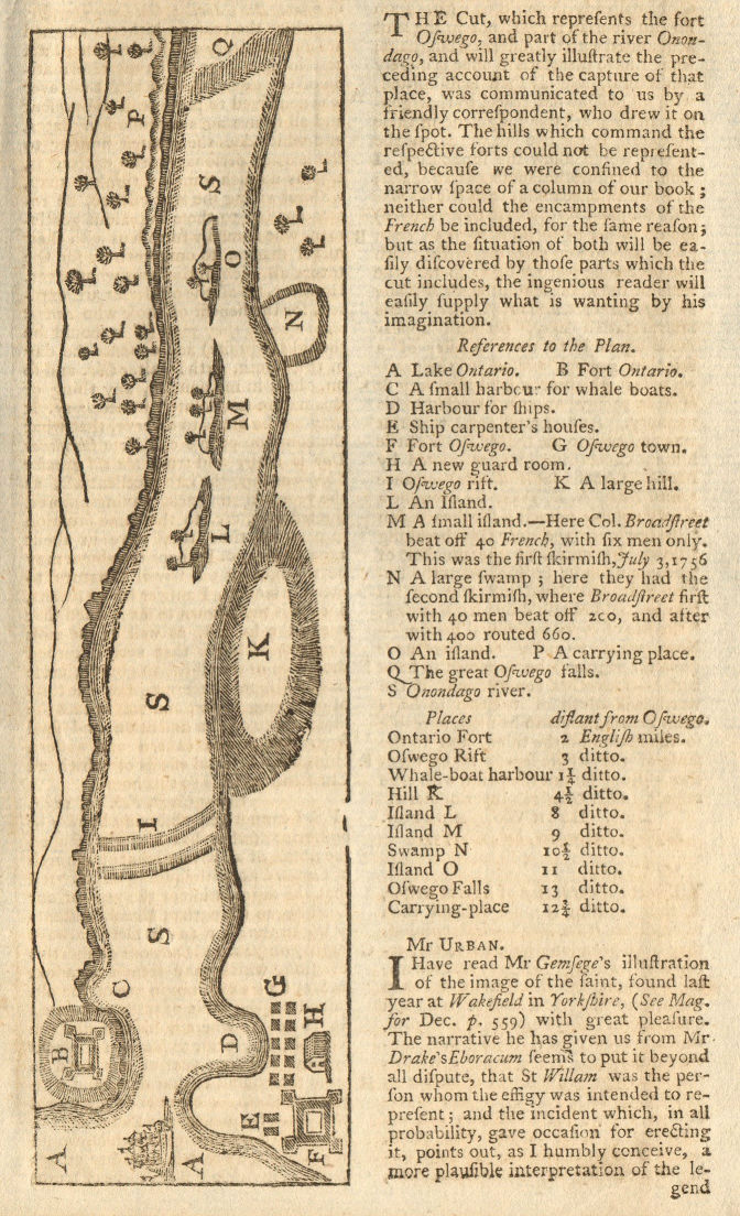
Title of map: '[Plan of the Forts Ontario and Oswego, with part of the River Onondago and Lake Ontario]'
Fort Oswego was an 18th-century trading post in the Great Lakes region in North America, which became the site of a battle between French and British forces in 1756 during the French and Indian War. The fort was established in 1727 on the orders of New York governor William Burnet. The log palisade fort established a British presence on the Great Lakes. In 1756 the fort's garrison of British soldiers were easily defeated by a combined French and Native American force. More than one hundred British soldiers were killed, many of them after the fort had been formally surrendered. The French took a further 1,500 British prisoners, and destroyed the fort itself. Fort Ontario is located on the east side of the Oswego River on high ground overlooking Lake Ontario. It was one of several forts erected by the British to protect the area around the east end of Lake Ontario. The original Fort Ontario was erected in 1755, during the French and Indian War in order to bolster defenses already in place at Fort Oswego on the opposite side of the river. At that time its name was the "Fort of the Six Nations," but the fort was destroyed by French forces during the Battle of Fort Oswego in 1756 and rebuilt by British forces in 1759.
DATE PRINTED: 1757
IMAGE SIZE: Approx 18.5 x 11.0cm, 7.25 x 4.25 inches (Small)
ARTIST/CARTOGRAPHER/ENGRAVER: Unattributed
PROVENANCE: "Gentleman's Magazine and Historical Chronicle", by Sylvanus Urban, Gent. London: Printed for D. Henry & R. Cave, at St. John's Gate
TYPE: Antique copperplate map
VERSO: There is text printed on the reverse side
CONDITION: Good; suitable for framing. However, please note: The image shown may have been taken from a different example of this map than that which is offered for sale. The map you will receive is in good condition but there may be minor variations in the condition from that shown in the image. Please check the scan for any blemishes prior to making your purchase. Virtually all antiquarian maps and prints are subject to some normal aging due to use and time which is not obtrusive unless otherwise stated. I offer a no questions asked return policy - see below.
AUTHENTICITY: This is an authentic historic print, published at the date stated above. I do not offer reproductions. It is not a modern copy. The term 'original' when applied to a print means that it was printed at the first or original date of publication; it does not imply that the item is unique. 'Print' means any image created by applying an inked block to paper or card under pressure by any method including wood engraving, steel engraving, copperplate, wood cut and lithography.
REMARKS: FRANCE: Gravures et Cartes anciennes. DEUTSCHLAND: Alte Lankarten und Stadt ansichten. ITALIA: Stampe e Mappe antiche. ESPA�A: Mapas antiquos y impresiones antiguas. E and OE. Force Majeure. English law shall apply.
RETURNS POLICY: I offer a no questions returns policy. All I ask is that you pay return shipping and mail back to me in original condition, suitably packed & insured, within 14 days of receipt.