'WORLD ON GNOMONIC PROJECTION, II., America'
Antique steel engraved map with original outline hand colouring (coloring), 1844
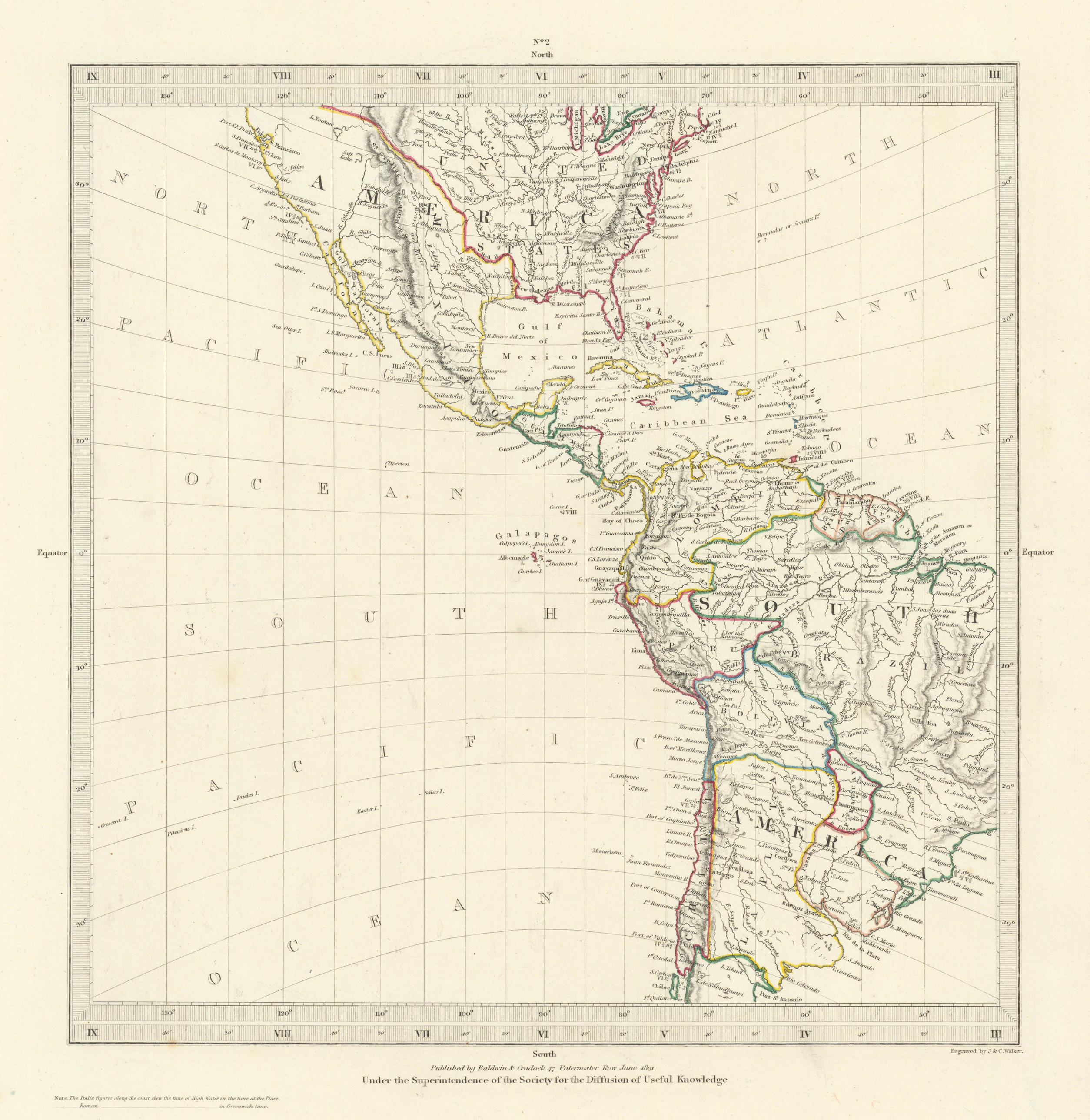
Title of print (not printed on the page):'WORLD ON GNOMONIC PROJECTION, II., America'
The national borders on the map have been drawn to show Texas as being part of Mexico. The map was originally engraved in 1831 (this date is marked on the map) prior to the Texas revolution which ended in the Texan declaration of Independence from Mexico 1836. The United States - Mexican border shown on the map follows that agreed under the 1819 Adams�Onis Treaty, being the Sabine River north from the Gulf of Mexico to the 32nd parallel north, then due north to the Red River, west along the Red River to the 100th meridian west, due north to the Arkansas River, west to its source, north to the 42nd parallel north, and finally west along that parallel to the Pacific Ocean.
DATE PRINTED: This map was originally published by Baldwin & Cradock in 1831; this date is printed on the map. This edition of the map published by Charles Knight in 1844, however the national borders on the map have been drawn to show Texas as being part of Mexico, suggesting either that the map was originally engraved prior to the Texas revolution which ended in the Texan declaration of Independence from Mexico 1836, or that the map was originally engraved during the period of the Texas Republic 1836-1845 and the mapmaker took the perspective of Mexico which had refused to recognise the independence of Texas. No date is printed on the map itself. The United States - Mexican border shown on the map follows that agreed under the 1819 Adams�Onis Treaty, being the Sabine River north from the Gulf of Mexico to the 32nd parallel north, then due north to the Red River, west along the Red River to the 100th meridian west, due north to the Arkansas River, west to its source, north to the 42nd parallel north, and finally west along that parallel to the Pacific Ocean.
IMAGE SIZE: Approx 30.5 x 28.5cm, 12 x 11.25 inches (Large)
ARTIST/CARTOGRAPHER/ENGRAVER: Engraved by J & C Walker
PROVENANCE: "Maps of the Society for the Diffusion of Useful Knowledge", published by Charles Knight, London, under the Superintendence of the Society for the Diffusion of Useful Knowledge [SDUK Atlas]
TYPE: Antique steel engraved map with original outline hand colouring (coloring)
VERSO: There is nothing printed on the reverse side, which is plain
CONDITION: Good; suitable for framing. Please check the scan for any blemishes prior to making your purchase. Virtually all antiquarian maps and prints are subject to some normal aging due to use and time which is not obtrusive unless otherwise stated. I offer a no questions asked return policy - see below.
AUTHENTICITY: This is an authentic historic print, published at the date stated above. I do not offer reproductions. It is not a modern copy. The term 'original' when applied to a print means that it was printed at the first or original date of publication; it does not imply that the item is unique. 'Print' means any image created by applying an inked block to paper or card under pressure by any method including wood engraving, steel engraving, copperplate, wood cut and lithography.
REMARKS: FRANCE: Gravures et Cartes anciennes. DEUTSCHLAND: Alte Lankarten und Stadt ansichten. ITALIA: Stampe e Mappe antiche. ESPA�A: Mapas antiquos y impresiones antiguas. E and OE. Force Majeure. English law shall apply.
RETURNS POLICY: I offer a no questions returns policy. All I ask is that you pay return shipping and mail back to me in original condition, suitably packed & insured, within 14 days of receipt.