|
HOLY ISLAND CASTLE
Artist: G.Balmer ____________ Engraver: H. Griffiths |
 Note: the title in the table above is printed below the engraving
CLICK HERE TO SEE MORE TOPOGRAPHICAL VIEWS OF ENGLISH COAST SCENERY LIKE THIS ONE!!
AN ANTIQUE STEEL ENGRAVING PRINTED IN THE EARLY 1840s!! VERY OLD WORLD! INCREDIBLE DETAIL!
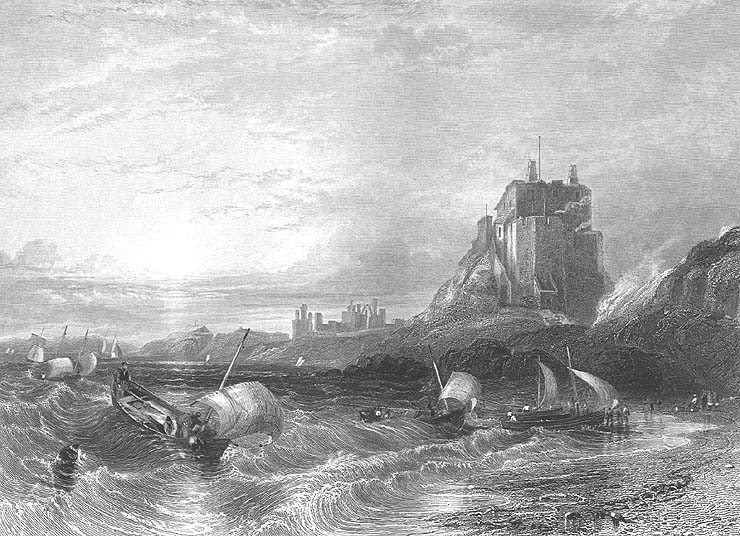
 In the present engraving the view is taken from the eastward on entering the harbour. To the right is the castle; beyond which, towards the centre of the view, are seen the ruins of the abbey. The setting sun sheds a warm, yet mellow light, over land and sea ; and as evening is approaching, and the breeze freshening with the flood tide-for it is evident from the inward swell that the tide is flowing-the fishermen are seen making for the shore. The boats bound merrily before the wind, and
"-the waves, that murmur in their glee,
All hurrying in a joyful band,
Come dancing from the sea."
The painter when he made his sketch must have thoroughly felt the beauty of the scene, and been touched with the influence of the hour:- "O Hesperus, thou bringest all good things!"
and inspirest poets to sing, and artists to paint the charms of eve's sweet hour in words and colours that never die-for once felt and communicated, they become impressed on the heart and soul of man, and live and bloom there for ever.
Holy Island, which is about two miles and a half long, and about two miles broad, lies off the Northumberland coast. On the south it is separated from the mainland by a deep channel about a mile broad. To the north-west it is connected with the mainland by a sand, which is dry at low water, and by which carts and passengers can pass to and from the island. Speed says that the Britons named it " Inis Medicante, for that, in manner of an island, it twice every day suffreth an extraordinarie inundation and overflowing of the ocean, which, returning unto her watery habitation, twice likewise makes it continent to the land, and laies the shoare bare againe, as before." It was called Lindisfarn by the Saxons; and in after times, from the celebrity of its monastery, and the holy men who had lived there, it acquired the name of Holy Island.
About 635, a church, of wood and thatched with reeds, was first built in Lindisfarn, by Aidan, a Scottish monk from the Isle of lona, who exercised the office of bishop in Northumberland. It was afterwards built of stone, and gave title to a bishop, until the see was removed to Durham In 995. The monastery continued as a cell, dependent on Durham, till it was suppressed by Henry VIII. A considerable part of the old church, with circular arches in what is termed the Saxon style, is yet standing, and forms, with the adjacent ruins, a most picturesque object. The village, or as it is usually called "the town," lies at a short distance to the northward of the ruins of the monastery, and is chiefly inhabited by fishermen, about two-thirds of whom are also licensed by the Trinity-house at Newcastle to act as pilots for their own harbour and the adjacent coast.
The fishery for cod, ling, and haddocis is usually carried on in cobles. These boats are very generally employed in the coast fishery from the Tweed to the Humber. They are sharp and wedge-shaped at the bow, but flat-bottomed towards the stern. They have only one mast, stepped close forward, on which a lug sail is set. They are excellent sea boats, and, for their size, carry a large sail. The usual length of a Holy Island coble is from twenty-five to twenty-seven feet, of which there are about sixty belonging to the island. A great quantity of the fish thus caught is sent to London in smacks, employed by fishmongers or salesmen there, who annually contract with the fishermen to pay them so much per score for all the fish sent during the season. From December to April many lobsters are caught off Holy Island, nearly the whole of which are sent to London. For the herring-fishery, boats of a larger size are employed. They are from thirty to thirty-six feet long, about eleven feet broad, and from four and a half to five feet deep. They carry two lug sails, and have no deck. The berring-fishery commences off Holy Island about the 20th of July, and usually terminates early in September. Many herrings are caught in the Fare-way, between the Farn islands and the main-land; but the principal fishery for them is generally a little to the southward of the Staples, a cluster of small islands which lie from two to three miles to the eastward of the Earns. Most of the herrings caught by the Holy Island fishermen are taken to Berwick to be cured, and are thence chiefly exported to London, Hull, and Newcastle.
On the beach to the westward of the island, the fossils called St. Cuthbert's beads the entrochi of naturalists-are found. They are also to be observed in the cliff to the north-east. A rock which lies at a short distance from the south-west point of the island is called St. Cuthbert's rock, where in former times superstition feigned that the saint was wont to sit and " - frame, The sea-born beads that bear his name."
This article of popular credulity has, however, been long exploded, and the fisherman when he hears the stones rattle on the beach from the force of the waves, no longer imagines that the sound proceeds from the saint's hammer.
In the present engraving the view is taken from the eastward on entering the harbour. To the right is the castle; beyond which, towards the centre of the view, are seen the ruins of the abbey. The setting sun sheds a warm, yet mellow light, over land and sea ; and as evening is approaching, and the breeze freshening with the flood tide-for it is evident from the inward swell that the tide is flowing-the fishermen are seen making for the shore. The boats bound merrily before the wind, and
"-the waves, that murmur in their glee,
All hurrying in a joyful band,
Come dancing from the sea."
The painter when he made his sketch must have thoroughly felt the beauty of the scene, and been touched with the influence of the hour:- "O Hesperus, thou bringest all good things!"
and inspirest poets to sing, and artists to paint the charms of eve's sweet hour in words and colours that never die-for once felt and communicated, they become impressed on the heart and soul of man, and live and bloom there for ever.
Holy Island, which is about two miles and a half long, and about two miles broad, lies off the Northumberland coast. On the south it is separated from the mainland by a deep channel about a mile broad. To the north-west it is connected with the mainland by a sand, which is dry at low water, and by which carts and passengers can pass to and from the island. Speed says that the Britons named it " Inis Medicante, for that, in manner of an island, it twice every day suffreth an extraordinarie inundation and overflowing of the ocean, which, returning unto her watery habitation, twice likewise makes it continent to the land, and laies the shoare bare againe, as before." It was called Lindisfarn by the Saxons; and in after times, from the celebrity of its monastery, and the holy men who had lived there, it acquired the name of Holy Island.
About 635, a church, of wood and thatched with reeds, was first built in Lindisfarn, by Aidan, a Scottish monk from the Isle of lona, who exercised the office of bishop in Northumberland. It was afterwards built of stone, and gave title to a bishop, until the see was removed to Durham In 995. The monastery continued as a cell, dependent on Durham, till it was suppressed by Henry VIII. A considerable part of the old church, with circular arches in what is termed the Saxon style, is yet standing, and forms, with the adjacent ruins, a most picturesque object. The village, or as it is usually called "the town," lies at a short distance to the northward of the ruins of the monastery, and is chiefly inhabited by fishermen, about two-thirds of whom are also licensed by the Trinity-house at Newcastle to act as pilots for their own harbour and the adjacent coast.
The fishery for cod, ling, and haddocis is usually carried on in cobles. These boats are very generally employed in the coast fishery from the Tweed to the Humber. They are sharp and wedge-shaped at the bow, but flat-bottomed towards the stern. They have only one mast, stepped close forward, on which a lug sail is set. They are excellent sea boats, and, for their size, carry a large sail. The usual length of a Holy Island coble is from twenty-five to twenty-seven feet, of which there are about sixty belonging to the island. A great quantity of the fish thus caught is sent to London in smacks, employed by fishmongers or salesmen there, who annually contract with the fishermen to pay them so much per score for all the fish sent during the season. From December to April many lobsters are caught off Holy Island, nearly the whole of which are sent to London. For the herring-fishery, boats of a larger size are employed. They are from thirty to thirty-six feet long, about eleven feet broad, and from four and a half to five feet deep. They carry two lug sails, and have no deck. The berring-fishery commences off Holy Island about the 20th of July, and usually terminates early in September. Many herrings are caught in the Fare-way, between the Farn islands and the main-land; but the principal fishery for them is generally a little to the southward of the Staples, a cluster of small islands which lie from two to three miles to the eastward of the Earns. Most of the herrings caught by the Holy Island fishermen are taken to Berwick to be cured, and are thence chiefly exported to London, Hull, and Newcastle.
On the beach to the westward of the island, the fossils called St. Cuthbert's beads the entrochi of naturalists-are found. They are also to be observed in the cliff to the north-east. A rock which lies at a short distance from the south-west point of the island is called St. Cuthbert's rock, where in former times superstition feigned that the saint was wont to sit and " - frame, The sea-born beads that bear his name."
This article of popular credulity has, however, been long exploded, and the fisherman when he hears the stones rattle on the beach from the force of the waves, no longer imagines that the sound proceeds from the saint's hammer.
PRINT DATE: This lithograph was printed in 1840; it is not a modern reproduction in any way.
PRINT SIZE: Overall print dimensions are 7 inches by 10 inches including a white border of approximately one inch on each side (not shown).
PRINT CONDITION: Condition is fine. Bright and clean. Blank on reverse.
BIOGRAPHY OF ARTIST: William Henry Bartlett, (born in London, 26 March 1809; died at sea off Malta, 13 Sept 1854) was an English artist most popularly known for his paintings of the Near East, Continental Europe and North America. He was a prolific artist and an intrepid traveller, with most of his work widely known through the numerous engravings made after his drawings and published in his own and other writers' topographical books. His primary concern was to extract the picturesque aspects of a place and by means of established pictorial conventions to render 'lively impressions of actual sights', as he wrote in the preface to The Nile Boat (London, 1849). His views of the major towns and coastal scenery of great britain were completed in 1840 & 1841 and show many of the resort towns, ports & harbours of the time. The interest in these engravings today is as much for the quality of the rendering and presentation of the architecture of the period as it is for the representation of the landscape & view.
SHIPPING:Buyers to pay shipping/handling, domestic orders receives priority mail, international orders receive regular mail.
We pack properly to protect your item!
Please note: the terms used in our auctions for engraving, heliogravure, lithograph, print, plate, photogravure etc. are ALL prints on paper, NOT blocks of steel or wood. "ENGRAVINGS", the term commonly used for these paper prints, were the most common method in the 1700s and 1800s for illustrating old books, and these paper prints or "engravings" were inserted into the book with a tissue guard frontis, usually on much thicker quality rag stock paper, although many were also printed and issued as loose stand alone prints. So this auction is for an antique paper print(s), probably from an old book, of very high quality and usually on very thick rag stock paper.
EXTREMELY RARE IN THIS EXCELLENT CONDITION!
|