|
HOLLAND
Artist: Plan Drawn and Engraved by John Rapkin, Illustrations by H. Warren and Engraved by J. B. Allen |
 Note: the title in the table above is printed below the engraving
CLICK HERE TO SEE MORE ANTIQUE MAPS AND PRINTS LIKE THIS ONE!!
AN ANTIQUE STEEL ENGRAVING MADE IN THE EARLY 1850s !! ITEM IS OVER 150 YEARS OLD!
VERY OLD WORLD! INCREDIBLE DETAIL!
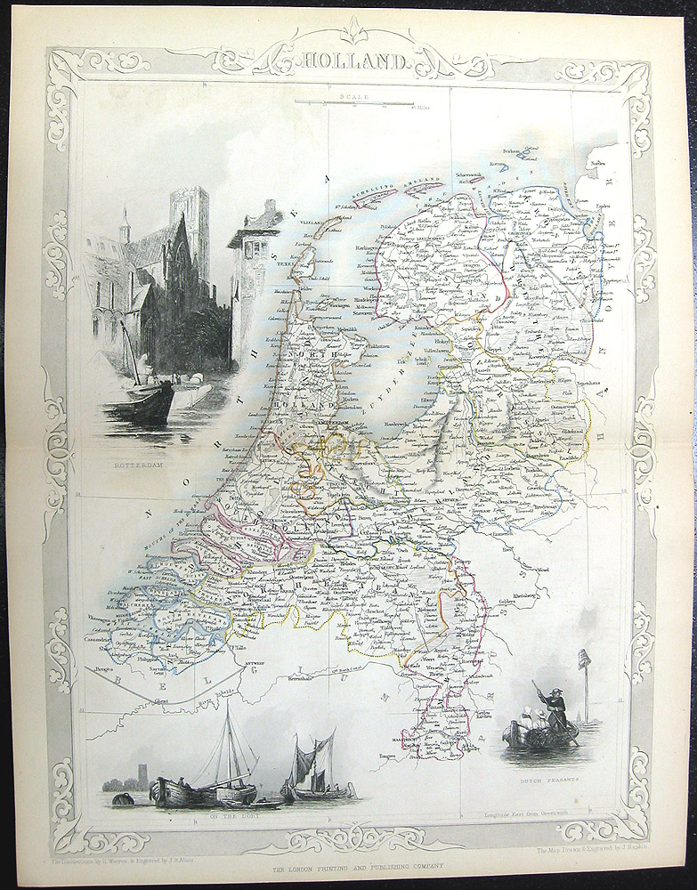
The Map shown here is a rare map engraved from the ILLUSTRATED ATLAS AND MODERN HISTORY OF THE WORLD Published by John Tallis in 1851. The engraved images show clockwise from top left, (1) ROTTERDAM (2) DUTCH PEASANTS, and (3) ON THE DORT. The map has folds where it was folded into the atlas. A DESCRIPTION OF THE MAP SUBJECT: The Netherlands is often referred to by the name Holland. This is not terminologically precise, since the provinces of North and South Holland in the western Netherlands are only two of the country's twelve provinces. The Netherlands is a densely populated and geographically low-lying country (its name literally means "low countries" or "low lands") and is popularly known for its windmills, clogs (wooden shoes), dikes, tulips, bicycles and social tolerance. Its policies are liberal towards drugs, prostitution, same-sex marriage, abortion and euthanasia. The country is host to the International Criminal Tribunal for the Former Yugoslavia, the International Court of Justice and the International Criminal Court at The Hague. Holland arose as a county of the Holy Roman Empire in the 9th century. The counts of Holland were also counts of Hainaut, Flanders and Zeeland for several periods in the 13th-15th centur day. In 1432, Holland became part of the Burgundian Netherlands, and after 1477 of the Habsburg Seventeen Provinces. In the Eighty Years' War (1568-1648), the northern Dutch provinces, including Holland, successfully broke away from Habsburg-Spanish rule. Holland became the most prominent and prosperous part of the United Provinces. The formation of the Batavian Republic, inspired by the French revolution, led to a more centralized government. The dominance of Holland was reduced by an administrative reform in 1798, in which its territory was divided over several departments: Amstel, Delf, Texel, and (part of) Schelde en Maas. During the French occupation (1810-1813), Holland was divided over the départements Zuyderzée and Bouches-de-la-Meuse. After 1813, Holland was restored as a province of the Netherlands. It was divided into the present provinces North Holland and South Holland in 1840. A remarkable aspect of the Netherlands is the flatness of the country. Hilly landscapes can be found only in the central part, the south-eastern tip of the country and on the edge of the Ice-age, where the glaciers pushed up several hilly ridges such as the Hondsrug in Drenthe, the stuwwallen near Nijmegen and the Utrechtse Heuvelrug.About half of its surface area is less than 1 metre (3.3 ft) above sea level, and much of it is actually below sea level. An extensive range of dykes and dunes protects these areas from flooding. Numerous massive pumping stations keep the ground water level in check. The Netherlands is divided into twelve administrative regions, called provinces, each under a Governor, who is called Commissaris van de Koningin (Commissioner of the Queen), except for the province Limburg where the commissioner is called Gouverneur (Governor) which underlines the more "non-Dutch" mentality. Fryslân - north west; capital and largest city Leeuwarden Groningen - north east; capital and largest city Groningen Drenthe - south of Groningen; capital Assen, largest city Emmen Overijssel - east central, south of Drenthe; capital Zwolle, largest city Enschede Flevoland - central, north of Utrecht; capital Lelystad, largest city Almere Gelderland - east central, south of Overijssel; capital Arnhem, largest city Nijmegen Utrecht - central; capital and largest city Utrecht North Holland - (Noord-Holland) north west; capital Haarlem, largest city (of the province and the country) Amsterdam South Holland - (Zuid-Holland) west central, south of North Holland; capital The Hague ('s-Gravenhage or Den Haag), largest city Rotterdam Zeeland - south west; capital and largest city Middelburg North Brabant - (Noord-Brabant) south central; capital 's-Hertogenbosch (or Den Bosch), largest city Eindhoven Limburg - south east; capital and largest city Maastricht.
SIZE: Print size is 14 inches by 11 inches.
CONDITION: Condition is excellent, as shown in this large detailed scan. Blank on reverse side. Printed on heavy old rag stock paper.
SHIPPING: Buyers to pay shipping/handling, domestic orders receives priority mail, international orders receive regular mail.
Please note: the terms used in our auctions for engraving, heliogravure, lithograph, print, plate, photogravure etc. are ALL prints on paper, NOT blocks of steel or wood. "ENGRAVINGS", the term commonly used for these paper prints, were the most common method in the 1700s and 1800s for illustrating old books, and these paper prints or "engravings" were inserted into the book with a tissue guard frontis, usually on much thicker quality rag stock paper, although many were also printed and issued as loose stand alone prints. So this auction is for an antique paper print(s), probably from an old book, of very high quality and usually on very thick rag stock paper.
EXTREMELY RARE IN THIS EXCELLENT CONDITION!
|