9.7 SAMSUNG TAB A TABLET CHARTPLOTTER..
FULL 2024 OVER 800 RASTER UK CHARTS FULL KIT.ANDOID 6-7.1
STAND HAS THE OPTION OF FIXING THE HOLDER BAR BY GLUE.SCREW/BOLT OR THE CLAMPS...MUCH LESS WOBBLE...DOESNT BREAK OFF AS THE SUCTION ONES CAN DO.
FULL SET OF 2024 LICENCED AND LEGAL UK CHARTS..GREAT DETAILED COVERAGE,
NON GOOGLE PLAY O.E.M. LATEST MARINE NAVIGATOR LICENCED APP INSTALLED WITH THE CHARTS.SOFWARE MANUAL IS INCORPORATED IN HELP WHEN YOU OPEN MARINE NAVIGATOR.A SHORT DEMO VIDEO IS PUBLISHED BY US ON YOU TUBE....SEARCH LONDONCHARTPLOTTERS.
A FEW FREE MARINE APPS INSTALLED F.O.C,,EG WEATHER/GRIB/ETC. SOME OF THESE REQUIRE A INTERNET CONNECTION.MARINE NAVIGATOR,THE NAV APP DOES NOT..
3
THIS IS A FULL TURNKEY SET...YOU COULD OPEN THE PACK ON THE BOAT AND GO SAILING.
THIS DOES NOT NEED INTERNET/SIM/WIFI TO NAVIGATE..IT USES GPS AND GLONAS SATTELITES...FREE... TO GET YOURE POSITION...ACCURATE TO WITHIN A COUPLE OF METERS MAX.
NO ANNUAL CHARGES..EVERYTHING PAID FOR AND UP AND RUNNING.CHARTS DO NOT STOP WORKING.NO DOWNSIDE.NO CATCHES.
UNPACK THIS ON THE BOAT AND YOU WILL BE FINE!!!!!
ALL COVERED UNDER OUR "IN HOUSE" (NO SENDING OFF) 6 MONTH GUARANTEE.EXTENDABLE TO 12 MONTHS FOR 20.00
EVEN IF YOU BREAK IT...WELE FIX IT HERE.UNDER GUARANTEE OR NOT..AT A PRICE THAT MAKES SENCE...EG SCREEN REPLACE 50.00 .SCREEN COSTS US 42.00
WE DO NOT CHARGE LABOUR FOR REPAIRS IF IT IS OUR DEVICE.ONLY COSTS.
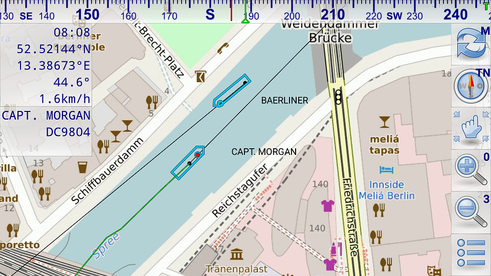
* automatic chart switching depending on current position and zoom level
* scrolling through all charts available for the current location by "press and hold" zoom buttons
* display of number of available charts for current location in the zoom buttons
* display of outlines of installed charts in active chart
* chart rotation (True North, True Course, Compass Heading, original chart orientation)
* tracks, way points, routes
* follow route automatically
* intuitive route editor
* gpx import and export of waypoints and routes
* gpx export of tracks
* recording of tracks in active and standby mode
* length of recorded tracks only limited by the capacity of the external storage (SDCARD)
* compass (magnetic north, true north)
* different dashboard layouts (basic data, detailed route data, detailed GPS data including graphical status info)
* Man Over Board (MOB) functions"
Our favourite feature so far Being able to point the tablet at the bows, "Compass Up", and having the "True Course Line" switched on. This show as a dotted line stretching ahead the CMG by the boat. So "at a glance" the navigator can see how much the current is having an effect on the boat at that instant. (Or leeway for that matter).
The "Compass Up" feature also allows you to positively identify buoys or seamarks from a distance, by lining them up with the tablet/phone.
Note: Not ALL Android devices have a built in compass.