


We started with the X-Star in 2015 and firmly established our role as an industry-leader with the EVO series. The development of the EVO II platform in 2020 marks a new era for Autel Robotics as we adapted, refashioned, and accelerated technologies to meet the intended applications of these dynamic aircraft and payloads for their purpose-driven users.


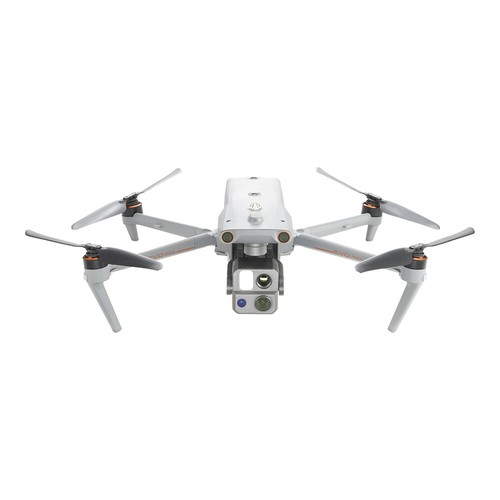
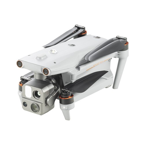
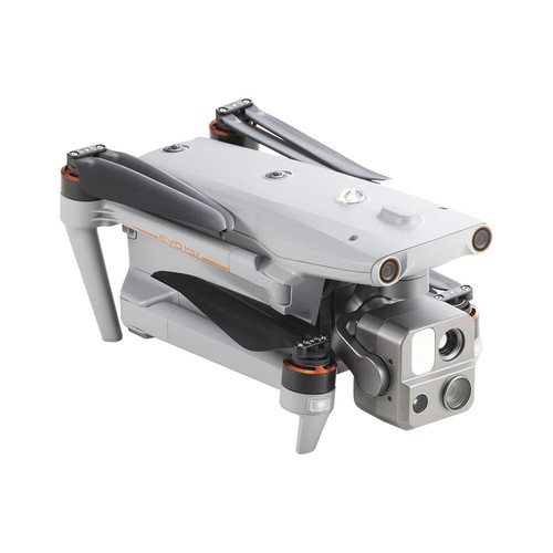
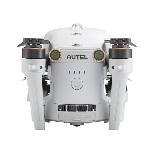
Autel Robotics EVO Max 4T 8K Drone with Smart Controller V3 Laser Range Finder

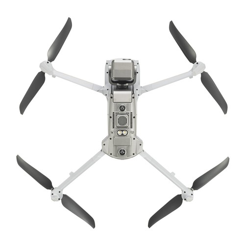


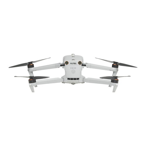


Erreichen Sie neue GrenzenDer Autel EVO Max 4T bringt leistungsstarke Technologien und fortschrittliche Autonomie für professionelle Drohnennutzer. Der EVO Max 4T bewertet komplexe Umgebungen, um in Echtzeit 3D-Flugpfade für eine beispiellose Hindernisvermeidung zu erstellen. Hochentwickelte Sensoren ermöglichen Flüge in Gebieten, in denen kein GPS verfügbar ist, und die unglaubliche neue thermische Nutzlast eröffnet neue Szenarien zur Objektidentifizierung und -verfolgung. Mit seinem faltbaren, wetterfesten Design ist der Autel EVO Max 4T ebenso tragbar wie leistungsfähig. |
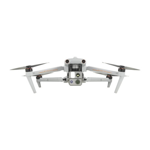
Hybrid-Sensor-Nutzlast Die EVO Max 4T-Nutzlast integriert eine Weitwinkel-, Zoom- und Wärmebildkamera mit einem Laserentfernungsmesser für alle Datenerfassungsanforderungen und kritische Entscheidungen. Laser-Entfernungsmesser Wärmebildkamera Weitwinkelkamera Zoom-Kamera  |
Führend in der Drohnen-Intelligenz
Autonome Wegfindung Navigation in Umgebungen, in denen kein GPS verfügbar ist Genaue Objektidentifizierung und -verfolgung  |
Keine blinden Flecken EVO Max 4T ist die einzige kommerzielle Drohne, die traditionelle binokulare Sichtsysteme mit Millimeterwellen-Radartechnologie kombiniert. Dadurch kann die integrierte Autonomie-Engine des EVO Max 4T Objekte bis zu einer Tiefe von 0,5 Zoll wahrnehmen, was tote Winkel eliminiert und den Betrieb bei schlechten Lichtverhältnissen oder Regen ermöglicht. *Die OA-Leistung hängt von der Geschwindigkeit der Drohne, den Lichtverhältnissen und den Flugbedingungen ab und soll die Verantwortung des Piloten nicht ersetzen.  |
Anti-Stau, Anti-Interferenz Das Autel EVO Max 4T verwendet fortschrittliche Flugkontrollmodule und Algorithmen, die speziell entwickelt wurden, um RFI, EMI und GPS-Spoofing zu verhindern. Dadurch kann der EVO Max 4T sicher in der Nähe von Stromleitungen, kritischen Strukturen und in komplexen Gebieten fliegen. |
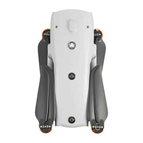
Plattform-Fähigkeit Das EVO Max 4T definiert mit seiner leistungsstarken Plattform und seinem wetterfesten Design die Tragbarkeit neu. Sie ist mit den folgenden Merkmalen und Fähigkeiten ausgestattet: *Start und Landung können Windgeschwindigkeiten von bis zu 12 m/s (27 mph) standhalten.  |
A-Mesh 1.0 - Mesh-Vernetzungstechnologie
Starke Anti-Interferenz Anwendungen jenseits der Sichtlinie Kontrolle der gesamten Flotte Erhöhte Reichweite |
Autel SkyLink 3.0 Das Autel EVO Max 4T SkyLink 3.0-System ist mit 6 Antennen, 4 Frequenzbändern, AES-256-Verschlüsselung* und optionaler 4G-Integration* ausgestattet, um den Benutzern die fortschrittlichsten Flugfunktionen zu bieten, die es je in der EVO-Serie gab. *Diese Funktion wird in einem zukünftigen Update verfügbar sein.  |
Autel Enterprise App-PlattformDie Autel Enterprise App wurde von Grund auf für Unternehmensanwendungen entwickelt und bietet eine brandneue Schnittstelle für eine einfache, effiziente Bedienung. Zusätzliche Funktionen und teilautonome Modi maximieren die Einsatzbereitschaft und Leistungsfähigkeit des EVO Max 4T.
|
Intelligente Funktionen Das EVO Max 4T ist mit den folgenden intelligenten Funktionen ausgestattet, die auf gewerbliche Endnutzer zugeschnitten sind: 3D-Kartenplanung Missionswiederholung* Schnell-Mission*  |
Mehrere EinsatzartenDie Enterprise App bietet verschiedene autonome und teilautonome Missionsplanungen für öffentliche Sicherheit, Inspektion, Vermessung und andere kommerzielle Anwendungen. Wegpunkt-Missionen Rechteckiger Einsatz Automatische Mission (Generierung und Datenerfassung*)  Terrain folgen* Schrägaufnahmen Spiralförmiger Einsatz*  Polygon-Einsatz Unterstützt die automatische Generierung von Polygonfluggebieten mit nur einem Mausklick. Vertikaler Scan* Korridor-Einsatz* *Diese Funktion wird in einem zukünftigen Update verfügbar sein.  |
Zoom-KameraUnterstützt 8K 10x optischen Zoom und 160x Max. Hybrid-Zoom mit klaren Details auf Ziele in bis zu 1,24 Meilen Entfernung. | WeitwinkelkameraMoonlight Agorithm 2.0 verbessert die Nachbearbeitung und ermöglicht es dem Piloten, gestochen scharfe und detailreiche Bilder bei schlechten Lichtverhältnissen aufzunehmen. Video: Unterstützung von 4K 30fps, max. ISO 64000. Foto: Der Mondlichtmodus reduziert Rauschen und verbessert HDR. | ||
WärmebildkameraAusgestattet mit einer hochauflösenden 640*512 Wärmebildkamera, 30fps und 16x Digitalzoom. | Laser-EntfernungsmesserTippen Sie auf ein Ziel, um schnell die Koordinaten und die Höhe aus einer Entfernung von bis zu 0,75 Meilen abzurufen. | ||
DatensicherheitAusgestattet mit AES 128/256 Speicher-, Funkstrecken- und Netzwerkverschlüsselung für Betriebssicherheit. Schutz der Privatsphäre Verschlüsselte Datenspeicherung  | |||
Mehrkanalige Projektionsfläche* Unterstützt die gleichzeitige Ausgabe von RGB-, Infrarot-, Nachtsicht- und Weitwinkelbildern. AR-Szene* *Diese Funktion wird in einem zukünftigen Update verfügbar sein.  | |||
Autel SDKDas Autel SDK steht der ganzen Welt offen und hilft Entwicklern und Partnern, die Kosten für die Software- und Hardwareentwicklung zu senken und gemeinsam ein neues Branchen-Ökosystem zu schaffen. Mobiles SDK Nutzlast-SDK* Cloud SDK*  | |||
Anwendung | |||
 | |||
IN THE BOX: 1 x Aircraft 1 x Battery 1 x Gimbal Cover 1 x 64GB MicroSD Card 1 x Battery Charger & Power Cable 3 x Clockwise Propellers 3 x Counter-Clockwise Propellers 1 x Screwdriver 1 x Smart Controller V3 1 x Smart Controller Lanyard 1 x Smart Controller Cover 1 x Pair of Joysticks 1 x RC Charger 1 x RC Charging Cable 1 x Data Cable 1 x Manual 1 x Quick Start Guide 1 x Packing List 1 x Rugged Case
SPECIFICATIONS: AIRCRAFT Weight: 3.5 lbs (1600g with battery and gimbal included) Max. Takeoff Weight: 4.41 lbs (1999 g) Dimensions: 576x660x149 mm (folded, including propellers) 340x407x148 mm (folded, excluding propellers) 257x136x133 mm (unfolded, excluding propellers) Diagonal Wheelbase: 1.52 ft (464mm) Max Ascent Speed: 8m/s Max Descent Speed: 6m/s Max Horizontal Speed (windless near sea level): 23m/s Max Service Ceiling Above Sea Level: 23000ft (7000m) Max Flight Time (windless): 42 minutes Max Hovering Time (windless): 38 minutes Max Wind Resistance: 27mph* *Takeoff and landing can withstand wind speeds up to 27 mph (12 m/s). IP Rating: IP43 Max Tilt Angle: 35° Max Angular Velocity: Pitch: 300°/s; Yaw: 120°/s Operating Temperature: -4°F to 122°F (-20°C - 50°C) Operating Frequency: 2.4G/5.2G*/5.8G/900MHz* GNSS: GPS+Galileo+BeiDou+GLONASS Transmitter Power (EIRP): 2.4GHz:<33dBm(FCC), <20dBm(CE/SRRC/MIC) 5.8GHz:<33dBm(FCC), <30dBm(SRRC), <14dBm(CE) 5.15-5.25GHz: < 23dBm(FCC/SRRC/MIC) 5.25-5.35GHz:<30dBm(FCC), <23dBm(SRRC/MIC) Hovering Accuracy: Vertical: ±0.1 m (Vision System enabled); ±0.3 m (GPS enabled); ±0.15 m (RTK enabled); Horizontal: ±0.15 m (Vision System enabled); ±0.3 m (GPS enabled); ±0.1 m (RTK enabled); ZOOM CAMERA (TELEPHOTO) Sensor: 1/2" CMOS, Effective pixels: 48M Lens: Focal length: 11.8-43.3mm (35mm, equivalent: 64-234mm) Aperture: f/2.8-f/4.8 Exposure Compensation: ±3EV 0.3EV/step ISO Range: Normal Mode: Auto: ISO100 ~ ISO6400 Manual: Photo: ISO100 ~ ISO12800 Video: ISO100 ~ ISO6400 Shutter Speed: Photo: 8s ~ 1/8000s Video: 1s ~ 1/8000s Max Photo Size: 8000×6000 Max Video Resolution: 7680×4320 WIDE CAMERA Sensor: 1/1.28 CMOS, Effective pixels: 50M Lens: DFOV: 85° Focal length: 4.5 mm (equivalent: 23 mm) Aperture: f/1.9 AF motor: 8-wire SMA, PDAF focus Exposure Compensation: ±3EV 0.3EV/step ISO Range: Auto: Photo: ISO100~ISO6400 Video: ISO100~ISO64000 (Night scene mode: up to ISO64000) Manual: Photo: ISO100~ISO12800 Video: ISO100~ISO6400 Shutter Speed: Photo: 8s ~ 1/8000s Video: 1s ~ 1/8000s Max. Video Resolution: 3840×2160 Photo Size: 8192x6144, 4096x3072 THERMAL CAMERA Thermal Imager: Uncooled VOx Microbolometer Lens: DFOV: 64° Aperture: 13mm Focus: f/1.2 Infrared Temperature Measurement Accuracy: 26.6~37.4 °F or reading ±3% (using the larger value) @ambient temperature -4°F to 140°F Video Resolution: 640x512 Photo Size: 640x512 Pixel Pitch: 12 um Temperature Measurement Method: Center Measurement, Spot Measurement, Rectangular Measurement Temperature Measurement Range: -4°F to 302°F, 32°F to 1022°F (-20°C to 150°C, 0 to 550°C) Temperature Alert: High and low temperature alarm thresholds, reporting coordinates and temperature values LASER RANGEFINDER Measurement Accuracy: ±3.3ft (1m) Measuring Range: 3937ft (1200m) GIMBAL Mechanical Range: Pan: -135° to 45° Tilt: -45° to 45° Roll: -45° to 45° Controllable Range: -90° to 30° Stable system: 3-axis mechanical gimbal (pan, tilt, roll) Max Control Speed (pitch): 200°/s Angular Vibration Range: <0.005° IMAGE TRANSMISSION Operating Frequency: 2.4G/5.2G*/5.8G/900MHz* *5.2GHz is only applicable for FCC, CE, and UKCA regions. 900MHz is only applicable for FCC regions. Max Transmission Distance (unobstructed, free of interference): 12.4 miles/20km (FCC), 4.9 miles/8km (CE) Independent Networking: Autel Smart Controller V3 Transmitter Power (EIRP): 2.4GHz:<33dBm(FCC), <20dBm(CE/SRRC/MIC) 5.8GHz:<33dBm(FCC), <30dBm(SRRC), <14dBm(CE) 5.15-5.25GHz: < 23dBm(FCC/SRRC/MIC) 5.25-5.35GHz:<30dBm(FCC), <23dBm(SRRC/MIC) AUTONOMY Non-GPS Hovering and Manual Flight: Indoor: Horizontal error =1.18in (At least have texture at one direction) Outdoor: Daytime: Within 1640ft (500m) flight height, horizontal error < 0.01*height Night: Manual flight is controllable within 328ft (100m) flight height Non-GPS Return-to-Home: Within 1640ft (500m) flight height, horizontal error of Return-to-Home point < 11.81in Automatic Obstacle Rerouting: High Speed Obstacle Rerouting: Flight speed up to 45mph (20m/s) when Min. safety distance to obstacle is 4.9ft (1.5m) High Precision Obstacle Rerouting: Flight speed could reach 6.7mph (3m/s) when Min. safety distance to obstacle is 1.64ft (0.5m) Multi-target Recognition and Tracking: Target identification types: people, vehicles, boats Number of targets detected: 64 Comprehensive recognition accuracy: > 85% MILLIMETER-WAVE RADAR SYSTEM Frequency: 60Ghz~64Ghz* *Please fly safely and consult your local laws and regulations. Size: 1.5x0.55x0.08 in (38x14x2mm) (LxWxH) Weight: 0.07oz (2g) EIRP: 18dBm Sensing Range: Upward: 5.9~787.4in (0.15~20m) Downward: 3.9~4724.4in(0.1~120m) Forward and Backward (Standard/Comfortable): 0.82~98.43ft (0.25~30m) Forward and Backward (Standard/Comfortable): 0.82~98.43ft (0.25~30m) FOV: Horizontal: (6dB): ±60°, Vertical (6dB): ±30° Speed Measurement Range: ±134mph (60m/s) Speed Measurement Accuracy: ≤1% Max. Tracking Target Number: 32 VISUAL SENSING SYSTEM Obstacle Sensing Range: Forward/Upward/Downward/Backward/Sideward: 0.2~50m FOV: Forward/Backward/Sideward: 60°(H), 80°(V) Upward/Downward: 360°(H), 190°(V) AUTEL SMART CONTROLLER V3 Screen: 7.9 inch, 2000nits max. brightness, 2048*1536 resolution External Battery: Capacity: 5800mAh Voltage: 11.55V Battery Type: Li-on Energy: 67Wh Charing time: 120mins Intelligent Lithium Ion Battery Operating Time: 3 hours (Max. brightness) 4.5 hours (50% brightness) Max Transmission Distance (with interference): 12.4 miles/20km (FCC), 4.9 miles/8km (CE) IP Rating: IP43 Storage: 128G GNSS: GPS+GLONASS+Galileo+Beidou+NavIC+QZSS Operating Temperature: -4°F to 104°F (-20°C to 40°C) Wi-Fi Protocol: WiFi Direct, Wi-Fi Display, 802.11a/b/g/n/ac Support 2 x 2 MIMO Wi-Fi Operating Frequency: 2.400 - 2.4835 GHz; 5.150 - 5.250GHz; 5.725 ? 5.850 GHz Transmitter Power (EIRP): 2.400 - 2.4835 GHz FCC/CE:=20dBm 5.150 - 5.250GHz FCC:=17dBm 5.725 ? 5.850 GHz FCC:=17dBm CE:=14dBm AIRCRAFT BATTERY Capacity: 8070mAh Voltage: 14.88V Battery Type: LiPo 4S Energy: 120wh Net Weight: 1.15 lbs (520g) Charging Temperature: 41°F to 113°F (5°C to 45°C) When the temperature is lower than 10°C (50° F), the self-heating function will be automatically enabled. Charging in a low temperature may shorten the lifetime of the battery. Hot Swap: Supported | |||


|

We accept Credit cards、Debit card、Apple Pay、Google Pay、PayPal、bank ect. payment.
All major credit cards are accepted through secure payment processor PayPal.
Payment must be received within 3 days of auction closing.
When buying multiple items, please use the eBay shopping cart and check out once for all the items instead of paying for them individually.When you click the Pay Now button, eBay will automatically determine if there are other items you have won or purchased from me and will combine them for your review.
Please Not:
Import duties,taxes and charges are not included in the item price or shipping charges.These charges are the buyer's responsibility.(Some regions in the United States can be exempted from tax, just communicate with us in advance)
Please check with your country's customs office to determine what these additional costs will be prior to bidding /buying.
These charges are normally collected by the delivering freight (shipping) company or when you pick the item up – do not confuse them for additional shipping charges.
We are not responsible for custom duties and related taxes. Orders will be shipped as a gift or as a sample. In general, no custom duties and tax will be charged.
The default shipping method is via UPS or USPS, Generally, the goods can be received within 2-4 business days, and the remote areas may receive the goods within 3-6 business days. Please kindly be patiently wait for your order.If you need to choose another logistics channel, please contact us before making payment.
We will ship according to your EBAY address but sorry that we can not accept P.O.BOX address.
Please make sure it’s correct and include phone number via PayPal when you make payment. This will help your product to be received safely and quickly! And we are not responsible for order's delay or miss because of your incomplete contact information.If you need to change your address, Please change it in PayPal first before you pay.
Items are usually shipped within 1-2 business days after payment confirmation. All items are shipped via mechanical & manual inspection + standard registered airmail.
Warranty is one year for the Americas region + APEC/South Africa/Venezuela and two years for the Europe region.
Items should be returned on buyers’ cost for repair or replacement.
Please contact us firstly when you need warranty service.
In case an item arrives faulty, please contact us in 30 days and keep it unused.
We will instruct you on how to return and get refund or replacement.
If after 30 days, or the item has been used, we have the right to decline your claim.
About us
Autel Robotics was founded in 2014 with the mission of developing unmanned aerial technologies to enable users across recreational and commercial platforms to meet or exceed their needs and expectations. We are a solutions-based team of multi-disciplined engineers, who are inspired by our customers and their desire to be more and to do more. It is that blend of science and passion that leads us to produce the best products in the industry.


Global
The company is headquartered in Shenzhen, the industrial and software frontier of China and the capital of drones. Autel also has extensive subsidiaries bases in the US, Germany, Italy and Singapore, recruiting top talent to research and develop leading drone technologies and autonomous solutions.
Among them, the R&D base at Nanshan i Park covers an area of 19,000 square feet, and the production base of Guangming Industrial manufacturing facility covers an area of 37,000 square feet.
Autel Robotics has deployed 2215 patent applications worldwide, and 879 patents have been authorized globally. Autel Robotics' committment to R&D has earned it a leading position in the global drone industry.


We are committed to your satisfaction after your purchase.
If you are not satisfied with your purchase in any way please give us an opportunity to try and make it right before leaving feedback.We will answer your questions within 1 working days.
Customer Service Hours: M-F: 9:30AM - 18:00PM BST (Beijing Standard Time)
For urgent or bulk orders, please contact us.

