


We started with the X-Star in 2015 and firmly established our role as an industry-leader with the EVO series. The development of the EVO II platform in 2020 marks a new era for Autel Robotics as we adapted, refashioned, and accelerated technologies to meet the intended applications of these dynamic aircraft and payloads for their purpose-driven users.


2023 Autel Robotics EVO Max 4T Drone & Smart Controller 8K V3 42min FCC 20KM

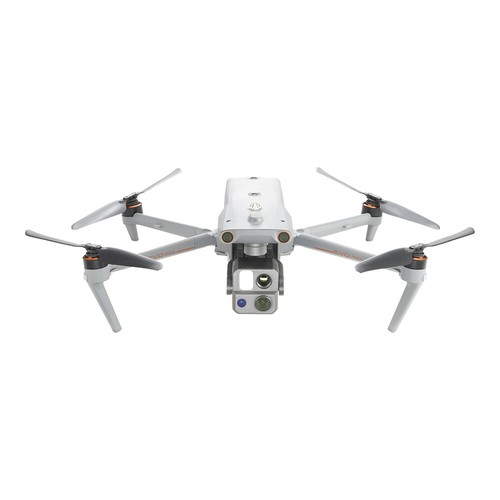

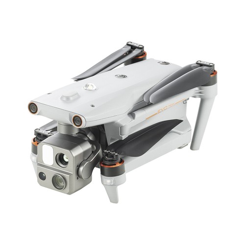
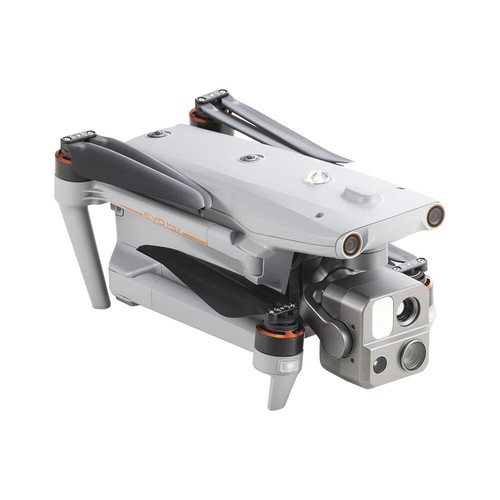
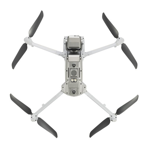


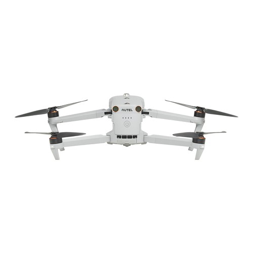


Reach New FrontiersThe Autel EVO Max 4T brings powerful technologies and advanced autonomy to professional drone users. The EVO Max 4T assesses complex environments to create real-time 3D flight paths for unparalleled obstacle avoidance. Advanced sensors make flight in GPS unavailable areas possible and the incredible new thermal payload unlocks new object identification and tracking scenarios. With a foldable weather-resistant design - the Autel EVO Max 4T is as portable as it is capable. |
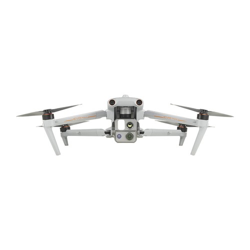
Hybrid Sensor PayloadThe EVO Max 4T payload integrates wide-angle, zoom and thermal camera with a laser rangefinder for all data capture needs and critical decision making. |
A Leader in Drone IntelligenceThe EVO Max 4T comes equipped with a wide array of features and capabilities that range from Autonomous Path Finding, Navigation in GPS Denied Environments, and Accurate Object Identification and Tracking.Autonomous Path Finding Autel's Autonomy Engine collects surrounding environmental data and plans 3D flight paths through complex environments such as mountains, forests, and buildings. Use cases include rapid 3D scene reconstruction, public safety overwatch, industrial inspection, and land surveying. Navigation In GPS Denied Environments Advanced sensors allow the EVO Max 4T to navigate within hardened structures, underground, or in environments without GPS. Accurate Object Identification And Tracking Based on Autel's AI recognition technology, the EVO Max 4T can automatically identify and lock onto different types of targets such as heat sources, moving people, or vehicles and achieve high-altitude tracking and data collection for law enforcement personnel.  |
No Blind Spots |
Anti Jam, Anti InterferenceThe Autel EVO Max 4T uses advanced flight control modules and algorithms specially designed to counter RFI, EMI, and GPS spoofing. This enables the EVO Max 4T to fly confidently near power lines, critical structures, and in complex areas. |
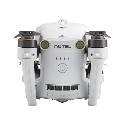
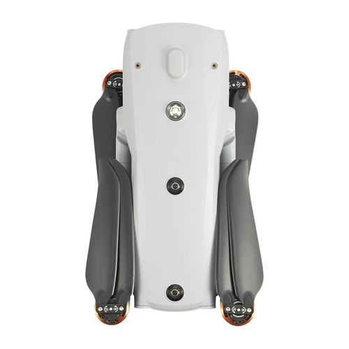
Platform CapabilityThe EVO Max 4T redefines portability with its powerful platform and all weather design. It comes equipped with the following features and capabilities: |
A-Mesh 1.0 - Mesh Networking TechnologyThe EVO Max 4T features the new A-Mesh system, enabling drone-to-drone autonomous communication, connection, and collaboration for seamless enterprise operations.Strong Anti-Interference The EVO Max 4T can communicate seamlessly with other drones in the vicinity, unlike a traditional chain structure. If a single drone fails or exits unexpectedly, the entire system will independently self-organize and continue to relay critical information. Beyond-Line-of-Sight Applications With A-Mesh, multiple aircrafts in the vicinity can act as relay points to greatly improve BVLOS operation effectiveness. Full-Fleet Control Multiple drones can be controlled autonomously by one pilot or by a group of pilots simultaneously with or without LTE coverage. Enhanced Range Communication nodes can be placed statically on hills or poles to provide full coverage to an area, or a swarm of drones can provide mobile communication points to extend the coverage of the entire group. |
Autel SkyLink 3.0The Autel EVO Max 4T SkyLink 3.0 system comes equipped with 6 antennas, 4 frequency bands, AES-256 encryption*, and optional 4G integration* to provide users with the most advanced flight capabilities ever seen in the EVO series. |
Autel Enterprise App PlatformThe Autel Enterprise App is built from the ground up for enterprise applications and features a brand-new interface for simple, efficient operation. Additional features and semi-autonomous modes maximize the EVO Max 4T's mission readiness and capability. |
Smart FeaturesThe EVO Max 4T comes equipped with the following intelligent features that were tailored for commercial end users:3D Map Planning Plan, create, and execute 3D waypoint mission plans on a 3D map. Mission Reproduction* Fly a manual or semi-autonomous mission, or string multiple missions together. The EVO Max 4T will automatically record the camera angles and replicate the mission you just flew. Quick Mission* Temporary quick missions can be created while executing other missions, and multiple sub-missions can be stacked for enhanced flexibility.  |
Multiple Mission TypesThe Enterprise App provides various autonomous and semi autonomous mission planning for public safety, inspection, surveying and other commercial applications.Waypoint Missions Users can add waypoints for flexible, non-structured flight paths. Rectangular Mission Supports one-click automatic generation of a rectangular flight area. Automatic Mission (Generation And Data Capture*) Automatically produce routes by adding regional boundary points through dots or importing KML files.  Terrain Follow* Maintain relatively constant altitude from the ground for uneven or sloped terrain. Oblique Photography Automatically plan 5 groups of routes (1 ortho + 4 oblique) according to the flight area set by the user. Spiral Mission* Supports helical flight search in a designated area for SAR.  Polygon Mission Supports one-click automatic generation of polygon flight areas. Vertical Scan* Perform vertical surveys for building facades, open pit walls, and towers. Corridor Mission* Supports intuitive and effective corridor mission planning for roads, rivers, pipelines, power lines and other narrow, large-scale terrain. *This feature will be available in a future update.  |
Zoom Camera Supports for 8K 10x optical zoom, and 160x Max. Hybrid Zoom with clear details on targets up to 1.24 miles away. | Wide Camera Moonlight Agorithm 2.0 boosts postprocessing anp allows the pilot to capture crisp, detailed images in low-light environments. Video: support 4K 30fps, max ISO 64000. Photo: Moonlight mode reduces noise and enhances HDR. | ||
Thermal Camera Equipped with 640*512 hightresolution thermal imaging camera, 30fps, and 16x digital zoom. | Laser Rangefinder Tap a target to get the coordinates and altitude rapidly from up to 0.75 miles away. | ||
Data SecurityFeaturing AES 128/256 storage, radio link and network encryption for operational security.Privacy Protection Data involving user and aircraft information, including flight logs, locations, and account information can only be physically accessed via the aircraft locally. Encrypted Data Storage Supports AES-256 encryption for photos, videos, and flight logs, are password-protected.  | |||
Multi-channel Projection Screen* Supports simultaneous output of RGB, infrared, night vision, and wide-angle images. AR Scene* Geo-location data and other aircraft location info detected by ADS-B can overlay on real-time map, which is convenient for users to confirm the drone's location and avoid airborne risks. *This feature will be available in a future update.  | |||
Autel SDKThe Autel SDK is open to the world, helping developers and partners reduce software and hardware development costs and jointly create a new industry ecosystem.Mobile SDK Open UX SDK (iOS & Android) can directly call up the ready-made interactive interface. Payload SDK* Unified interface standards support access to third-party mounts such as microphones and gas detectors. Cloud SDK* Enables remote live broadcast and control of drones and Nests through third-party platforms or web pages.  | |||
ApplicationThe Autel EVO Max 4T was designed for survey and inspections, search and rescue operations, public safety, and many other commercial applications. | |||
 | |||
IN THE BOX: 1 x Aircraft 1 x Battery 1 x Gimbal Cover 1 x 64GB MicroSD Card 1 x Battery Charger & Power Cable 3 x Clockwise Propellers 3 x Counter-Clockwise Propellers 1 x Screwdriver 1 x Smart Controller V3 1 x Smart Controller Lanyard 1 x Smart Controller Cover 1 x Pair of Joysticks 1 x RC Charger 1 x RC Charging Cable 1 x Data Cable 1 x Manual 1 x Quick Start Guide 1 x Packing List 1 x Rugged Case
SPECIFICATIONS: AIRCRAFT Weight: 3.5 lbs (1600g with battery and gimbal included) Max. Takeoff Weight: 4.41 lbs (1999 g) Dimensions: 576x660x149 mm (folded, including propellers) 340x407x148 mm (folded, excluding propellers) 257x136x133 mm (unfolded, excluding propellers) Diagonal Wheelbase: 1.52 ft (464mm) Max Ascent Speed: 8m/s Max Descent Speed: 6m/s Max Horizontal Speed (windless near sea level): 23m/s Max Service Ceiling Above Sea Level: 23000ft (7000m) Max Flight Time (windless): 42 minutes Max Hovering Time (windless): 38 minutes Max Wind Resistance: 27mph* *Takeoff and landing can withstand wind speeds up to 27 mph (12 m/s). IP Rating: IP43 Max Tilt Angle: 35° Max Angular Velocity: Pitch: 300°/s; Yaw: 120°/s Operating Temperature: -4°F to 122°F (-20°C - 50°C) Operating Frequency: 2.4G/5.2G*/5.8G/900MHz* GNSS: GPS+Galileo+BeiDou+GLONASS Transmitter Power (EIRP): 2.4GHz:<33dBm(FCC), <20dBm(CE/SRRC/MIC) 5.8GHz:<33dBm(FCC), <30dBm(SRRC), <14dBm(CE) 5.15-5.25GHz: < 23dBm(FCC/SRRC/MIC) 5.25-5.35GHz:<30dBm(FCC), <23dBm(SRRC/MIC) Hovering Accuracy: Vertical: ±0.1 m (Vision System enabled); ±0.3 m (GPS enabled); ±0.15 m (RTK enabled); Horizontal: ±0.15 m (Vision System enabled); ±0.3 m (GPS enabled); ±0.1 m (RTK enabled); ZOOM CAMERA (TELEPHOTO) Sensor: 1/2" CMOS, Effective pixels: 48M Lens: Focal length: 11.8-43.3mm (35mm, equivalent: 64-234mm) Aperture: f/2.8-f/4.8 Exposure Compensation: ±3EV 0.3EV/step ISO Range: Normal Mode: Auto: ISO100 ~ ISO6400 Manual: Photo: ISO100 ~ ISO12800 Video: ISO100 ~ ISO6400 Shutter Speed: Photo: 8s ~ 1/8000s Video: 1s ~ 1/8000s Max Photo Size: 8000×6000 Max Video Resolution: 7680×4320 WIDE CAMERA Sensor: 1/1.28 CMOS, Effective pixels: 50M Lens: DFOV: 85° Focal length: 4.5 mm (equivalent: 23 mm) Aperture: f/1.9 AF motor: 8-wire SMA, PDAF focus Exposure Compensation: ±3EV 0.3EV/step ISO Range: Auto: Photo: ISO100~ISO6400 Video: ISO100~ISO64000 (Night scene mode: up to ISO64000) Manual: Photo: ISO100~ISO12800 Video: ISO100~ISO6400 Shutter Speed: Photo: 8s ~ 1/8000s Video: 1s ~ 1/8000s Max. Video Resolution: 3840×2160 Photo Size: 8192x6144, 4096x3072 THERMAL CAMERA Thermal Imager: Uncooled VOx Microbolometer Lens: DFOV: 64° Aperture: 13mm Focus: f/1.2 Infrared Temperature Measurement Accuracy: 26.6~37.4 °F or reading ±3% (using the larger value) @ambient temperature -4°F to 140°F Video Resolution: 640x512 Photo Size: 640x512 Pixel Pitch: 12 um Temperature Measurement Method: Center Measurement, Spot Measurement, Rectangular Measurement Temperature Measurement Range: -4°F to 302°F, 32°F to 1022°F (-20°C to 150°C, 0 to 550°C) Temperature Alert: High and low temperature alarm thresholds, reporting coordinates and temperature values LASER RANGEFINDER Measurement Accuracy: ±3.3ft (1m) Measuring Range: 3937ft (1200m) GIMBAL Mechanical Range: Pan: -135° to 45° Tilt: -45° to 45° Roll: -45° to 45° Controllable Range: -90° to 30° Stable system: 3-axis mechanical gimbal (pan, tilt, roll) Max Control Speed (pitch): 200°/s Angular Vibration Range: <0.005° IMAGE TRANSMISSION Operating Frequency: 2.4G/5.2G*/5.8G/900MHz* *5.2GHz is only applicable for FCC, CE, and UKCA regions. 900MHz is only applicable for FCC regions. Max Transmission Distance (unobstructed, free of interference): 12.4 miles/20km (FCC), 4.9 miles/8km (CE) Independent Networking: Autel Smart Controller V3 Transmitter Power (EIRP): 2.4GHz:<33dBm(FCC), <20dBm(CE/SRRC/MIC) 5.8GHz:<33dBm(FCC), <30dBm(SRRC), <14dBm(CE) 5.15-5.25GHz: < 23dBm(FCC/SRRC/MIC) 5.25-5.35GHz:<30dBm(FCC), <23dBm(SRRC/MIC) AUTONOMY Non-GPS Hovering and Manual Flight: Indoor: Horizontal error =1.18in (At least have texture at one direction) Outdoor: Daytime: Within 1640ft (500m) flight height, horizontal error < 0.01*height Night: Manual flight is controllable within 328ft (100m) flight height Non-GPS Return-to-Home: Within 1640ft (500m) flight height, horizontal error of Return-to-Home point < 11.81in Automatic Obstacle Rerouting: High Speed Obstacle Rerouting: Flight speed up to 45mph (20m/s) when Min. safety distance to obstacle is 4.9ft (1.5m) High Precision Obstacle Rerouting: Flight speed could reach 6.7mph (3m/s) when Min. safety distance to obstacle is 1.64ft (0.5m) Multi-target Recognition and Tracking: Target identification types: people, vehicles, boats Number of targets detected: 64 Comprehensive recognition accuracy: > 85% MILLIMETER-WAVE RADAR SYSTEM Frequency: 60Ghz~64Ghz* *Please fly safely and consult your local laws and regulations. Size: 1.5x0.55x0.08 in (38x14x2mm) (LxWxH) Weight: 0.07oz (2g) EIRP: 18dBm Sensing Range: Upward: 5.9~787.4in (0.15~20m) Downward: 3.9~4724.4in(0.1~120m) Forward and Backward (Standard/Comfortable): 0.82~98.43ft (0.25~30m) Forward and Backward (Standard/Comfortable): 0.82~98.43ft (0.25~30m) FOV: Horizontal: (6dB): ±60°, Vertical (6dB): ±30° Speed Measurement Range: ±134mph (60m/s) Speed Measurement Accuracy: ≤1% Max. Tracking Target Number: 32 VISUAL SENSING SYSTEM Obstacle Sensing Range: Forward/Upward/Downward/Backward/Sideward: 0.2~50m FOV: Forward/Backward/Sideward: 60°(H), 80°(V) Upward/Downward: 360°(H), 190°(V) AUTEL SMART CONTROLLER V3 Screen: 7.9 inch, 2000nits max. brightness, 2048*1536 resolution External Battery: Capacity: 5800mAh Voltage: 11.55V Battery Type: Li-on Energy: 67Wh Charing time: 120mins Intelligent Lithium Ion Battery Operating Time: 3 hours (Max. brightness) 4.5 hours (50% brightness) Max Transmission Distance (with interference): 12.4 miles/20km (FCC), 4.9 miles/8km (CE) IP Rating: IP43 Storage: 128G GNSS: GPS+GLONASS+Galileo+Beidou+NavIC+QZSS Operating Temperature: -4°F to 104°F (-20°C to 40°C) Wi-Fi Protocol: WiFi Direct, Wi-Fi Display, 802.11a/b/g/n/ac Support 2 x 2 MIMO Wi-Fi Operating Frequency: 2.400 - 2.4835 GHz; 5.150 - 5.250GHz; 5.725 ? 5.850 GHz Transmitter Power (EIRP): 2.400 - 2.4835 GHz FCC/CE:=20dBm 5.150 - 5.250GHz FCC:=17dBm 5.725 ? 5.850 GHz FCC:=17dBm CE:=14dBm AIRCRAFT BATTERY Capacity: 8070mAh Voltage: 14.88V Battery Type: LiPo 4S Energy: 120wh Net Weight: 1.15 lbs (520g) Charging Temperature: 41°F to 113°F (5°C to 45°C) When the temperature is lower than 10°C (50° F), the self-heating function will be automatically enabled. Charging in a low temperature may shorten the lifetime of the battery. Hot Swap: Supported | |||


|

We accept Credit cards、Debit card、Apple Pay、Google Pay、PayPal、bank ect. payment.
All major credit cards are accepted through secure payment processor PayPal.
Payment must be received within 3 days of auction closing.
When buying multiple items, please use the eBay shopping cart and check out once for all the items instead of paying for them individually.When you click the Pay Now button, eBay will automatically determine if there are other items you have won or purchased from me and will combine them for your review.
Please Not:
Import duties,taxes and charges are not included in the item price or shipping charges.These charges are the buyer's responsibility.(Some regions in the United States can be exempted from tax, just communicate with us in advance)
Please check with your country's customs office to determine what these additional costs will be prior to bidding /buying.
These charges are normally collected by the delivering freight (shipping) company or when you pick the item up – do not confuse them for additional shipping charges.
We are not responsible for custom duties and related taxes. Orders will be shipped as a gift or as a sample. In general, no custom duties and tax will be charged.
The default shipping method is via UPS or USPS, Generally, the goods can be received within 2-4 business days, and the remote areas may receive the goods within 3-6 business days. Please kindly be patiently wait for your order.If you need to choose another logistics channel, please contact us before making payment.
We will ship according to your EBAY address but sorry that we can not accept P.O.BOX address.
Please make sure it’s correct and include phone number via PayPal when you make payment. This will help your product to be received safely and quickly! And we are not responsible for order's delay or miss because of your incomplete contact information.If you need to change your address, Please change it in PayPal first before you pay.
Items are usually shipped within 1-2 business days after payment confirmation. All items are shipped via mechanical & manual inspection + standard registered airmail.
Warranty is one year for the Americas region + APEC/South Africa/Venezuela and two years for the Europe region.
Items should be returned on buyers’ cost for repair or replacement.
Please contact us firstly when you need warranty service.
In case an item arrives faulty, please contact us in 30 days and keep it unused.
We will instruct you on how to return and get refund or replacement.
If after 30 days, or the item has been used, we have the right to decline your claim.
About us
Autel Robotics was founded in 2014 with the mission of developing unmanned aerial technologies to enable users across recreational and commercial platforms to meet or exceed their needs and expectations. We are a solutions-based team of multi-disciplined engineers, who are inspired by our customers and their desire to be more and to do more. It is that blend of science and passion that leads us to produce the best products in the industry.


Global
The company is headquartered in Shenzhen, the industrial and software frontier of China and the capital of drones. Autel also has extensive subsidiaries bases in the US, Germany, Italy and Singapore, recruiting top talent to research and develop leading drone technologies and autonomous solutions.
Among them, the R&D base at Nanshan i Park covers an area of 19,000 square feet, and the production base of Guangming Industrial manufacturing facility covers an area of 37,000 square feet.
Autel Robotics has deployed 2215 patent applications worldwide, and 879 patents have been authorized globally. Autel Robotics' committment to R&D has earned it a leading position in the global drone industry.


We are committed to your satisfaction after your purchase.
If you are not satisfied with your purchase in any way please give us an opportunity to try and make it right before leaving feedback.We will answer your questions within 1 working days.
Customer Service Hours: M-F: 9:30AM - 18:00PM BST (Beijing Standard Time)
For urgent or bulk orders, please contact us.

