1852 Meyer Map of the Black Sea and Adjacent Countries 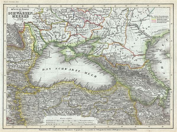 WE SELL ONLY ORIGINAL ANTIQUE MAPS - NOT REPRODUCTIONS Title: Kustenlander des Schwarzen Meeres. Description: This is a scarce 1852 map of the Black Sea and adjacent regions by Joseph Meyer. Centered on the Black Sea, the map focuses on the area immediately surrounding it. Includes parts of what is modern day Ukraine, Moldova, Romania, Bulgaria, Turkey, Georgia, Azerbaijan, Armenia, Iran and Russia. The map is color coded to show Russian, Austrian, Turkish and Persian territories. The map notes numerous cities, rivers, mountain ranges and other topographical features. This map was engraved by Lieutenant L. Renner and issued in Meyer's Zeitung Atlas. Although all the maps in this atlas are not individually dated, the title page and maps were often updated while the imprint with the date was not, causing confusion to the exact date for some of the maps. Moreover some maps in the atlas were taped in at a later date as an update to the atlas. We have dated the maps in this collection to the best of our ability. Size: Printed area measures 8 inches high by 10.5 inches wide. Condition: Very good. Minor overall toning and some spotting. Shipping: Shipping rates are not negotiable. Items are shipped within three business days of receiving payment. We are happy to consolidate shipping where possible. The following shipping options are available: 1. FedEx Overnight (45 USD). USA Only. Signature Required. Customs: International buyers are responsible for paying duty and taxes on delivery. DHL or FedEx will contact the buyer by telephone to arrange tax payment if it is levied. Duty varies by country and we cannot predict the amount you will be charged. Some countries are duty free, others are not. Typically, a customs duty and/or VAT tax will be assessed on all parcels to continental Europe. Sometimes duty or tax is due in China, but is seems very random. Hong Kong, Singapore, Korea, and Taiwan have never assessed duty on a map we shipped. Maps shipped to the UK should be duty free as educational materials, but from time to time duty of 5% is assessed incorrectly by the UK customs agents. Insurance: All shipments are insured privately against loss and damage. All of our shipments require a signature for insurance purposes. If you have any questions please feel free to email us through eBay. Other Services Conservation Framing: Geographicus recommends basic conservation framing services for any antique paper. We do not offer this service. |
