1912 Century Map of Wyoming County, New York 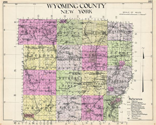 WE SELL ONLY ORIGINAL ANTIQUE MAPS - NOT REPRODUCTIONS Title: Wyoming County New York. Description: A highly appealing 1912 large format folio map of Wyoming County, New York, issued for the New Century Atlas of Counties of the State of New York. The map covers from Bennington to Arcade and from Covington to Genesee Falls. The map includes Attica, Middlebury, Sheldon, Orangeville, Warsaw, Perry, Castile, Gainesville, Wethers Field, Java, Eagle and Pike. There is appealing detail throughout with the roads, towns, and railroad lines clearly represented. Various communities are identified with larger districts highlighted in vivid pastels. This map was issued as plate nos. 256 and 257 in Everts' New Century Atlas of Counties of the State of New York. Size: Printed area measures 23.5 inches high by 29 inches wide. Condition: Very good. Original centerfold. Blank on verso. Shipping: Shipping rates are not negotiable. Items are shipped within three business days of receiving payment. We are happy to consolidate shipping where possible. The following shipping options are available: 1. FedEx Overnight (45 USD). USA Only. Signature Required. Customs: International buyers are responsible for paying duty and taxes on delivery. DHL or FedEx will contact the buyer by telephone to arrange tax payment if it is levied. Duty varies by country and we cannot predict the amount you will be charged. Some countries are duty free, others are not. Typically, a customs duty and/or VAT tax will be assessed on all parcels to continental Europe. Sometimes duty or tax is due in China, but is seems very random. Hong Kong, Singapore, Korea, and Taiwan have never assessed duty on a map we shipped. Maps shipped to the UK should be duty free as educational materials, but from time to time duty of 5% is assessed incorrectly by the UK customs agents. Insurance: All shipments are insured privately against loss and damage. All of our shipments require a signature for insurance purposes. If you have any questions please feel free to email us through eBay. Other Services Conservation Framing: Geographicus recommends basic conservation framing services for any antique paper. We do not offer this service. |
