1851 Tallis and Rapkin Map of Western Australia 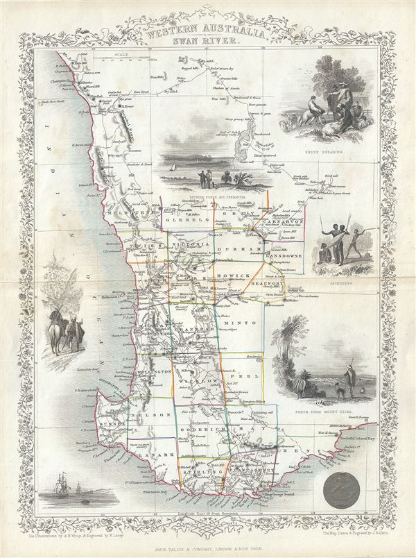 WE SELL ONLY ORIGINAL ANTIQUE MAPS - NOT REPRODUCTIONS Title: Western Australia, Swan River. Description: This is a scarce 1851 example of John Tallis and John Rapkin's 1851 map of Western Australia. It covers southwestern Western Australia from Champion Bay south around Sussex to Doubtful Island Bay. This map records the early settlements of the United Kingdom in the western part of Australia. It notes numerous counties, roadways, rivers, geographical features, and more. Swan River is identified. The Swan River Colony including Perth was settled by the British in 1829. York, noted here, was the first inland settlement by the British in 1831. Albany with King George Sound, along with its surrounding areas is called Plantagenet, supposedly named so because King George, the reigning British monarch at the time, believed that he was related to the Plantagenet lineage of kings, who ruled many centuries earlier. This map includes illustrations by A. H. Wray of Sheep Shearing, Aborigines, Perth from Mount Eliza and a view Between Perth and Fremantle. Illustrations of ships and natives is also included. The whole has the highly decorative presentation and elaborate border distinctive of Tallis maps. This map was issued as part of the 1851 edition of John Tallis and Company's The Illustrated Atlas, And Modern History of the World. Size: Printed area measures 14 inches high by 10.5 inches wide. Condition: Very good. Minor wear along original centerfold. Minor spotting. Blank on verso. Shipping: Shipping rates are not negotiable. Items are shipped within three business days of receiving payment. We are happy to consolidate shipping where possible. The following shipping options are available: 1. FedEx Overnight (45 USD). USA Only. Signature Required. Customs: International buyers are responsible for paying duty and taxes on delivery. DHL or FedEx will contact the buyer by telephone to arrange tax payment if it is levied. Duty varies by country and we cannot predict the amount you will be charged. Some countries are duty free, others are not. Typically, a customs duty and/or VAT tax will be assessed on all parcels to continental Europe. Sometimes duty or tax is due in China, but is seems very random. Hong Kong, Singapore, Korea, and Taiwan have never assessed duty on a map we shipped. Maps shipped to the UK should be duty free as educational materials, but from time to time duty of 5% is assessed incorrectly by the UK customs agents. Insurance: All shipments are insured privately against loss and damage. All of our shipments require a signature for insurance purposes. If you have any questions please feel free to email us through eBay. Other Services Conservation Framing: Geographicus recommends basic conservation framing services for any antique paper. We do not offer this service. |
