1590 Adrichem Map of the Tribe of Simeon, Israel (South of Canaan) 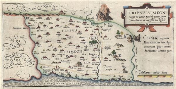 WE SELL ONLY ORIGINAL ANTIQUE MAPS - NOT REPRODUCTIONS Title: Tribus Simeon nempe ea Terrae Sanctae portio, quam tribus Simeon in ingressu nacta fuit. Description: This is a fine example of Christian van Adrichem's rare 1590 map of the lands granted to the Tribe of Simeon at the time of Joshua's division of the Twelve Tribes. Oriented to the East and identifies the lands of the Philistines as well as timber lands rich in Cedar. The Tribe of Simeon occupied the region southwest of Canaan and was bounded by the lands granted to the Tribes of Dan and Judah. Numerous Biblical sites are noted throughout. This map is the tenth of ten maps of the Holy Land prepared by Christian van Adrichem for publication in his Theatrum Terrae Sanctae. Adrichem's maps for the Theatrum were prepared between 1580 and 1585, but were published posthumously by his associate, Gerardis Brunius of Koln, in 1590. The publication went through several later editions and served as a basis for most subsequent maps of the Holy Land well into the 18th century. Size: Printed area measures 7.5 inches high by 14.5 inches wide. Condition: Very good. Minor wear along original fold lines. Original platemark visible. Weak impression near top border. Shipping: Shipping rates are not negotiable. Items are shipped within three business days of receiving payment. We are happy to consolidate shipping where possible. The following shipping options are available: 1. FedEx Overnight (45 USD). USA Only. Signature Required. Customs: International buyers are responsible for paying duty and taxes on delivery. DHL or FedEx will contact the buyer by telephone to arrange tax payment if it is levied. Duty varies by country and we cannot predict the amount you will be charged. Some countries are duty free, others are not. Typically, a customs duty and/or VAT tax will be assessed on all parcels to continental Europe. Sometimes duty or tax is due in China, but is seems very random. Hong Kong, Singapore, Korea, and Taiwan have never assessed duty on a map we shipped. Maps shipped to the UK should be duty free as educational materials, but from time to time duty of 5% is assessed incorrectly by the UK customs agents. Insurance: All shipments are insured privately against loss and damage. All of our shipments require a signature for insurance purposes. If you have any questions please feel free to email us through eBay. Other Services Conservation Framing: Geographicus recommends basic conservation framing services for any antique paper. We do not offer this service. |
