1784 Santini Map of the World on a Dual Polar Projection 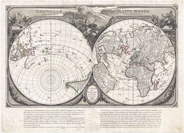 WE SELL ONLY ORIGINAL ANTIQUE MAPS - NOT REPRODUCTIONS Title: Nouvelle Mappe Monde dedièe au progrès de nos connoissances. Description: An impressive and unusual 1784 map of the world on dual polar projections by François Santini and the Remondini family. This map was originally drawn by Nicholas-Antoine Boulanger and published in Paris by Chez R. J. Julien in 1753. Boulanger divides the world into separate hemispheres, a Hemisphere Maritime and a Hemisphere Terrestre, asking the question, why is most of the world's land mass limited to only one half of the sphere? The map simultaneously lionizes France by emphasizing that this unique projection is possible only when the prime meridian runs through Paris. The finely engraved allegorical surround, notably striking even compared to other maps of the period, was drawn by Pierre Philippe Choffard (1730 - 1809) and succeeds in underscoring the map's underlying Franco-centric argument. Speculative Cartography This map is of particular interest for its treatment of the North Pacific. When Boulanger originally drew this map, the Northern Pacific region was largely unexplored and its geographical deportment a subject of hot debate in the scientific academies of London, Paris, and St. Petersburg. These debates yielded speculative geographies that included such cartographic myths as the Sea of the West, the lakes of Admiral De Fonte, Muller's Peninsula, apocryphal islands, and more. Published after Captain James Cook's final voyage, but before the widespread dissemination of the new information it produced, this map embraces many of those theories. In the Pacific northwest, the mythical Sea of the West (Mer de L'Ouest) and the apocryphal discoveries of Admiral de Fonte are illustrated, and just west of Kamchatka, where a large speculative island is identified. The Sea of the West A magnificent sea, called the Sea of the West, or in this case the Mer de L'Ouest, occupies the greater part of the northwestern part of the continent. This body of water was speculated by Philippe Buache and Jospeh-Nicolas De l'Isle in the early 18th century based upon wishful thinking, American Indian stories, and the somewhat questionable 16th century explorations of Juan de Fuca - themselves possibly an attempt by the known pilot de Fuca to lay claim to suppressed information associated with Drake's voyages. Here the cartographer gives the Mer de L'Ouest a transitional expression, not so grand as on the Buache / De L'Isle map, nor so bay-like as the Nolin variant. The cartographer specifically does not connect the Mer de L'Ouest to either the factual network of lakes and rivers extending westward form the Hudson Bay or to the speculative De Fonte network just to the north. Admiral De Fonte's Northwest Passage The tale of De Fonte's discoveries in the American Northwest is particularly interesting. The De Fonte legend first appeared in a 1706 English publication entitled Memoirs of the Curious. This short-lived magazine published a previously unknown account by a supposed Spanish Admiral named Bartholomew de Fonte. De Fonte is said to have sailed up the Pacific coast of North America in 1640. On this voyage he apparently discovered a series of gigantic lakes, seas, and rivers heading eastward from the Pacific towards Hudson Bay. On one of these inland lakes, he supposedly met with a westward bound ship from Boston that could only have come through the Northwest Passage. Today, based upon many inaccuracies and falsities, we know the entire De Fonte article to have been a fabrication, nonetheless, it set 18th century afire with speculation that a Northwest Passage must indeed both exist and be navigable. Benjamin Franklin and others wrote long defenses of De Fonte. Our map offers an uncommon variant on the De Fonte passage, positioning its western entrada well to the north in order to accommodate the Sea of the West and situating its outlet at the Baffin rather than the Hudson Bay. The representation of Australia Nouvelle Hollande is also of interest. At the time, the full extent of Australia was completely unknown. There was some speculation that it must connect with Tasmania, New Zealand, and New Guinea, but no solid cartographic evidence of this, or to the contrary, was forthcoming until the expeditions of James Cook. This map was originally published in Paris by R. J. Julien in 1753 and, at the same time, in Nuremburg by Homan Heirs. It was subsequently issued again, with minimal changes, by Chez Lattre in 1760. The plates were acquired by François Santini, who published an edition in Venice in 1778. The present example is the last edition, 1784, Remondini Venice edition. Size: Printed area measures 20 inches high by 28 inches wide. Condition: Very good. Original Pressmark. Slight centerfold wear. Shipping: Shipping rates are not negotiable. Items are shipped within three business days of receiving payment. We are happy to consolidate shipping where possible. The following shipping options are available: 1. FedEx Overnight (45 USD). USA Only. Signature Required. Customs: International buyers are responsible for paying duty and taxes on delivery. DHL or FedEx will contact the buyer by telephone to arrange tax payment if it is levied. Duty varies by country and we cannot predict the amount you will be charged. Some countries are duty free, others are not. Typically, a customs duty and/or VAT tax will be assessed on all parcels to continental Europe. Sometimes duty or tax is due in China, but is seems very random. Hong Kong, Singapore, Korea, and Taiwan have never assessed duty on a map we shipped. Maps shipped to the UK should be duty free as educational materials, but from time to time duty of 5% is assessed incorrectly by the UK customs agents. Insurance: All shipments are insured privately against loss and damage. All of our shipments require a signature for insurance purposes. If you have any questions please feel free to email us through eBay. Other Services Conservation Framing: Geographicus recommends basic conservation framing services for any antique paper. We do not offer this service. |
