1881 U.S.C.G.S. Nautical Chart of the New England Coast: Boston, Cape Ann, Maine 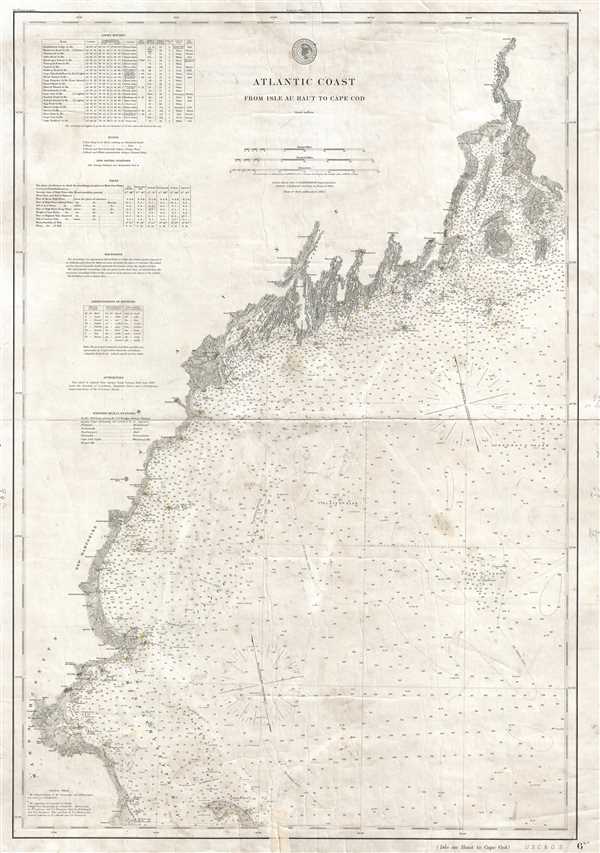 WE SELL ONLY ORIGINAL ANTIQUE MAPS - NOT REPRODUCTIONS Title: Atlantic Coast from Isle au Haut to Cape Cod. Description: This is an 1881 U.S. Coast and Geodetic Survey nautical chart or maritime map of the northern Atlantic coastline of the United States. The map depicts the Atlantic coastline from the Isle au Haut and Penobscot Bay, Maine to Cape Cod and Kingston, Massachusetts and from the coastline into the Atlantic Ocean as far as Cashe's Ledge and Jeffrey's Bank. A highly detailed depiction of the coastline, all of the river mouths islands, and islets are illustrated in detail. Innumerable depth soundings are included all along the coast. Lighthouses have all been shaded yellow. Cities and towns along the coast are labeled, including Bangor, Kennebunkport, and Portland, Maine; Portsmouth, New Hampshire; and Newburyport, Salem, and Boston, Massachusetts. A table of light houses, with latitude and longitude, character of the light, the time between flashes, the distance at which the light is visible (in nautical miles) and other information included is situated on the upper left. Information about buoys, 'life saving stations', tides, and soundings, and other information important to the mariner is included below the table containing the information about light houses. This map was published as plate no. 1777 by the U.S. Coast and Geodetic Survey in March 1881, Carlile Pollock Patterson, Superintendent. Size: Printed area measures 32 inches high by 22 inches wide. Condition: Good. Verso repair of centerfold separation. Closed tears professionally repaired on verso. Blank on verso. Shipping: Shipping rates are not negotiable. Items are shipped within three business days of receiving payment. We are happy to consolidate shipping where possible. The following shipping options are available: 1. FedEx Overnight (45 USD). USA Only. Signature Required. Customs: International buyers are responsible for paying duty and taxes on delivery. DHL or FedEx will contact the buyer by telephone to arrange tax payment if it is levied. Duty varies by country and we cannot predict the amount you will be charged. Some countries are duty free, others are not. Typically, a customs duty and/or VAT tax will be assessed on all parcels to continental Europe. Sometimes duty or tax is due in China, but is seems very random. Hong Kong, Singapore, Korea, and Taiwan have never assessed duty on a map we shipped. Maps shipped to the UK should be duty free as educational materials, but from time to time duty of 5% is assessed incorrectly by the UK customs agents. Insurance: All shipments are insured privately against loss and damage. All of our shipments require a signature for insurance purposes. If you have any questions please feel free to email us through eBay. Other Services Conservation Framing: Geographicus recommends basic conservation framing services for any antique paper. We do not offer this service. |
