1926 Montross-Clarke Railroad Map of the Western United States 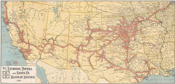 WE SELL ONLY ORIGINAL ANTIQUE MAPS - NOT REPRODUCTIONS Title: The Atchison, Topeka, and Santa Fe Railway System. Description: This is a 1926 Montross and Clarke map of the Atchison, Topeka and Santa Fe (ATSF) railway network in the Western United States. The map depicts the region from the Pacific Ocean to Chicago and from Oregon, Idaho, Wyoming, Nebraska, Iowa, and Illinois to Texas, Mexico, and the Gulf of Mexico. Incredibly detailed, the ATSF's route is illustrated in red, with each stop along its each route marked and labeled. Other rail lines throughout the American West are illustrated and labeled, such as the Union Pacific, Southern Pacific, and the Western Pacific. Important cities and towns along these routes are also labeled. The Grand Canyon, which had only been made a National Park in 1919, is depicted in Arizona, with a ATSF spur line servicing the park. The Atchison, Topeka and Santa Fe The ATSF was chartered on February 11, 1859, with the stated goal of joining Atchison and Topeka, Kansas with Santa Fe, New Mexico. The ATSF reached Albuquerque in 1880, after a serious controversy with the Denver and Rio Grande Western Railroad known as the 'Royal Gorge Railroad War' that had to be settled by federal authorities and creating real estate offices to sell off the land granted to them across Kansas for settlers to make the route economically viable. Santa Fe, the original destination, was eventually reached by a spur branch of the railway from Lamy, New Mexico. Eventually, when the ATSF connected with the Southern Pacific at Deming, New Mexico, it completed the second transcontinental railroad route. In 1897, when the ATSF traded a railroad line in Mexico with the Southern Pacific for its line from Needles to Barstow, the ATSF became the first railroad in the United States to own its own line from Chicago to the Pacific coast. The ATSF merged with the Burlington Northern Railroad in 1995, creating the Burlington Northern and Santa Fe Raolroad (BNSF) which still operates today. This map was produced by the Montross and Clarke Company in 1926. Size: Printed area measures 17.5 inches high by 36.5 inches wide. Condition: Very good. Wear along original fold lines. Light soiling along top border. Blank on verso. Shipping: Shipping rates are not negotiable. Items are shipped within three business days of receiving payment. We are happy to consolidate shipping where possible. The following shipping options are available: 1. FedEx Overnight (45 USD). USA Only. Signature Required. Customs: International buyers are responsible for paying duty and taxes on delivery. DHL or FedEx will contact the buyer by telephone to arrange tax payment if it is levied. Duty varies by country and we cannot predict the amount you will be charged. Some countries are duty free, others are not. Typically, a customs duty and/or VAT tax will be assessed on all parcels to continental Europe. Sometimes duty or tax is due in China, but is seems very random. Hong Kong, Singapore, Korea, and Taiwan have never assessed duty on a map we shipped. Maps shipped to the UK should be duty free as educational materials, but from time to time duty of 5% is assessed incorrectly by the UK customs agents. Insurance: All shipments are insured privately against loss and damage. All of our shipments require a signature for insurance purposes. If you have any questions please feel free to email us through eBay. Other Services Conservation Framing: Geographicus recommends basic conservation framing services for any antique paper. We do not offer this service. |
