1872 Yves and Barret Pictorial Map of Europe after the Franco-Prussian War 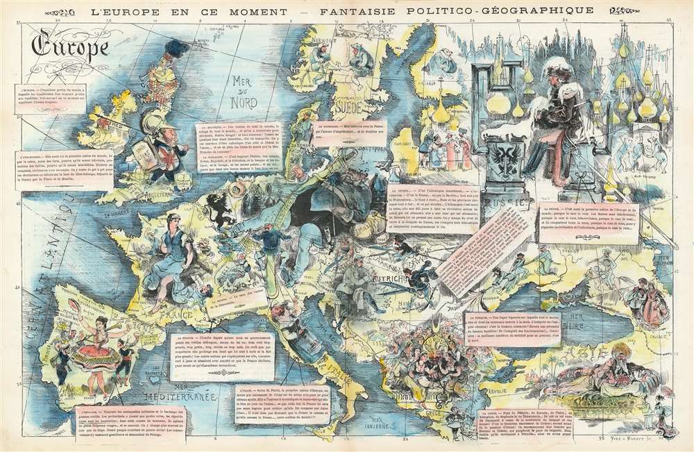 WE SELL ONLY ORIGINAL ANTIQUE MAPS - NOT REPRODUCTIONS Title: L'Europe en Ce Moment - Fantaise Politico-Géographique. Description: This is an 1872 Yves and Barret pictorial map of Europe featuring caricatured sketches of each of the nations of Europe. Depicting the continent from the Atlantic Ocean to the Caspian Sea and from Scandinavia and the Shetland Islands to the Mediterranean Sea, personifications of each nation illustrate the map, creating connotations in the viewer's mind before they even read the accompanying text boxes. Newly united Germany of course dominates central Europe in the form of the Kaiser, who is illustrated sprawled out across what the French must have considered to be an ominously large amount of continental Europe. He is shown reclining against a cannon and artillery shells and accompanied by a gigantic sword and holding an empty beer stein and smoking a large pipe. A much smaller German soldier is illustrated holding the puppet strings of many other European countries, including Italy, Spain, and Austria. France, which had just lost the Franco-Prussian War to the newly-United Germany, is depicted in the form of Marianne, the French national symbol, who is being tended by several smaller officials and military men. The men are trying to get her to hold back her anger at having German guns pointed at her from Strasbourg (Alsace and Lorraine were annexed by Germany after the Franco-Prussian War) and to form a new government following the chaos of the defeat and the unrest and chaos of the Paris Commune. England is shown as a man in armor decorated with the Union Jack and a book for a shield. He is surrounded by the Bible and bales of cotton. Spain, Italy, and Austria are depicted as contentedly going about their business, per the German soldier's wishes, but the Austrian are illustrated holding scissors, possibly in an attempt to cut ties with the now overly powerful Germany. Russia is a froze wasteland with their onion-domed churches and a land where everything happens 'because the czar wants it to be'. The Turks are depicted lavishly, as a single man surrounded by elegantly dressed women attending to his every whim. Publication History and CensusThis map was engraved by Yves and Barret and published in the July 6, 1872 publication of La Vie Parisienne. We are aware of two examples in institutional collections, which are part of the David Rumsey Map Collection at Stanford University and Persuasive Maps: the PJ Mode Collection at Cornell University. This map is incredibly rare on the private market and we are aware of no other colored examples.Size: Printed area measures 13 inches high by 20.5 inches wide. Condition: Very good. Even overall toning. Light wear along original centerfold. Text on verso. Shipping: Shipping rates are not negotiable. Items are shipped within three business days of receiving payment. We are happy to consolidate shipping where possible. The following shipping options are available: 1. FedEx Overnight (45 USD). USA Only. Signature Required. Customs: International buyers are responsible for paying duty and taxes on delivery. DHL or FedEx will contact the buyer by telephone to arrange tax payment if it is levied. Duty varies by country and we cannot predict the amount you will be charged. Some countries are duty free, others are not. Typically, a customs duty and/or VAT tax will be assessed on all parcels to continental Europe. Sometimes duty or tax is due in China, but is seems very random. Hong Kong, Singapore, Korea, and Taiwan have never assessed duty on a map we shipped. Maps shipped to the UK should be duty free as educational materials, but from time to time duty of 5% is assessed incorrectly by the UK customs agents. Insurance: All shipments are insured privately against loss and damage. All of our shipments require a signature for insurance purposes. If you have any questions please feel free to email us through eBay. Other Services Conservation Framing: Geographicus recommends basic conservation framing services for any antique paper. We do not offer this service. |
