1920 Map of Adirondack Region Telephone Companies with Manuscript Notations 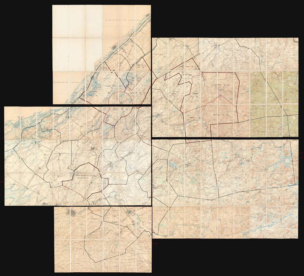 WE SELL ONLY ORIGINAL ANTIQUE MAPS - NOT REPRODUCTIONS Title: [Adirondack Regional Telephone Companies]. Description: An interesting telecommunications infrastructure piece, this is a c. 1920 map of Adirondack region telephone companies featuring manuscript annotations throughout. Dissected and mounted on linen on five sheets of varying sizes, the map depicts the region from Howe Island and Wolfe Island in the Saint Lawrence River to Lake Lila and from Prescott, Ontario to Lorraine, New York. Although the exact purpose of the maps remains unclear, it seems obvious that they were used for line maintenance and management. Adirondacks Telephone CompaniesEight rural telephone companies are identified: Citizens Telephone Company, Rossie Telephone Company, Pope Mills Telephone Company, Macomb Telephone Company, Maple Ridge Telephone Company, Hermon Telephone Company, Edwards Telephone Company, and New York Telephone Company (formerly the North Country Telephone and Telegraph Company). The territory covered by each of these companies is outlined in red and each company is identified in black block lettering, sometimes in several places within their service area. Most of these service areas are also bordered by black lines, perhaps suggesting that the other areas are service areas for other telephone companies that remain unlabeled.Manuscript Telephone LinesManuscript telephone lines stretch across all five sheets, with each line labeled numerous times and marked by differently colored dashed lines to make them easier to trace. Line 63, for example, is marked by a dashed green line and stretches form Clayton, New York and runs along the Saint Lawrence River to Alexandria Bay. Line 57, also marked by a green dashed line, runs from Carthage on the Black River in the lowermost sheet through two other sheets before ending at Benson Mines near Star Lake. Numerous other lines wind their way through the region except, as is noted in pencil, just below the town of Lafargeville east to Theresa. These pencil notations appear to be suggesting that a line connecting Line 61, Line 9, and Line 53 should be constructed below Lafargeville east to Theresa.A Closer Look at the Printed MapCountless towns and villages are labeled throughout the region, including Watertown, Carthage, Gouverneur, Ogdensburg, and Canton. Rivers, lakes, and swamps are also labeled. Since U.S. Geodetic Survey topographic maps provide the base upon which all the notations concerning the telephone companies were done, topographic lines are illustrated throughout, allowing the viewer an understanding of the land itself.Publication HistoryAs stated above, this map was compiled from several different maps published by the U.S. Geodetic Survey in the early 20th century, most likely in different years. We have been unable to pinpoint an exact date for the creation of the map, due to the lack of available information about the specific telephone companies referenced. We believe that it was compiled c. 1920 using U.S. Geodetic Survey maps that were most likely published in several different years.Size: Printed area measures 74 inches high by 82 inches wide. Condition: Five sheets of varying size laid down on linen. Light wear along original fold lines. All are blank on verso. Size above represents composite. Shipping: Shipping rates are not negotiable. Items are shipped within three business days of receiving payment. We are happy to consolidate shipping where possible. The following shipping options are available: 1. FedEx Overnight (45 USD). USA Only. Signature Required. Customs: International buyers are responsible for paying duty and taxes on delivery. DHL or FedEx will contact the buyer by telephone to arrange tax payment if it is levied. Duty varies by country and we cannot predict the amount you will be charged. Some countries are duty free, others are not. Typically, a customs duty and/or VAT tax will be assessed on all parcels to continental Europe. Sometimes duty or tax is due in China, but is seems very random. Hong Kong, Singapore, Korea, and Taiwan have never assessed duty on a map we shipped. Maps shipped to the UK should be duty free as educational materials, but from time to time duty of 5% is assessed incorrectly by the UK customs agents. Insurance: All shipments are insured privately against loss and damage. All of our shipments require a signature for insurance purposes. If you have any questions please feel free to email us through eBay. Other Services Conservation Framing: Geographicus recommends basic conservation framing services for any antique paper. We do not offer this service. |
