1794 Laurie amd Whittle Nautical Map of the Northwest Java (Jakarta), Indonesia 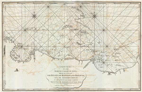 WE SELL ONLY ORIGINAL ANTIQUE MAPS - NOT REPRODUCTIONS Title: A New Chart of the North Coast of Java, wherein are described The Roads of Bantam and Batavia, from the Manuscript Draught of the Dutch East India Company. Description: This is a fine example of Laurie and Whittle's 1794 nautical chart or maritime map of northwestern Java. The map covers from Bantam Bay (Selat Sunda) and Hill (Serang, Indonesia) eastwards as far as Batavia (Jakarta, Indonesia). This region was a major battleground between rival Dutch, British, and Portugese trading monopolies. The Dutch and British in particular contested over northwestern Java, with its easy access to regional spice, in particular pepper, ports. In 1602 the British East India Company established a trade entrepot at Bantam to contest Dutch East India Company (VOC) control based in nearby Batavia. The Dutch, allied with a local Sultan, eventually drove the English out Bantam and Java itself. By the end of the 18th century, when this map was made, the Bantam entrepot was little more than a name on a map - as seen here - while Batavia further east had risen, with a population of nearly one million, to dominate Java. In 1800, just six years after this map was published, the VOC was formally dissolved and the Dutch East Indies established in its place as a full-fledged national colonial venture. The British meanwhile established themselves in Bencoolen, on Sumatra, and later in Singapore and Malacca. Laurie and Whittle prepared this chart for their 1799 issue of the East-India Pilot. Though most charts in the East-India Pilot were derived from earlier maps prepared for Jean-Baptiste d'Apres de Mannevillette's 1745 Neptune Oriental, this particular chart is a new production unique to Laurie and Whittle. The map offers rich detail including countless depth soundings, notes on the sea floor, commentary on reefs, rhumb lines, shoals, place names and a wealth of other practical information for the mariner. This chart is cartographically derived from earlier manuscript maps prepared by the Dutch East India Company (VOC) and later corrected and improved from an English draft prepared by Captain Henry Smedley. This map was registered by Laurie and Whittle from their offices at 53 Fleet Street, London, on May 12, 1794. Size: Printed area measures 23 inches high by 35 inches wide. Condition: Very good. Minor wear and verso repair along original centerfold. Original platemark visible. Some offsetting. Shipping: Shipping rates are not negotiable. Items are shipped within three business days of receiving payment. We are happy to consolidate shipping where possible. The following shipping options are available: 1. FedEx Overnight (45 USD). USA Only. Signature Required. Customs: International buyers are responsible for paying duty and taxes on delivery. DHL or FedEx will contact the buyer by telephone to arrange tax payment if it is levied. Duty varies by country and we cannot predict the amount you will be charged. Some countries are duty free, others are not. Typically, a customs duty and/or VAT tax will be assessed on all parcels to continental Europe. Sometimes duty or tax is due in China, but is seems very random. Hong Kong, Singapore, Korea, and Taiwan have never assessed duty on a map we shipped. Maps shipped to the UK should be duty free as educational materials, but from time to time duty of 5% is assessed incorrectly by the UK customs agents. Insurance: All shipments are insured privately against loss and damage. All of our shipments require a signature for insurance purposes. If you have any questions please feel free to email us through eBay. Other Services Conservation Framing: Geographicus recommends basic conservation framing services for any antique paper. We do not offer this service. |
