1754 Gabriel Ramirez Map of the Mediterranean Coast 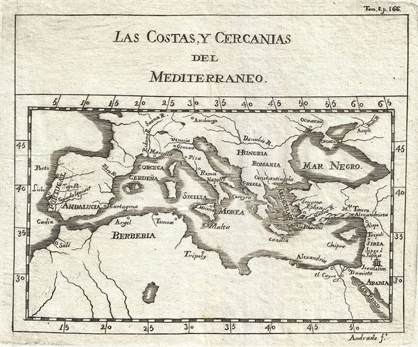 WE SELL ONLY ORIGINAL ANTIQUE MAPS - NOT REPRODUCTIONS Title: Las Costas, Y Cercanias del Mediterraneo. Description: This is an uncommon 1754 map of the Mediterranean Coast by Gabriel Ramirez. Centered on the Mediterranean Sea, it covers from Portugal east as far as Arabia, including the Barbary Coast and the Black Sea. Major rivers and cities are identified including Jerusalem, Constantinople, Rome, Naples, and others. When this map was made, this region, particularly western Mediterranean, was a hotbed of piracy. The Barbary Pirates would attack trading ships passing through the narrow Gibraltar straits and western Mediterranean. Ships would be destroyed or appropriated, cargo sized, and the crews and passengers enslaved. By the early 19th century, piracy in this region had become so intense that the United States launched its first major naval offensive against Tripoli. This map was originally prepared in French by Abbot M. Pluche and translated into Castilian Spanish. Engraved by Jose Andrade for publication in Volume VII, Part 4 of D. Gabriel Ramirez's Espectaculo de la Naturaleza, O Conversaciones a Cerca de Las Particularidades de la Historia Natural. Size: Printed area measures 6 inches high by 7 inches wide. Condition: Very good. Minor wear along original fold lines. Original platemarks visible. Blank on verso. Shipping: Shipping rates are not negotiable. Items are shipped within three business days of receiving payment. We are happy to consolidate shipping where possible. The following shipping options are available: 1. FedEx Overnight (45 USD). USA Only. Signature Required. Customs: International buyers are responsible for paying duty and taxes on delivery. DHL or FedEx will contact the buyer by telephone to arrange tax payment if it is levied. Duty varies by country and we cannot predict the amount you will be charged. Some countries are duty free, others are not. Typically, a customs duty and/or VAT tax will be assessed on all parcels to continental Europe. Sometimes duty or tax is due in China, but is seems very random. Hong Kong, Singapore, Korea, and Taiwan have never assessed duty on a map we shipped. Maps shipped to the UK should be duty free as educational materials, but from time to time duty of 5% is assessed incorrectly by the UK customs agents. Insurance: All shipments are insured privately against loss and damage. All of our shipments require a signature for insurance purposes. If you have any questions please feel free to email us through eBay. Other Services Conservation Framing: Geographicus recommends basic conservation framing services for any antique paper. We do not offer this service. |
