1754 Vaugondy Map of Counties of Hainaut and Cambrai, Belgium and France 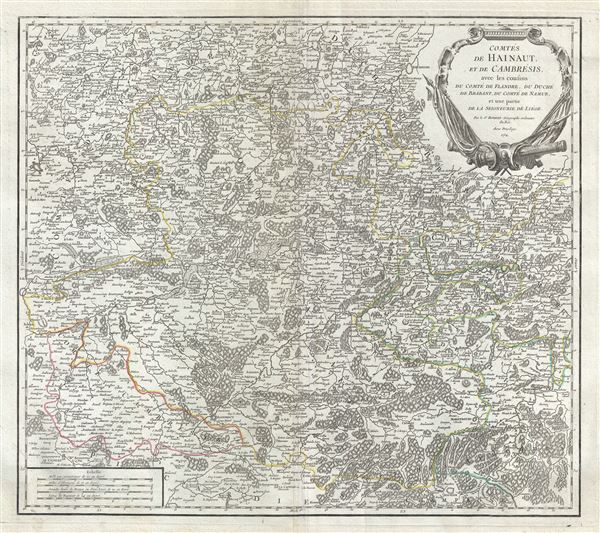 WE SELL ONLY ORIGINAL ANTIQUE MAPS - NOT REPRODUCTIONS Title: Comtes de Hainaut, et de Cambresis, avec les confins du Comte de Flandre, du Duche du Brabant, du Comte de Namur, et une partie de la Seigneurie de Liege. Description: This is an uncommon 1754 map of the western Belgium and northern France by Robert de Vaugondy. The map depicts part of modern day Belgium and France, which was at the time this map was made, part of the counties of Hainaut, Flanders, Cambrai, Namur, the Duchy of Brabant and Liege. It extends from Brussels in Belgium south to Hirson in France and from Douai east as far as Gembloux, Belgium. The entire region shows extraordinary detailed, offering both topographical and political information, with forests and mountains beautifully rendered in profile. The County of Hainaut, an historical lordship within the Holy Roman Empire, was an important region of the Low Counties and was ruled by the Spanish Habsburgs until 1714. It would be ceded to the French in 1797. A beautifully engraved title cartouche adorns the top right quadrant. Issued in the 1757 issue of the Atlas Universal. The Atlas Universal was one of the first atlases based upon actual surveys. Therefore, this map is highly accurate (for the period) and has most contemporary town names correct, though historic names are, in many cases, incorrect or omitted. Size: Printed area measures 20 inches high by 22 inches wide. Condition: Very good. Minor wear and creasing along original centerfold. Original platemark visible. Some spotting and offsetting. Shipping: Shipping rates are not negotiable. Items are shipped within three business days of receiving payment. We are happy to consolidate shipping where possible. The following shipping options are available: 1. FedEx Overnight (45 USD). USA Only. Signature Required. Customs: International buyers are responsible for paying duty and taxes on delivery. DHL or FedEx will contact the buyer by telephone to arrange tax payment if it is levied. Duty varies by country and we cannot predict the amount you will be charged. Some countries are duty free, others are not. Typically, a customs duty and/or VAT tax will be assessed on all parcels to continental Europe. Sometimes duty or tax is due in China, but is seems very random. Hong Kong, Singapore, Korea, and Taiwan have never assessed duty on a map we shipped. Maps shipped to the UK should be duty free as educational materials, but from time to time duty of 5% is assessed incorrectly by the UK customs agents. Insurance: All shipments are insured privately against loss and damage. All of our shipments require a signature for insurance purposes. If you have any questions please feel free to email us through eBay. Other Services Conservation Framing: Geographicus recommends basic conservation framing services for any antique paper. We do not offer this service. |
