1965 USGS Geologic Map of the Moon: Riphaeus Mountains 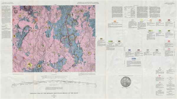 WE SELL ONLY ORIGINAL ANTIQUE MAPS - NOT REPRODUCTIONS Title: Geologic Map of the Riphaeus Mountains Region of the Moon by R. E. Eggleton. Description: A full color Geologic Map of the Riphaeus Mountains Region of the Moon by the U.S. Geological Survey, as fascinating for its sectional view as for its map. The Riphaeus Mountains, aka Montes Riphaeus, lie along the Mare Cognitum, or 'sea that is known,' (so named for the number of space probes that had landed there -- Luna 5, Ranger 7, Surveyor 3, Apollo 12). This Mare lies on the Oceanus Procellarum, or 'Ocean of Storms.' It includes a number of slender ridge lines with valleys flooded by intruding flows of lava. This lunar mountain range was named after the Riphean Mountains, described by authors of classical antiquity (Aristotle, Hippocrates, and Ptolemy, among others) as snow covered, but whose location seemed to vary from author to author. They may have been the Alps or the Urals. It is believed that most of the moon's craters were formed approximately 3.9 billion years ago, during a period of intense bombardment in the Inner Solar System. The cratering rate fluctuates as collisions in the asteroid belt send fragment clusters into the Inner Solar System. This map might show hypervelocity impact craters caused by the same cluster of asteroids that, 65 million years ago, caused the extinction of the dinosaurs. As humans wouldn't land on the moon until 1969, how were we able to map its geology? The map's extraordinarily detailed metadata explains that the cartographers used photos, and observations from optical and radio telescopes, with relief created by measuring shadows, combined with an assumed sun angle and an assumed base elevation. The geology was arrived at from observing differences in, and layering of, topographical forms, and in varying albedo (amount of reflected sunlight), both of which indicate different underlying materials formed under different processes. Goals of this work included the identification of suitable moon landing locations, and sources of oxygen for possible in establishing a more permanent lunar base. The map's sectional view (from the side) is one of the most detailed of the entire series, and provides a Rosetta stone for understanding these maps and how they were made. The map also contains detailed ‘metadata' explaining the mapmaking methodologies and symbols employed, and an index map showing the area's location on the Moon. This map series represents a breath-taking leap forward not only in selenography (the study of the moon), begun in the late 1400s, but also in the record of humankind's fearless exploration of the world(s) around and beyond us. This map would be a great companion piece to the other maps in the Geologic Atlas of the Moon,. It would also wonderfully complement early explorers' maps, or any of the plates from Burritt's famous 1856 Atlas to Illustrate the Geography of the Heavens , one of writer H.P. Lovecraft's most prized possessions. Created in 1965 by R.e. eggleton and published as plate I-458 in the United States Geological Survey's Geological Atlas of the Moon. Size: Printed area measures 29 inches high by 51 inches wide. Condition: Very Good. Shipping: Shipping rates are not negotiable. Items are shipped within three business days of receiving payment. We are happy to consolidate shipping where possible. The following shipping options are available: 1. FedEx Overnight (45 USD). USA Only. Signature Required. Customs: International buyers are responsible for paying duty and taxes on delivery. DHL or FedEx will contact the buyer by telephone to arrange tax payment if it is levied. Duty varies by country and we cannot predict the amount you will be charged. Some countries are duty free, others are not. Typically, a customs duty and/or VAT tax will be assessed on all parcels to continental Europe. Sometimes duty or tax is due in China, but is seems very random. Hong Kong, Singapore, Korea, and Taiwan have never assessed duty on a map we shipped. Maps shipped to the UK should be duty free as educational materials, but from time to time duty of 5% is assessed incorrectly by the UK customs agents. Insurance: All shipments are insured privately against loss and damage. All of our shipments require a signature for insurance purposes. If you have any questions please feel free to email us through eBay. Other Services Conservation Framing: Geographicus recommends basic conservation framing services for any antique paper. We do not offer this service. |
