1750 Vaugondy Map of Northeast Italy (Venice, Mantua) 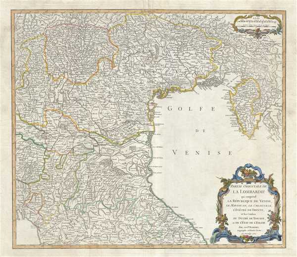 WE SELL ONLY ORIGINAL ANTIQUE MAPS - NOT REPRODUCTIONS Title: Partie Orientale de la Lombardie qui comprend la Republique de Venise, le Mantouan, le Cremonese, l'Eveche de Trente, et les confins du Duche de Toscane, et de l'Etat de l'Eglise. Description: This is an attractive 1750 map of northeastern Italy by Robert de Vaugondy. It covers from Tyrol south past Tuscany and Florence to Pisa and east as far as the Kvarner Gulf. The map renders the entire region in extraordinary detail offering both topographical and political information. The map depicts the Veneto region and its vicinity during the decline of the Republic of Venice. Italy at this time was a diverse assortment of fiefdoms, religious statelets, and republics in the process of sloughing of rigid control of powerful renaissance dynasties. This process would culminate in the French invasion of northern Italy and the creation of the Kingdom of Italy in 1804. A beautifully engraved title cartouche is included in the lower right quadrant of the map. This map was drawn by Robert de Vaugondy in 1750 and published in the 1757 issue of his Atlas Universal. The Atlas Universal was one of the first atlases based upon actual surveys. Therefore, this map is highly accurate (for the period) and has most contemporary town names correct. Size: Printed area measures 20 inches high by 23 inches wide. Condition: Very good. Minor wear along original centerfold. Original platemark visible. Minor spotting and offsetting, especially over margins. Shipping: Shipping rates are not negotiable. Items are shipped within three business days of receiving payment. We are happy to consolidate shipping where possible. The following shipping options are available: 1. FedEx Overnight (45 USD). USA Only. Signature Required. Customs: International buyers are responsible for paying duty and taxes on delivery. DHL or FedEx will contact the buyer by telephone to arrange tax payment if it is levied. Duty varies by country and we cannot predict the amount you will be charged. Some countries are duty free, others are not. Typically, a customs duty and/or VAT tax will be assessed on all parcels to continental Europe. Sometimes duty or tax is due in China, but is seems very random. Hong Kong, Singapore, Korea, and Taiwan have never assessed duty on a map we shipped. Maps shipped to the UK should be duty free as educational materials, but from time to time duty of 5% is assessed incorrectly by the UK customs agents. Insurance: All shipments are insured privately against loss and damage. All of our shipments require a signature for insurance purposes. If you have any questions please feel free to email us through eBay. Other Services Conservation Framing: Geographicus recommends basic conservation framing services for any antique paper. We do not offer this service. |
