1871 Sikkel Manuscript Map of Australia and New Zealand 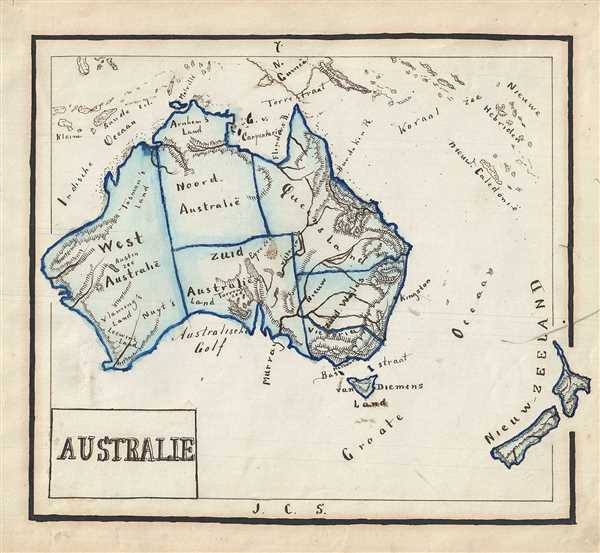 WE SELL ONLY ORIGINAL ANTIQUE MAPS - NOT REPRODUCTIONS Title: Australie. Description: This is an attractive 1871 manuscript map of Australia and New Zealand hand-drawn by J. C. Sikkel. It covers the entire continent in beautiful detail, including Van Diemen’s Land or Tanzania and New Zealand. Notes the Australian states of West Australia, North Australia, South Australia, Queensland, New South Wales and Victoria. Throughout, the map notes impressive topography and identifies cities, seas, islands, etc. Features wonderful and whimsical overall presentation. This map was drawn in 1871 by J.C. Sikkel as part of Der Atlas Geheele Aarde. Size: Printed area measures 8 inches high by 9.5 inches wide. Condition: Very good. Minor spotting. Title pasted onto sheet. Shipping: Shipping rates are not negotiable. Items are shipped within three business days of receiving payment. We are happy to consolidate shipping where possible. The following shipping options are available: 1. FedEx Overnight (45 USD). USA Only. Signature Required. Customs: International buyers are responsible for paying duty and taxes on delivery. DHL or FedEx will contact the buyer by telephone to arrange tax payment if it is levied. Duty varies by country and we cannot predict the amount you will be charged. Some countries are duty free, others are not. Typically, a customs duty and/or VAT tax will be assessed on all parcels to continental Europe. Sometimes duty or tax is due in China, but is seems very random. Hong Kong, Singapore, Korea, and Taiwan have never assessed duty on a map we shipped. Maps shipped to the UK should be duty free as educational materials, but from time to time duty of 5% is assessed incorrectly by the UK customs agents. Insurance: All shipments are insured privately against loss and damage. All of our shipments require a signature for insurance purposes. If you have any questions please feel free to email us through eBay. Other Services Conservation Framing: Geographicus recommends basic conservation framing services for any antique paper. We do not offer this service. |
