1865 Stokes Admiralty Map of Eastern Australia: Cape Howe to Barriga Point 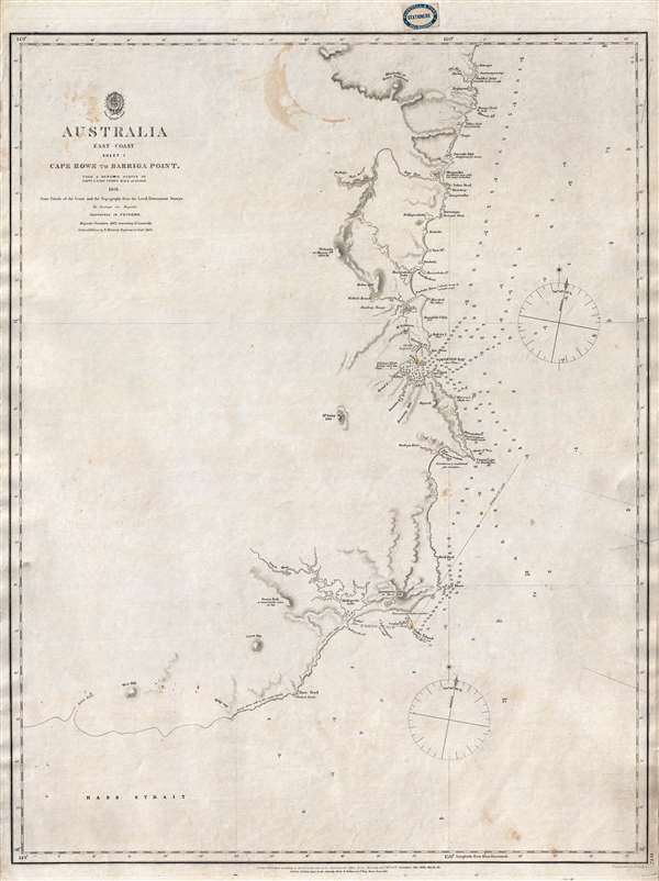 WE SELL ONLY ORIGINAL ANTIQUE MAPS - NOT REPRODUCTIONS Title: Australia East Coast Sheet I Cape Howe to Barriga Point. Description: This is an extremely rare 1865 map of eastern Australia covering from Cape Howe to Barriga Point. It extends north as far as Mount Townsend and south to Bass Strait. Includes the popular resort of Mallacoota, Twofold Bay, Boyd, and Eden. There are copious annotations regarding breakers, fords, tides, and other information useful to the mariner. This is one of the earliest large scale Nautical charts provide scientifically surveyed hydrographic detail for a significant portion of the Australian coast. Nonetheless, the ghosted in southern part of the map, along Bass Strait, reveals celery just how much of the Australian coast remained incompletely mapped. This chart is the result of marine surveys completed by Commander John Lort Stokes and the HMS Acheron. This map was printed by John Walker for the British Admiralty Hydrographic Office as chart number 2141. The original seller for this chart appears to have been J. D. Potter, of King Street, Tower Hill, London. It subsequently found its way to Melbourne, Australia, where it was sold by Blundell and Ford, Agents for the sale of Admiralty Charts. The chart was originally published in 1852. Updated states were issued in 1863 and, as here, 1865. All examples of this chart in all editions are extremely rare. We have identified two other examples of this chart, one housed in the National Library of Australia and another at the e Beinecke Library, Yale University. We are aware of one additional example of the 1865 state in private hands. Size: Printed area measures 26 inches high by 19.5 inches wide. Condition: Very good. Minor repairs upper right margin. Separate issue. Seller's stamp, top margin. Some pen marks related to navigational use. Shipping: Shipping rates are not negotiable. Items are shipped within three business days of receiving payment. We are happy to consolidate shipping where possible. The following shipping options are available: 1. FedEx Overnight (45 USD). USA Only. Signature Required. Customs: International buyers are responsible for paying duty and taxes on delivery. DHL or FedEx will contact the buyer by telephone to arrange tax payment if it is levied. Duty varies by country and we cannot predict the amount you will be charged. Some countries are duty free, others are not. Typically, a customs duty and/or VAT tax will be assessed on all parcels to continental Europe. Sometimes duty or tax is due in China, but is seems very random. Hong Kong, Singapore, Korea, and Taiwan have never assessed duty on a map we shipped. Maps shipped to the UK should be duty free as educational materials, but from time to time duty of 5% is assessed incorrectly by the UK customs agents. Insurance: All shipments are insured privately against loss and damage. All of our shipments require a signature for insurance purposes. If you have any questions please feel free to email us through eBay. Other Services Conservation Framing: Geographicus recommends basic conservation framing services for any antique paper. We do not offer this service. |
