1949 Denis Mason Jones Pictorial Map of Leeds, England 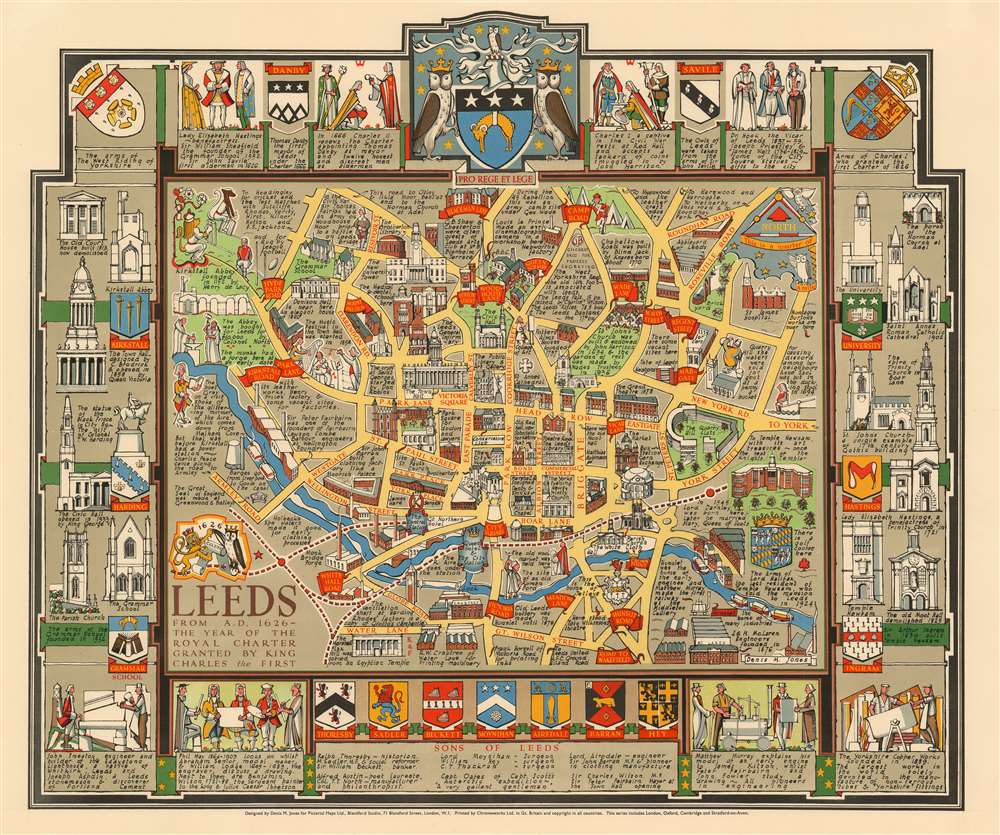 WE SELL ONLY ORIGINAL ANTIQUE MAPS - NOT REPRODUCTIONS Title: Leeds from A.D. 1626 - the year of the Royal Charter granted by King Charles the First. Description: A rare and stunning 1948 pictorial map of Leeds, England by the architect and artist Denis M. Jones. This is probably Jones' first pictorial map, it covers Jones' hometown of Leeds from Water Lane and Great Wilson Street to Blackman Lane and Rondhay Road. Important buildings are rendered in profile with the Civic Hall at center. The River Aire appears prominently at center. The map is surrounded by heralding imagery and the profiles of important Leeds buildings. The armorial crest of the city of Leeds appears at top center. Publication History and CensusThe map was drawn by Denis M. Jones during a brief period following World War II when he lived in London with the pictorial mapmaker and publisher Kerry Lee. The map was published c. 1948 by Lee's company, Pictorial Maps Ltd. It was printed in Great Britain by Chromoworks Ltd. This is part of a series of pictorial maps, most by Lee, depicting English cities.Compared to other maps issued by Pictorial Maps Ltd. this map appears to be extremely rare, with only 2 other examples known, one owned by Roderick Barron, the other by the collector David Rumsey. There are no recorded institutional holdings. Size: Printed area measures 20.5 inches high by 24.5 inches wide. Condition: Very good. Shipping: Shipping rates are not negotiable. Items are shipped within three business days of receiving payment. We are happy to consolidate shipping where possible. The following shipping options are available: 1. FedEx Overnight (45 USD). USA Only. Signature Required. Customs: International buyers are responsible for paying duty and taxes on delivery. DHL or FedEx will contact the buyer by telephone to arrange tax payment if it is levied. Duty varies by country and we cannot predict the amount you will be charged. Some countries are duty free, others are not. Typically, a customs duty and/or VAT tax will be assessed on all parcels to continental Europe. Sometimes duty or tax is due in China, but is seems very random. Hong Kong, Singapore, Korea, and Taiwan have never assessed duty on a map we shipped. Maps shipped to the UK should be duty free as educational materials, but from time to time duty of 5% is assessed incorrectly by the UK customs agents. Insurance: All shipments are insured privately against loss and damage. All of our shipments require a signature for insurance purposes. If you have any questions please feel free to email us through eBay. Other Services Conservation Framing: Geographicus recommends basic conservation framing services for any antique paper. We do not offer this service. |
