1900 Tarchi and Pineider Pictorial City Map or Plan of Florence, Italy 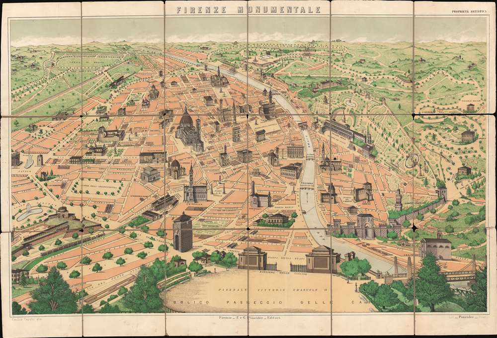 WE SELL ONLY ORIGINAL ANTIQUE MAPS - NOT REPRODUCTIONS Title: Firenze Monumentale. Description: This is a c. 1900 Emilio Tarchi pictorial tourist map of Florence, Italy highlighting the historic city's most iconic buildings. Beautifully rendered, the map depicts the city from the Piazza Cavour to the Porta Romana and from the Viale Michelangiolo to the Piazzale Vittorio Emanuele II. The Cathedral of Santa Maria del Fiore, the Basilica of Santa Croce, and the Palazzo Vecchio are only a few of Florence's celebrated architecture illustrated here. Numerous other buildings are illustrated in a cadastral manner, including the Uffizi Gallery next to the Palazzo Vecchio and the Ponte Vecchio. Others, like the Museum of Natural History, are simply labeled. Roads and plazas throughout the city are identified, including those in the parks surrounding the city. Publication HistoryThis map was drawn by Emilio Tarchi and published by Giuseppe Pineider c. 1900. We are aware of at least two different editions of this map, with the second appearing much like the current example, only with the addition of Florence's tramways.Size: Printed area measures 19 inches high by 28 inches wide. Condition: Good. Dissected and mounted on linen in eighteen panels. Wear along original fold lines. Verso reinforcements along original fold lines. Text on verso. Shipping: Shipping rates are not negotiable. Items are shipped within three business days of receiving payment. We are happy to consolidate shipping where possible. The following shipping options are available: 1. FedEx Overnight (45 USD). USA Only. Signature Required. Customs: International buyers are responsible for paying duty and taxes on delivery. DHL or FedEx will contact the buyer by telephone to arrange tax payment if it is levied. Duty varies by country and we cannot predict the amount you will be charged. Some countries are duty free, others are not. Typically, a customs duty and/or VAT tax will be assessed on all parcels to continental Europe. Sometimes duty or tax is due in China, but is seems very random. Hong Kong, Singapore, Korea, and Taiwan have never assessed duty on a map we shipped. Maps shipped to the UK should be duty free as educational materials, but from time to time duty of 5% is assessed incorrectly by the UK customs agents. Insurance: All shipments are insured privately against loss and damage. All of our shipments require a signature for insurance purposes. If you have any questions please feel free to email us through eBay. Other Services Conservation Framing: Geographicus recommends basic conservation framing services for any antique paper. We do not offer this service. |
