1764 Seutter and Lotter Nautical Flag Chart 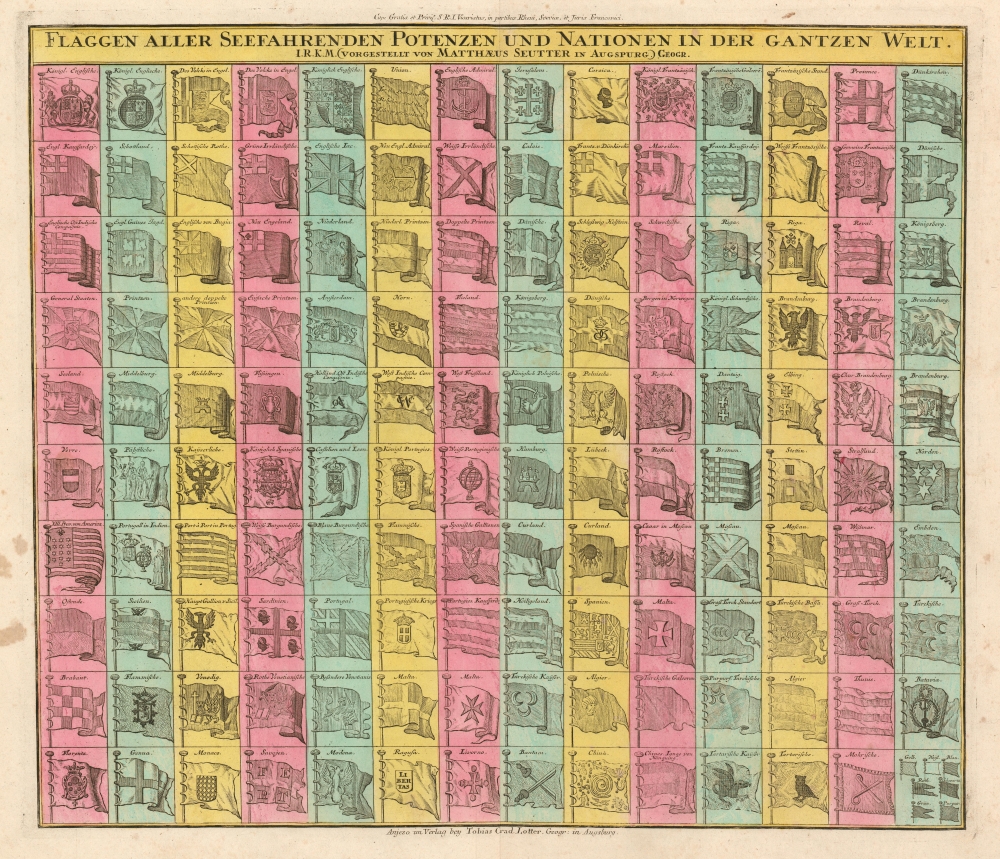 WE SELL ONLY ORIGINAL ANTIQUE MAPS - NOT REPRODUCTIONS Title: Flaggen aller Seefahrenden Potenzen und Nationen in der gantzen Welt. Description: A very attractive c. 1765 flag chart issued by Matthias Seutter and Tobias Conrad Lotter. The flag features 139 flags of various nations, factions, and trading companies. Among the more interesting flags are those of the Dutch West India Company (G.W.C. /Geoctroyeerde Westindische Compagnie) and the Dutch East India Company (V.O.C. / Vereenigde Oostindische Compagnie). The premier placement of English flags in the upper left quadrant suggest that this chart may have been copied from an English source. Dragon Flag of ChinaAt bottom center the flag of Empire of China (Sina) stands out. It appears as a great whirlpool surrounded by eight decorations. This is most likely based upon an image of the Chinese flag appearing in Carl Allard's 1705 Dutch flag book, Niewe Hollandse Scheeps Bouw. In fact, it is a misinterpretation of the Qing flag, a dragon on a yellow field with eight banners. However, European mapmakers, likely having never seen a Chinese flag, interpreted the dragon to the best of their ability.Census and Publication HistoryThis map is probably derived from a Dutch flag chart issued by Danckerts c. 1700. The chart was picked up by J. B. Homann, who issued in own variant c. 1710. When Seutter left the Homann firm early in the 18th century, he may have taken this plate with him or simply copied it. Seutter issued his own variant sometime after 1737, as the chart notes his privilege, a kind of early copyright suggestive of royal patronage, at top center. After the 1762 death of Seutter's son, Albrecht Carl Seutter, the plate for this map was acquired by Tobias Conrad Lotter, Matthias Seutter's son in law, who added his own imprint at bottom center – as in the present example.Size: Printed area measures 19.25 inches high by 22.25 inches wide. Condition: Very good. Shipping: Shipping rates are not negotiable. Items are shipped within three business days of receiving payment. We are happy to consolidate shipping where possible. The following shipping options are available: 1. FedEx Overnight (45 USD). USA Only. Signature Required. Customs: International buyers are responsible for paying duty and taxes on delivery. DHL or FedEx will contact the buyer by telephone to arrange tax payment if it is levied. Duty varies by country and we cannot predict the amount you will be charged. Some countries are duty free, others are not. Typically, a customs duty and/or VAT tax will be assessed on all parcels to continental Europe. Sometimes duty or tax is due in China, but is seems very random. Hong Kong, Singapore, Korea, and Taiwan have never assessed duty on a map we shipped. Maps shipped to the UK should be duty free as educational materials, but from time to time duty of 5% is assessed incorrectly by the UK customs agents. Insurance: All shipments are insured privately against loss and damage. All of our shipments require a signature for insurance purposes. If you have any questions please feel free to email us through eBay. Other Services Conservation Framing: Geographicus recommends basic conservation framing services for any antique paper. We do not offer this service. |
