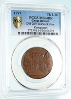
England - Warwickshire - Coventry - Conder Token
P. Kempson Half Penny
1797 Copper Half Penny 28mm
Reference: D&H# 269
Certification: PCGS MS 64 BN 571546.64/36466393
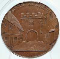
COOK STREET GATE, Facade of castle gate, houses in front.
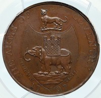
THE ARMS OF COVENTRY PKEMPSON FECIT. 1797, Leopard above shield, elephant carrying castle turret within.
You are bidding on the exact item pictured, provided with a Certificate of Authenticity and Lifetime Guarantee of Authenticity.
 Coventry is a city and metropolitan borough in the centre of England. It has been the capital of England more than once in the 15th century when the seat of Government was held in Coventry. Coventry's outstanding heritage includes three cathedrals. Coventry is a city and metropolitan borough in the centre of England. It has been the capital of England more than once in the 15th century when the seat of Government was held in Coventry. Coventry's outstanding heritage includes three cathedrals.
Coventry is located in the county of West Midlands in England. Historically Coventry has been its own county and part of Warwickshire. Coventry is the 10th-largest city in England and the 12th-largest UK city overall. It is also the second largest city in the West Midlands region, after Birmingham, with a population of 329,810 in 2013. Coventry is an ancient settlement that predates Birmingham and Leicester. Coventry is situated 95 miles (153 km) northwest of central London, 19 miles (31 km) east-south-east of Birmingham, 24 miles (39 km) southwest of Leicester and 10 miles (16 km) north of Warwick. It is further from the coast than any other city in Britain. Although harbouring a population of almost a third-of-a-million inhabitants, Coventry is not amongst the English Core Cities Group due to its proximity to Birmingham. Approximately half a million people live within 10 miles (16 km) of Coventry city centre. Coventry was the world's first twin city, when it formed a twinning relationship with the Russian city of Stalingrad (now Volgograd) during World War II. The relationship developed through ordinary people in Coventry who wanted to show their support for the Soviet Red Army during the Battle of Stalingrad. The city is now also twinned with Dresden, Lidice, Saint-?ienne and 22 other cities around the world. A part of the city centre at the entrance to the Lower Precinct is named Lidice Place. Coventry Cathedral is one of the newer cathedral buildings, having been built after the destruction of the fourteenth-century cathedral church of Saint Michael by the German Luftwaffe on 14 November 1940. Coventry motor companies have contributed significantly to the British motor industry. The city has two universities, the city centre-based Coventry University and the University of Warwick on the southern outskirts.
Conder Tokens, also known as 18th Century Provincial Tokens, are a form of privately minted token coinage struck and used during the latter part of the 18th Century and the early part of the 19th Century in England, Anglesey and Wales, Scotland, and Ireland. The driving force behind the need for token coinage was the shortage of small denomination coins for everyday transactions. However, the demand was fueled by other factors such as the Industrial Revolution, population growth, and the preponderance of counterfeit circulating coins. Because the government made little effort to ameliorate this shortage, private business owners and merchants took matters into their own hands, and the first tokens of this type were issued in 1787 to pay workers at the Parys Mine Company. By 1795, millions of tokens of a few thousand varying designs had been struck and were in common use throughout Great Britain. Collecting Conder tokens has been popular since shortly after they were first manufactured, resulting in the availability today of many highly preserved examples for collectors. The demarcation of what is or is not considered a Conder token is somewhat unclear; however, most collectors consider Conder tokens to include those indexed originally by James Conder or later by Dalton & Hamer.
 Warwickshire is a county in the West Midlands region of England. The county town is Warwick, and the largest town is Nuneaton. The county is famous for being the birthplace of William Shakespeare. Warwickshire is a county in the West Midlands region of England. The county town is Warwick, and the largest town is Nuneaton. The county is famous for being the birthplace of William Shakespeare.
The county is divided into five districts of North Warwickshire, Nuneaton and Bedworth, Rugby, Warwick and Stratford-on-Avon. The current county boundaries were set in 1974 by the Local Government Act 1972. The historic county boundaries include Coventry, Sutton Coldfield and Solihull, as well as much of Birmingham. The county is bordered by Leicestershire to the northeast, Staffordshire to the northwest, Worcestershire and the West Midlands to the west, Northamptonshire to the east and southeast, Gloucestershire to the southwest and Oxfordshire to the south. The northern tip of the county is only 3 miles (5 km) from the Derbyshire border. An average-sized English county covering an area of almost 2,000 km2, it runs some 60 miles (97 km) north to south. Equivalently it extends as far north as Shrewsbury in Shropshire and as far south as Banbury in north Oxfordshire.  The majority of Warwickshire's population live in the north and centre of the county. The market towns of northern and eastern Warwickshire were industrialised in the 19th century, and include Atherstone, Bedworth, Nuneaton, and Rugby. Of these, Atherstone has retained most of its original character. Major industries included coal mining, textiles, engineering and cement production, but heavy industry is in decline, being replaced by distribution centres, light to medium industry and services. Of the northern and eastern towns, only Nuneaton and Rugby (as the birthplace of rugby football) are well known outside of Warwickshire. The prosperous towns of central and western Warwickshire including Royal Leamington Spa, Warwick, Stratford-upon-Avon, Kenilworth, Alcester, Southam and Wellesbourne harbour light to medium industries, services and tourism as major employment sectors. The majority of Warwickshire's population live in the north and centre of the county. The market towns of northern and eastern Warwickshire were industrialised in the 19th century, and include Atherstone, Bedworth, Nuneaton, and Rugby. Of these, Atherstone has retained most of its original character. Major industries included coal mining, textiles, engineering and cement production, but heavy industry is in decline, being replaced by distribution centres, light to medium industry and services. Of the northern and eastern towns, only Nuneaton and Rugby (as the birthplace of rugby football) are well known outside of Warwickshire. The prosperous towns of central and western Warwickshire including Royal Leamington Spa, Warwick, Stratford-upon-Avon, Kenilworth, Alcester, Southam and Wellesbourne harbour light to medium industries, services and tourism as major employment sectors.
The north of the county, bordering Staffordshire and Leicestershire, is mildly undulating countryside and the northernmost village, No Man's Heath, is only 34 miles (55 km) south of the Peak District National Park's southernmost point. The south of the county is largely rural and sparsely populated, and includes a very small area of the Cotswolds, at the border with northeast Gloucestershire. The plain between the outlying Cotswolds and the Edgehill escarpment is known as the Vale of Red Horse. The only town in the south of Warwickshire is Shipston-on-Stour. The highest point in the county, at 261 m (856 ft), is Ebrington Hill, again on the border with Gloucestershire, grid reference SP187426 at the county's southwest extremity. There are no cities in Warwickshire since both Coventry and Birmingham were incorporated into the West Midlands county in 1974 and are now metropolitan authorities in themselves. The largest towns in Warwickshire in 2011 were: Nuneaton (pop. 81,900), Rugby (70,600), Leamington Spa (49,500), Bedworth (32,500), Warwick (30,100), Stratford (25,500) and Kenilworth (22,400).
|