1883 Imray Nautical Map of the Pacific Northwest: Washington, Vancouver, etc. 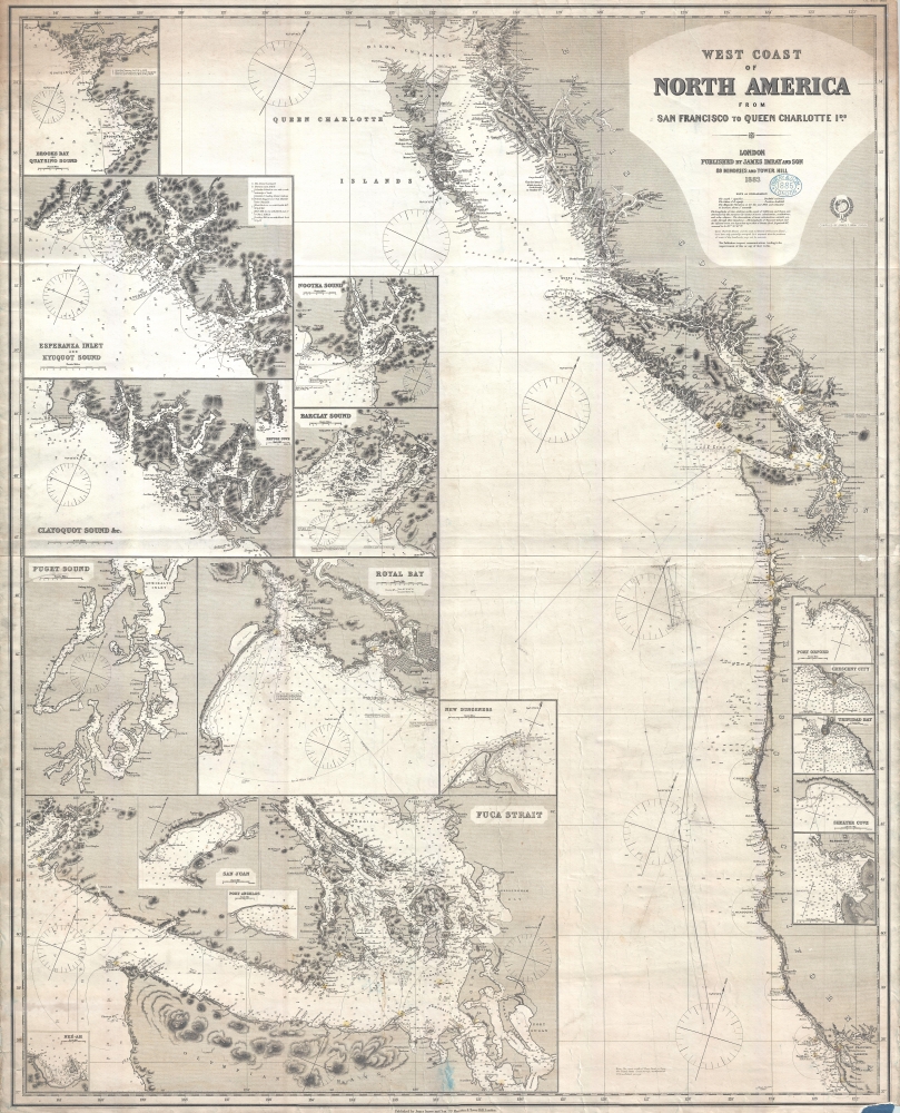 WE SELL ONLY ORIGINAL ANTIQUE MAPS - NOT REPRODUCTIONS Title: West Coast of North America from San Francisco to Queen Charlotte Ids. Description: A finely executed 1883 James Imray working nautical chart or maritime map illustrating the American Pacific Northwest from San Francisco to the Queen Charlotte Islands. The map includes San Francisco Bay, Vancouver Island, the Strait of Juan de Fuca, the Columbia River and Astoria, and the coasts of Washington, Oregon, northern California, and British Columbia. Pencil manuscript annotations illustrate the route of a merchant ship, probably a fur trader, between the Columbia River frontier trading settlement of Astoria and San Francisco. A Wealth of InsetsThe map features 18 inset detailed sub-maps including Fuca Strait, Neé-ah, San Juan, Port Angelos, Puget Sound, Royal Bay, Clayoquot Sound, Barclay Sound, Nootka Sound, Esperanza Inlet and Kyuquot Sound, Broods Bay and Quatsino Sound, Burrard Inlet, Port Orford, Crescent City, Trinidad Bay, Shelter Cove, Mendocino, and Fort Ross Cove.A Change in Branding BluebacksThis chart is part of a series of large format nautical charts issued by James Imray and Sons in the early 1880s. The charts were part of a branding change that introduced greater consistency in style, size, and form to the previously mishmash that marked earlier blueback chart production. The new style focused on producing charts of a uniform size with standardized shading and mapping conventions. Without a doubt these changes were intended to make Imray nautical charts more competitive with cheaper, often more accurate, British Admiralty charts.Blueback ChartsBlueback nautical charts began appearing in London in the late 18th century. Bluebacks, as they came to be called, were privately published large format nautical charts known for their distinctive blue paper backing. The backing, a commonly available blue manila paper traditionally used by publishers to warp unbound pamphlets, was adopted as a practical way to reinforce the low-quality paper used by private chart publishers in an effort to cut costs. The earliest known blueback charts include a 1760 chart issued by Mount and Page, and a 1787 chart issued by Robert Sayer. The tradition took off in the early 19th century, when British publishers like John Hamilton Moore, Robert Blachford, James Imray, William Heather, John William Norie, Charles Wilson, David Steel, R. H. Laurie, and John Hobbs, among others, rose to dominate the chart trade. Bluebacks became so popular that the convention was embraced by chartmakers outside of England, including Americans Edmund March Blunt and George Eldridge, as well as Scandinavian, French, German, Russian, and Spanish chartmakers. Blueback charts remained popular until the late 19th century, when government subsidized organizations like the British Admiralty Hydrographic Office and the United States Coast Survey, began issuing their own superior charts on high quality paper that did not require reinforcement.Size: Printed area measures 50.5 inches high by 41 inches wide. Condition: Very good. Minor soiling. Overall toning. Chip lower right. Pencil annotations related to navigation. Working nautical chart. Items are shipped within three business days of receiving payment. 1. USA Only. Signature Required. Customs: International buyers are responsible for paying duty and taxes on delivery. DHL or FedEx will contact the buyer by telephone to arrange tax payment if it is levied. Duty varies by country and we cannot predict the amount you will be charged. Some countries are duty free, others are not. Typically, a customs duty and/or VAT tax will be assessed on all parcels to continental Europe. Sometimes duty or tax is due in China, but is seems very random. Hong Kong, Singapore, Korea, and Taiwan have never assessed duty on a map we shipped. Maps shipped to the UK should be duty free as educational materials, but from time to time duty of 5% is assessed incorrectly by the UK customs agents. Insurance: All shipments are insured privately against loss and damage. All of our shipments require a signature for insurance purposes. If you have any questions please feel free to email us through eBay. Other Services Conservation Framing: Geographicus recommends basic conservation framing services for any antique paper. We do not offer this service. |
