1835 Burr Map of New York City and Vicinity (25 miles around) 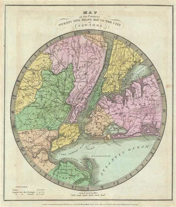 WE SELL ONLY ORIGINAL ANTIQUE MAPS - NOT REPRODUCTIONS Title: Map of the Country Twenty Five Miles Round the City of New York. Description: This is an appealing 1835 first edition map of New York City and its vicinity by David H. Burr. It extends twenty-five miles around New York City, covering from Rockland County to Monmouth in New Jersey and from Morris County east as far as Hempstead. Reveals the area in considerable detail with attention to roads, rivers, swamps, bays, rivers, islands and a host of other topographical features. Some coastal features are also detailed. According to Ristow, although Burr is credited on the title page, he left this atlas incomplete. He was appointed as topographer to the U.S. Post Office, and of the sixty-three maps finally included in this atlas, only completed eight. The rest of the maps were then completed by Illman and Pilbrow in Burr's style. This map was ‘Entered according to act of Congress Nov. 11th in the year 1835 by Thomas Illman in the Clerk’s office of the District Court for the Southern District of New York’. Published by D. S. Stone in Burr’s New Universal Atlas. Size: Printed area measures 13.5 inches high by 11.5 inches wide. Condition: Very good. Minor foxing. Original platemark visible. Left side remargined. Items are shipped within three business days of receiving payment. 1. USA Only. Signature Required. Customs: International buyers are responsible for paying duty and taxes on delivery. DHL or FedEx will contact the buyer by telephone to arrange tax payment if it is levied. Duty varies by country and we cannot predict the amount you will be charged. Some countries are duty free, others are not. Typically, a customs duty and/or VAT tax will be assessed on all parcels to continental Europe. Sometimes duty or tax is due in China, but is seems very random. Hong Kong, Singapore, Korea, and Taiwan have never assessed duty on a map we shipped. Maps shipped to the UK should be duty free as educational materials, but from time to time duty of 5% is assessed incorrectly by the UK customs agents. Insurance: All shipments are insured privately against loss and damage. All of our shipments require a signature for insurance purposes. If you have any questions please feel free to email us through eBay. Other Services Conservation Framing: Geographicus recommends basic conservation framing services for any antique paper. We do not offer this service. |
