1852 Lavasseur Map of Turkey in Asia 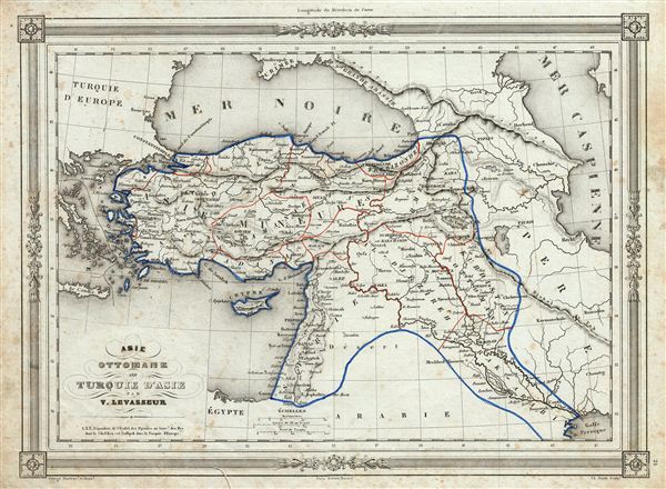 WE SELL ONLY ORIGINAL ANTIQUE MAPS - NOT REPRODUCTIONS Title: Asie Ottomane ou Turquie d'Asie. Description: An uncommon and extremely attractive 1852 map of Turkey in Asia by Victor Levasseur. The map covers the Asian territories claimed by the Turkish Ottoman empire c. 1850 from the Black Sea to Arabia, including Cyprus. Centered on the Holy land (Palestine / Israel), the map covers the modern day countries of Turkey, Cyprus, Iraq, Israel, Palestine, Jordan, Lebanon, and Syria. Throughout, the map identifies various cities, towns, rivers and assortment of additional topographical details. The map to the last days of the Ottoman empire, whose influence, though rapidly declining, still dominated much of the Middle east. The map features a beautiful frame style border. Prepared by Victor Levasseur for publication as plate no. 21 in Maison Basset's 1852 edition of Atlas Illustre Destine a l'enseignement de la Geographie elementaire. Size: Printed area measures 10 inches high by 13 inches wide. Condition: Very good. Blank on verso. Minor foxing throughout. Shipping: Shipping rates are not negotiable. Items are shipped within three business days of receiving payment. We are happy to consolidate shipping where possible. The following shipping options are available: 1. FedEx Overnight (45 USD). USA Only. Signature Required. Customs: International buyers are responsible for paying duty and taxes on delivery. DHL or FedEx will contact the buyer by telephone to arrange tax payment if it is levied. Duty varies by country and we cannot predict the amount you will be charged. Some countries are duty free, others are not. Typically, a customs duty and/or VAT tax will be assessed on all parcels to continental Europe. Sometimes duty or tax is due in China, but is seems very random. Hong Kong, Singapore, Korea, and Taiwan have never assessed duty on a map we shipped. Maps shipped to the UK should be duty free as educational materials, but from time to time duty of 5% is assessed incorrectly by the UK customs agents. Insurance: All shipments are insured privately against loss and damage. All of our shipments require a signature for insurance purposes. If you have any questions please feel free to email us through eBay. Other Services Conservation Framing: Geographicus recommends basic conservation framing services for any antique paper. We do not offer this service. |
