1951 Miller Pictorial Map of Cape Cod 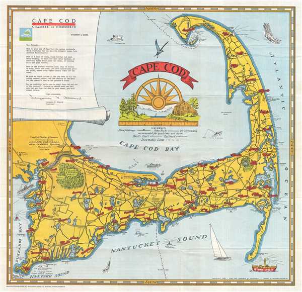 WE SELL ONLY ORIGINAL ANTIQUE MAPS - NOT REPRODUCTIONS Title: Cape Cod. Description: This is a William A. Miller Jr. pictorial map of Cape Cod from the Cape Cod Canal and Buzzards Bay to the Atlantic Ocean and from Race Point and Provincetown to Vineyard Sound and Nantucket Sound. Attractively colored and visually engaging, towns and villages throughout Cape Cod are labeled with red banners bearing the town names. Woods Hole, Falmouth, Hyannis, Barnstable, and Provincetown are among the labeled towns. Nickerson State Park and Shawme Forest are illustrated as pockets of green filled with trees and both are labeled. A pair of airplanes are depicted flying over Cape Cod, and a train is drawn passing the Hyannis airport on its way to Hyannis. A decorative title cartouche is situated in Cape Cod Bay and features part of a compass rose rising above an idyllic scene from a hamlet on Cape Cod. Boats, lighthouses, and various sea birds are included along, in, or flying above the water around the Cape, and the Pilgrim Monument is illustrated in Provincetown. A note extolling the natural beauty and serenity of Cape Cod written the Cape Cod Chamber of Commerce is printed in the upper left corner. This map was drawn by William A. Miller and published by the Cape Cod Chamber of Commerce in 1951. Size: Printed area measures 19.5 inches high by 20.25 inches wide. Condition: Very good. Light wear along original fold lines. Text on verso. Shipping: Shipping rates are not negotiable. Items are shipped within three business days of receiving payment. We are happy to consolidate shipping where possible. The following shipping options are available: 1. FedEx Overnight (45 USD). USA Only. Signature Required. Customs: International buyers are responsible for paying duty and taxes on delivery. DHL or FedEx will contact the buyer by telephone to arrange tax payment if it is levied. Duty varies by country and we cannot predict the amount you will be charged. Some countries are duty free, others are not. Typically, a customs duty and/or VAT tax will be assessed on all parcels to continental Europe. Sometimes duty or tax is due in China, but is seems very random. Hong Kong, Singapore, Korea, and Taiwan have never assessed duty on a map we shipped. Maps shipped to the UK should be duty free as educational materials, but from time to time duty of 5% is assessed incorrectly by the UK customs agents. Insurance: All shipments are insured privately against loss and damage. All of our shipments require a signature for insurance purposes. If you have any questions please feel free to email us through eBay. Other Services Conservation Framing: Geographicus recommends basic conservation framing services for any antique paper. We do not offer this service. |
