1914 Southern Pacific Railroad City Map or Plan of San Francisco, California 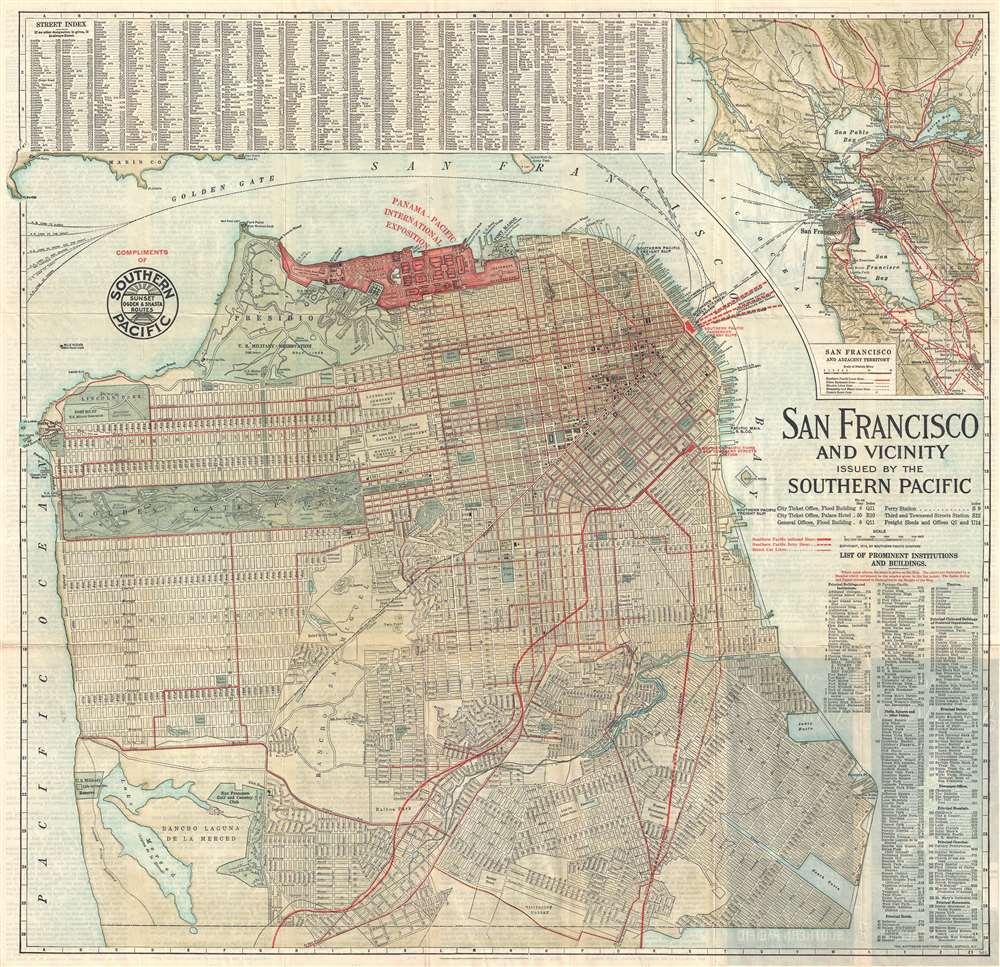 WE SELL ONLY ORIGINAL ANTIQUE MAPS - NOT REPRODUCTIONS Title: San Francisco and Vicinity Issued by the Southern Pacific. Description: An attractive first edition city map or plan of San Francisco, California, issued in 1914 by the Southern Pacific Railroad. The map covers the northern part of San Francisco Peninsula from Bellevue Street and Lake Merced to San Francisco Bay. The routes of the Southern Pacific Railroad are highlighted in red, emphasizing their utility in accessing the Panama-Pacific International Exposition. This, however, may not have been the case, as there is another depot near the exposition grounds tor ferries, operated by a competitor, that offers direct access to the fair. It is also important to note that the Exposition did not begin until February 1915, and this map was printed in 1914. Thus, it was created while the Panama-Pacific International Exposition was still in the planning phases. Geographically, the map offers impressive detail, all streets and numerous parks and public buildings are identified, even the individual links in the San Francisco Gold and Country Club are noted. Golden Gate Park and the Presidio Military Reservation are particularly well rendered. At the top of the map, the lands reserved for the Panama-Pacific International Exposition are marked and highlighted in red. The Panama-Pacific International Exposition (PPIE) was a world's fair held in San Francisco between February 20 and December 4, 1915. Ostensibly, the fair was intended to celebrate the completion of the Panama Canal, but it was also an opportunity for San Francisco to showcase its recovery from the 1906 earthquake. The fair was constructed on a 635-acre site (shaded in red) along the northern shore now known as the Marina District. Of course, at this time The Golden Gate and Oakland Bay Bridges have yet to be built. Street and building indexes surround the map proper. A more general map of the entire San Francisco Bay region appears in the upper right corner. This map was issued by the Southern Pacific Railroad, which contracted the Matthews-Northrup Works publishing firm of Buffalo to prepare and print the map. A second edition was issued in 1915. Size: Printed area measures 26 inches high by 27 inches wide. Condition: Very good. Verso repairs of fold separations. Text on verso. Shipping: Shipping rates are not negotiable. Items are shipped within three business days of receiving payment. We are happy to consolidate shipping where possible. The following shipping options are available: 1. FedEx Overnight (45 USD). USA Only. Signature Required. Customs: International buyers are responsible for paying duty and taxes on delivery. DHL or FedEx will contact the buyer by telephone to arrange tax payment if it is levied. Duty varies by country and we cannot predict the amount you will be charged. Some countries are duty free, others are not. Typically, a customs duty and/or VAT tax will be assessed on all parcels to continental Europe. Sometimes duty or tax is due in China, but is seems very random. Hong Kong, Singapore, Korea, and Taiwan have never assessed duty on a map we shipped. Maps shipped to the UK should be duty free as educational materials, but from time to time duty of 5% is assessed incorrectly by the UK customs agents. Insurance: All shipments are insured privately against loss and damage. All of our shipments require a signature for insurance purposes. If you have any questions please feel free to email us through eBay. Other Services Conservation Framing: Geographicus recommends basic conservation framing services for any antique paper. We do not offer this service. |
