1960 Aloha Airlines Pictorial Route Map of the Hawaiian Islands 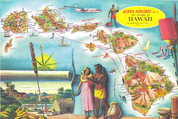 WE SELL ONLY ORIGINAL ANTIQUE MAPS - NOT REPRODUCTIONS Title: Aloha Airlines Map of the Islands of Hawaii. Description: This is a c. 1960 Aloha Airlines route map of the Hawaiian Islands. The map depicts seven of the main islands in the archipelago, including Hawaii, Maui, Lanai, Molokai, Oahu, Kauai, and Niihau. Of these seven, Lanai and Niihau are the least illustrated, bearing only one small vignette each and no labeled locations. Each of the other five, however, are highly detailed and richly illustrated. Numerous locations on each island are labeled, including cities, towns, points, swimming beaches, and other sites. Mauna Loa and Mauna Kea are both labeled on Hawaii, along with Hawaii Volcanoes National Park, and the cities of Hilo and Hawi. Haleakala National Park is illustrated on Maui, while Honolulu, Pearl Harbor, Waikiki Beach, and Diamond Head are labeled on Oahu. Each island bears illustrations of both livestock and wildlife, as well as lighthouses and airports (a major point of interest for an airline). Routes between these airports are illustrated in red, some of which stretch between the islands, while others simply connect two different airports on the same island (between Kona airport and Upolu airport on Hawaii). Each route's distance is included along the line, giving the viewer an idea of how far it is between the islands. Several large vignettes of life on the islands surround the archipelago, including a spearfisherman, what appears to be a scene of traditional island life, and various island artifacts. A Fairchild F-27 turboprop aircraft is illustrated along the top border. This map was created by Lonn Allison and published by Aloha Airlines c. 1960. Although undated, we are able to date this map by the presence of the Fairchild F-27. A cutting-edge aircraft at the time, Aloha Airlines took delivery of their first Fairchild F-27 on April 15, 1959, meaning that this brochure must post-date that delivery. This appears to be a relatively scarce piece, as we have been able to locate only one other example of this map bearing the illustration of the Fairchild F-27. Size: Printed area measures 12 inches high by 18 inches wide. Condition: Very good. Even overall toning. Text on verso. Shipping: Shipping rates are not negotiable. Items are shipped within three business days of receiving payment. We are happy to consolidate shipping where possible. The following shipping options are available: 1. FedEx Overnight (45 USD). USA Only. Signature Required. Customs: International buyers are responsible for paying duty and taxes on delivery. DHL or FedEx will contact the buyer by telephone to arrange tax payment if it is levied. Duty varies by country and we cannot predict the amount you will be charged. Some countries are duty free, others are not. Typically, a customs duty and/or VAT tax will be assessed on all parcels to continental Europe. Sometimes duty or tax is due in China, but is seems very random. Hong Kong, Singapore, Korea, and Taiwan have never assessed duty on a map we shipped. Maps shipped to the UK should be duty free as educational materials, but from time to time duty of 5% is assessed incorrectly by the UK customs agents. Insurance: All shipments are insured privately against loss and damage. All of our shipments require a signature for insurance purposes. If you have any questions please feel free to email us through eBay. Other Services Conservation Framing: Geographicus recommends basic conservation framing services for any antique paper. We do not offer this service. |
