1686 Dapper Map of the Guinea Coast of West Africa 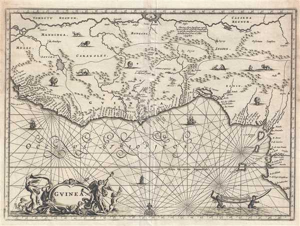 WE SELL ONLY ORIGINAL ANTIQUE MAPS - NOT REPRODUCTIONS Title: Guinea. Description: This is a 1686 Olfert Dapper map of West Africa. The map depicts the region from approximately Mali and Sierra Leone along the Gulf of Guinea to Nigeria and Cameroon and from Mali and Niger to the Gulf of Gunea. Highly detailed, numerous locations are labeled along the coast, while cities and towns dot the interior, usually along one of the rivers. The Niger River flows across the top of the map and several others flow into the Gulf of Guinea, one of which is labeled as the Cameroon River. The modern-day country names of Guinea, Sierra Leone, and Benin are present, along with the 'Gold Coast,' then a British colony, which, following its independence has been known as Ghana. Several vignettes of African animals are included as well, including elephants, lions, a crocodile, and a pair of monkeys. Two ships appear off the coast on their way to India or to purchase West African slaves. At this point in history, the transatlantic slave trade was picking up steam, particularly with Portuguese traders. The Portuguese, who viewed this part of Africa as their property, would take their newly-purchased captives to the West Indies or Brazil. West Africa was at the center of the transatlantic slave trade at this point in history. This map was produced by Olfert Dapper and published by in the French edition of Description of Africa entitled Description de L'Afrique and published in 1686. Size: Printed area measures 10.5 inches high by 14.5 inches wide. Condition: Very good. Wear along margins. Closed margin tears professionally repaired on verso. Blank on verso. Shipping: Shipping rates are not negotiable. Items are shipped within three business days of receiving payment. We are happy to consolidate shipping where possible. The following shipping options are available: 1. FedEx Overnight (45 USD). USA Only. Signature Required. Customs: International buyers are responsible for paying duty and taxes on delivery. DHL or FedEx will contact the buyer by telephone to arrange tax payment if it is levied. Duty varies by country and we cannot predict the amount you will be charged. Some countries are duty free, others are not. Typically, a customs duty and/or VAT tax will be assessed on all parcels to continental Europe. Sometimes duty or tax is due in China, but is seems very random. Hong Kong, Singapore, Korea, and Taiwan have never assessed duty on a map we shipped. Maps shipped to the UK should be duty free as educational materials, but from time to time duty of 5% is assessed incorrectly by the UK customs agents. Insurance: All shipments are insured privately against loss and damage. All of our shipments require a signature for insurance purposes. If you have any questions please feel free to email us through eBay. Other Services Conservation Framing: Geographicus recommends basic conservation framing services for any antique paper. We do not offer this service. |
