1752 Vaugondy Map of Germany 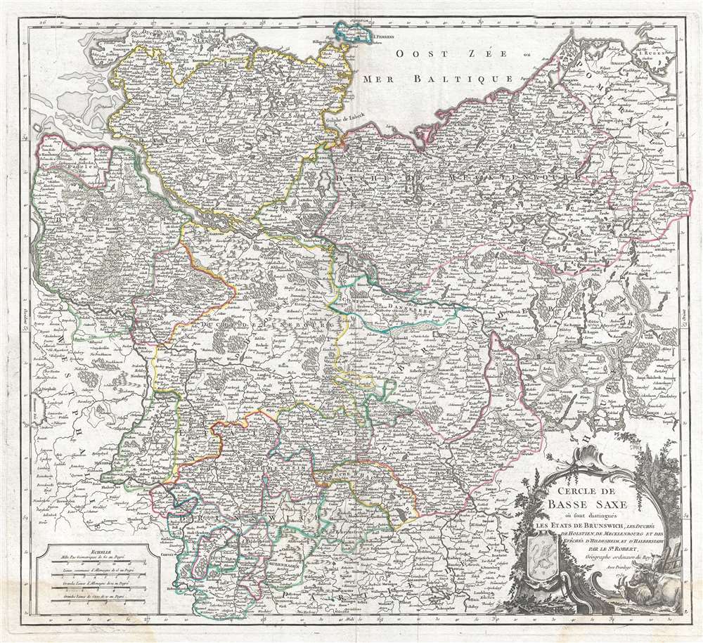 WE SELL ONLY ORIGINAL ANTIQUE MAPS - NOT REPRODUCTIONS Title: Cercle de Basse Saxe ou sont distingues les Etats de Brunswich, les Duches de Holstien, de Mecklenbourg et des Eveches d'Hildesheim, et d'Halberstadt. Description: This is a 1752 Robert de Vaugondy map of Germany. The map depicts the northern part of modern-day Germany from Sleswick south as far as Hall and from Bremen east as far as Berlin, including the circle of Lower Saxony and the states of Brunswick, Holstein, Dutchies of Mecklenburg and bishoprics of Hildesheim, and Halberstadt. The whole is superbly detailed and notes numerous towns, rivers, cities, and a host of additional topographical features. A beautifully engraved title cartouche adorns the lower right quadrant of the map with a coat of arms surrounded by floral ornaments and animals. This map was created by Robert de Vaugondy and published in 1752 edition of the Atlas Universel. The Atlas Universel was one of the first atlases based upon actual surveys. Therefore, this map is highly accurate (for the period) and has most contemporary town names correct, though historic names are, in many cases, incorrect or omitted. Size: Printed area measures 20 inches high by 22 inches wide. Condition: Very good. Original platemark visible. Minor wear along original centerfold. Light foxing. Soiling to lower left and right corners and along margins. Blank on verso. Shipping: Shipping rates are not negotiable. Items are shipped within three business days of receiving payment. We are happy to consolidate shipping where possible. The following shipping options are available: 1. FedEx Overnight (45 USD). USA Only. Signature Required. Customs: International buyers are responsible for paying duty and taxes on delivery. DHL or FedEx will contact the buyer by telephone to arrange tax payment if it is levied. Duty varies by country and we cannot predict the amount you will be charged. Some countries are duty free, others are not. Typically, a customs duty and/or VAT tax will be assessed on all parcels to continental Europe. Sometimes duty or tax is due in China, but is seems very random. Hong Kong, Singapore, Korea, and Taiwan have never assessed duty on a map we shipped. Maps shipped to the UK should be duty free as educational materials, but from time to time duty of 5% is assessed incorrectly by the UK customs agents. Insurance: All shipments are insured privately against loss and damage. All of our shipments require a signature for insurance purposes. If you have any questions please feel free to email us through eBay. Other Services Conservation Framing: Geographicus recommends basic conservation framing services for any antique paper. We do not offer this service. |
