1762 Lotter Map of the World in Hemispheres 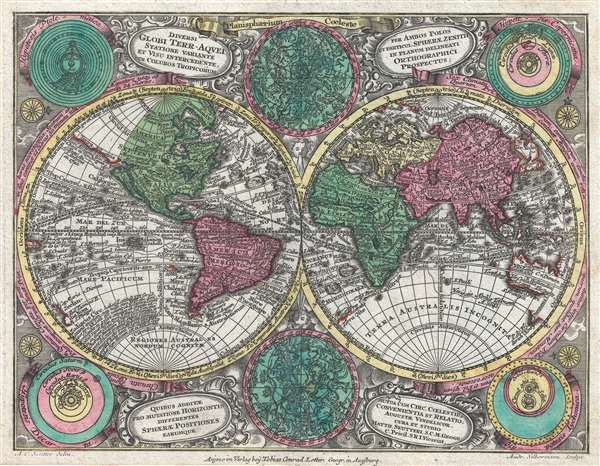 WE SELL ONLY ORIGINAL ANTIQUE MAPS - NOT REPRODUCTIONS Title: Lotter, C. T, Atlas Minorpraecipua Orbis Terrarum Imperia Regna et Provincias, Germaniae potissimum, tabellis 66 exacte delineatis sistens, usui militiae ducum ac peregrinantium maxime accommodatus. (Augsburg: Lotter) 1762.vbn nbm, Description: A beautiful highly decorative full-color c. 1762 double-hemisphere map of the world by Tobias Conrad Lotter. Published for the Atlas Minor, this is a smaller format yet incredibly dense map, with the hemispheres being surrounded by two celestial charts and four conficting cosmographical hypothesies (Ptolemaica, Copernicana, Decarta and Tychonica), as well as rich decorative embellishments. Includes a number of oddities and cartographic anomalies including an illustration of Insular California on the Luke Foxe / Sanson model, an expanse of land leading west from northwestern North America associated with Juan de Gama, an ephemeral New Zealand, the routes of various important explorers, and a loosely defined Australian coastline. Insular CaliforniaThis map is one of the last maps to illustrate California as an Island – clear proof that the original 1730 plate had not been updated significantly. The idea of an insular California first appeared as a work of fiction in Garci Rodriguez de Montalvo's c. 1510 romance Las Sergas de Esplandian, where he writesKnow, that on the right hand of the Indies there is an island called California very close to the side of the Terrestrial Paradise; and it is peopled by black women, without any man among them, for they live in the manner of Amazons.Baja California was subsequently discovered in 1533 by Fortun Ximenez, who had been sent to the area by Hernan Cortez. When Cortez himself traveled to Baja, he must have had Montalvo's novel in mind, for he immediately claimed the 'Island of California' for the Spanish King. By the late 16th and early 17th century ample evidence had been amassed, through explorations of the region by Francisco de Ulloa, Hernando de Alarcon and others, that California was in fact a peninsula. However, by this time other factors were in play. Francis Drake had sailed north and claimed Nova Albion (identified here on the northwest coast of California Island) near modern day Washington or Vancouver for England. The Spanish thus needed to promote Cortez's claim on the 'Island of California' to preempt English claims on the western coast of North America. The significant influence of the Spanish crown on European cartographers, especially the important French house of Sanson, in the form of the presently offered map, caused a major resurgence of the Insular California theory. Gamaland and Compagnie LandtAn unusual orange colored landmass that appears extending westward from northwestern North American is labeled after João da Gama and continues to the Asian side of the map as Compagnie Landt. This is a conflation of two separate but related legends/histories. The first refers to the discoveries of Portuguese explorer João da Gama (c. 1540 – after 1591), grandson of Vasco de Gama, who reputedly crossed the North Pacific in the 1580s, in the process mapping some of the Kuril Islands, possibly some of the Aleutians, and potentially even part of the American Coast. Gama supposedly also discovered islands rich in gold and silver, which led to subsequent expeditions by the Dutch explorers Maarten Gerritszoon Vries (1589 – 1657) and Cornelis Janszoon Coen.Searching for da Gama's islands, Vries and Coen skirted the eastern coast of Japan and Hokkaido (then known as Yedo or Yeco) sighting the Japanese Kuril islands of Kunashir and Iturup. They sailed fully around Kunashir, but only sighted the western shore of the larger Iturup before claiming both islands for the Dutch East India Company (VOC) and naming them Compagnies Landt. Cartographers began combining Gama with Compagnies Landt as a vast singular body of land stretching all the way to America. While based upon actual sightings of the Aleutian and Kuril Islands, limited exploration led explorers to believe they were seeing not a chain of small islands, but rather a part of an expansive mainland. These conclusions would be mirrored later in the 18th century by sophisticated cartographers like Gerhard Friedrich Müller, who rendered the area as a great peninsula, until the dogged and meticulous mapping of Captain James Cook finally shed scientific light on the region. History of the MapThe is one of the few maps drawn by Albrecht Carl Seutter, son of the eminent cartographer Matthä us Seutter, and engraved by Andreas Silbereisen. It was initially issued by Seutter in the 1728 first edition of his Atlas Minor. After Matthä us Suetter's death, Lotter acquired the plate for this map and added his own imprint at bottom center, as in the present example. The states of the map are based exclusively on the imprint with no changes to the map itself. Lotter's imprint was added sometime after 1762, when Albrecht Carl Seutter died. Lotter continued to reissue the Atlas Minor until his own death in 1777.Size: Printed area measures 8 inches high by 10.5 inches wide. Condition: Very good. Blank on verso. Shipping: Shipping rates are not negotiable. Items are shipped within three business days of receiving payment. We are happy to consolidate shipping where possible. The following shipping options are available: 1. FedEx Overnight (45 USD). USA Only. Signature Required. Customs: International buyers are responsible for paying duty and taxes on delivery. DHL or FedEx will contact the buyer by telephone to arrange tax payment if it is levied. Duty varies by country and we cannot predict the amount you will be charged. Some countries are duty free, others are not. Typically, a customs duty and/or VAT tax will be assessed on all parcels to continental Europe. Sometimes duty or tax is due in China, but is seems very random. Hong Kong, Singapore, Korea, and Taiwan have never assessed duty on a map we shipped. Maps shipped to the UK should be duty free as educational materials, but from time to time duty of 5% is assessed incorrectly by the UK customs agents. Insurance: All shipments are insured privately against loss and damage. All of our shipments require a signature for insurance purposes. If you have any questions please feel free to email us through eBay. Other Services Conservation Framing: Geographicus recommends basic conservation framing services for any antique paper. We do not offer this service. |
